Pont Briwet

Last updated

Pont Briwet (1)
Pont Briwet (1).jpg
The previous Victorian Pont Briwet; looking south towards Llandecwyn
Coordinates 52°55′27″N4°03′21″W / 52.9242°N 4.0557°W / 52.9242; -4.0557
Carries Cambrian Coast railway and UK road A4085.svg A4085 (toll)
Crosses River Dwyryd
Locale Penrhyndeudraeth, Gwynedd North Wales
OwnerPrivate
Maintained by Network Rail
Heritage status Grade II listed (formerly)
Characteristics
Pier constructionWood, iron bracing
Total length140 m (460 ft)
Width Standard gauge (4 foot 8½ inch) railway track
10 feet (3.0 m) roadway
Height4 m (13 ft)
Piers in water21
Load limit2 t (2.2 tons) (vehicles)
Design liferebuild GWR (1932)
History
Constructed by Aberystwith and Welsh Coast Railway
Opened1867
Closed2013
Location
Pont Briwet

Pont Briwet refers to the road and railway bridges that cross the River Dwyryd, near Penrhyndeudraeth, Gwynedd in North Wales. The first bridge was a Victorian road and railway viaduct that was constructed entirely from timber by the Cambrian Railways company. [1] Although it was recognised as being a Grade II listed structure, a result of it being an increasingly rare example of a surviving 19th-century wooden road and railway viaduct, the condition of the bridge had deteriorated over time and by the 21st century was posing regular and considerable inconvenience to both road and rail traffic.

Contents

Due to the operational impact of the old bridge, it was decided to build a replacement structure alongside as a joint project between the Welsh government and national rail infrastructure company Network Rail to upgrade the route. Despite plans to retain the old bridge for pedestrian traffic, it was determined that it had been further weakened and rendered structurally unsafe by the piling performed to establish the new bridge's foundations, resulting in its immediate closure in December 2013 and its demolition during the following year.

The new Pont Briwet crosses the Dwyryd on the same alignment as the original structure but it is both stronger and wider to accommodate larger vehicles and traffic volume. It also accommodates a combined cycle path and pedestrian walkway, as well as carrying multiple utilities, such as water and electricity, across its structure. Progress on the new bridge's construction was subject to several delays, the impact of which having been compounded by the necessity of the old structure's closure prior to its completion. It was initially opened only to rail traffic during September 2014; during July 2015, the new bridge was opened to road traffic as well.

History

Victorian bridge

Origins

Prior to the construction of Pont Briwet, the issue of traversing the estuaries at Traeth Mawr and Traeth Bach had been historically troublesome; people had the options of travelling across either on foot or by boat. [2] By the 19th century, a regular ferry service was in operation. Proposals to establish a bridge crossing of the Dwyryd are believed to have been first aired during 1842, however, nothing immediately came of these proposals. [2] During 1861 and 1862, the Aberystwith and Welsh Coast Railway company was authorised by an Act of Parliament to construct a coastal line along Cardigan Bay between the city of Aberystwyth and Porthdinllaen on the Lleyn Peninsula. [3]

The company's selected route, which became commonly known as the Cambrian Coast railway, is largely attributable to the civil engineer Benjamin Piercy, the company's chief engineer at the time. The selected route included the bridge now known as Pont Briwet, which was built to carry the line to the town of Porthmadog. [3] During 1865, the Aberystwyth and Welsh Coast Railway company merged with the rival Cambrian Railways company. Shortly thereafter, boardroom struggles within the newly created company contributed to a delay in the project. [3] Henry Conybeare briefly replaced Piercy as the company's chief engineer, before being himself replaced by Piercy's former deputy, George Owen. It is uncertain which of these were responsible for designing Pont Briwet. [3]

During February 1866, the construction of the bridge was dealt a major setback when the contractor responsible for building it, Thomas Savin, was declared bankrupt. [3] As a consequence, Pont Briwet was not completed until the following year, being officially opened on 10 October 1867. [2] The road over the bridge acted to remove an otherwise-necessary 13 kilometre (8 mile) detour via Maentwrog, a major boon to local residents. [4] The ferry service was soon closed due to it being unable to compete with the newly opened bridge. [2]

Design

The original Pont Briwet was a timber pile viaduct, which were a commonplace feature of coastal railways during this era, being relatively cheap and flexible structures in comparison to the common alternatives. [3] [2] It accommodated both a single track for rail traffic as well as a single lane of roadway for a toll road. Although the bridge was decked with timber planks, the road carriageway was waterproofed with a metalled surface. [3] The deck was carried upon 22 equal spans, which were evenly spaced at intervals of 5.8 metres. The bridge was furnished with substantial battered abutments, composed of rough blocks of slate that were in excess of 40 metres in terms of length. [3]

The piers of the bridge comprised either four or five timber piles, each roughly 350mm across, which were connected by crosshead timbers and braced with diagonals. [3] Iron was used for the bolts and bracing bars used to fix elements in place. These created a series of frames on which longitudinal beams carried both the road and railway; those beams that were underneath the tracks were substantially larger than those under the roadway due to the greater weight of trains in comparison to road vehicles during that time. [3]

Operational life

During 1932, the bridge was extensively rebuilt by the Great Western Railway (GWR) company, into which Cambrian Railways had been amalgamated during the 1920s. During this work, half of the wooden piles were replaced with new creosoted pitch pine; it is believed that in excess of 183 tonnes of timber were removed during the replacement process. [3] Additional changes made to the structure also included alterations to the cross members and bracings. As a consequence of this work, the overall width of the bridge was increased to 8.5 m (28 ft). [3]

A less popular practice of Pont Briwet was the toll that was in place for road vehicles. [4] During 1909, the local council lent its support towards efforts to abolish the tolls on the bridge; however, this pressure was ultimately unsuccessful at removing the tolls as the practice survived until the closure of the original bridge during the early 21st century. By 2009, toll prices were 40p for cars, as well as 30p for trailers and motorcycles. [4] Despite the nationalisation of the "Big Four" British railway companies during early 1947, the viaduct remained a privately owned toll road for road traffic travelling between Penrhyndeudraeth and Harlech. Over time, the roadway was redesigned to control vehicle movements using sets of traffic lights that were located at either end of the bridge. [3]

Reportedly, the bridge and line benefited heavily from the freight traffic generated after the establishment of Cooke's explosives factory near Penrhyndeudraeth during 1872. [2]

By 2010, a speed limit of 20 mph (32 km/h) had been imposed on all trains crossing the bridge. Additionally, in terms of road vehicles, the structure could only accommodate single-file traffic, serving both directions of traffic by alternating between the two. [3] It was also restricted to those vehicles that weighed less than 2 t (2.2 tons); as a result of this restriction, the route was only passable by cars, which meant that all heavier vehicles would have to go through a 8 miles (13 km) detour, significantly affecting the journeys of ambulances and buses, along with vans and lorries. [5] Pedestrians were also unable to use the bridge because of the narrow width of the carriageway. [6]

Replacement

Pont Briwet (2)
Completed IMG 3988 -1.jpg
Completed Pont Briwet rail crossing
Coordinates 52°55′27″N4°03′21″W / 52.9242°N 4.0557°W / 52.9242; -4.0557
Carries Cambrian Coast railway
UK road A4085.svg A4085
Crosses River Dwyryd
Locale Penrhyndeudraeth, Gwynedd North Wales
Characteristics
Pier construction concrete, steel
Width18 m (59 ft) (completed)
Piers in water6
History
Opened2014 (rail)
2015 (road)
ReplacesVictorian wooden viaduct
Location
Pont Briwet
Planning

During July 2010, the Welsh Assembly Government announced the launch of a £20 million joint project with national rail infrastructure company Network Rail that intended to produce a new structure to replace the existing bridge by 2013. [7] [8] At the time, it was stated that the old bridge was to be retained as a result of its listed status; following the opening of the new bridge, it was intended that it would be transformed into a pedestrian walkway. [5] However, soon after the commencement of work on the new structure, approval was granted for the old viaduct's demolition during February 2012. [9]

The new Pont Briwet would carry the single-track railway plus a two-lane carriageway and a 2.5 m (8 ft 2 in) combined cycleway and footpath. The road's speed limit would be raised to 40 mph (64 km/h) and toll charges abolished. [10] [11] Although the road and rail bridges share the same pillars, like the original viaduct, the superstructures of the new crossings would be separate. Planners also said that, apart from a four-week period in which work would be undertaken to relocate electrical cabling, the old viaduct would remain open throughout the works. [12]

Design and Construction

During March 2013, work commenced upon the construction of the new bridge. [13] [14] However, in November 2013, it was announced that the existing wooden bridge had been found to have been affected by the piling activity performed to produce the new bridge's foundations. The old bridge was declared structurally unsafe and closed to all traffic during December 2013. The closure necessitated an 8-mile diversion via Maentwrog for road users and rail services were terminated at Harlech, closing the 22 miles (35 km) line to Pwllheli via Porthmadog. [15] [16] A new temporary road bridge was due to be in place by Spring 2014, but this plan was shelved by Gwynedd County Council in favour of a controlled traffic management system on the A496 between Maentwrog and Llandecwyn because of safety fears related to increased traffic on the A496. [17] [18]

The 'design and build' contract was awarded to Hochtief and Hewson Consulting acted as their lead consultant for the multi-disciplinary design team. The design of the replacement bridge features the extensive use of the innovative precasting technique which accelerated the construction activities and minimised the disruption to surrounding watercourse.[ citation needed ]

Completion

On 1 September 2014, the new rail viaduct was opened for services between Harlech and Pwllheli. [19] However, work continued into the following year on the accompanying roadway; progress on its construction had been delayed by difficulty in the relocation of electricity cables and a water main that previously crossed the old bridge. After two years of work and some significant delays, the road crossing was finally opened to traffic in the summer of 2015. [20] [21]

See also

Related Research Articles

Snowdonia Mountainous region in north Wales

Snowdonia is a mountainous region in northwestern Wales and a national park of 823 square miles (2,130 km2) in area. It was the first to be designated of the three national parks in Wales, in 1951.

A487 road Trunk road in Wales

The A487, officially the Fishguard to Bangor Trunk Road, is a trunk road in Wales that follows the coast from Haverfordwest, Pembrokeshire, in the south, to Bangor, Gwynedd, in the north.

Cambrian Line Railway line in Wales, and in Shropshire, England

The Cambrian Line, also known as the Cambrian Main Line and Cambrian Coast Line, is a railway line that runs from Shrewsbury, England, westwards to Aberystwyth and Pwllheli in Wales. Passenger train services are operated by Transport for Wales Rail between the western terminals of Pwllheli, Gwynedd, and Aberystwyth, Ceredigion, with the eastern terminal at Shrewsbury, Shropshire as part of the Wales & Borders franchise. The railway line is regarded to be scenic, as it passes through the Cambrian Mountains in central Wales, Snowdonia National Park and along the coast of Cardigan Bay.

River Dwyryd River in Gwynedd, Wales

The River Dwyryd is a river in Gwynedd, Wales which flows principally westwards; draining to the sea into Tremadog Bay, south of Porthmadog.

Boston Lodge

Boston Lodge is situated at Penrhyn Isa, Minffordd, Penrhyndeudraeth, on the A487 road about 1 mile SE across the Afon Glaslyn causeway from Porthmadog, Gwynedd in north-west Wales.

Traeth Mawr Polder in Gwynedd, North Wales

Traeth Mawr is a polder near Porthmadog in Gwynedd in Wales. The area was formerly the large tidal estuary of the Afon Glaslyn. It was created after large-scale land reclamation occurred in the late 18th century and the early 19th century. A large embankment, called the Cob, separates the area from the sea and carries a road and railway line.

Barmouth Bridge Railway bridge across the Mawddach estuary

Barmouth Bridge, or Barmouth Viaduct is a Grade II* listed single-track wooden railway viaduct across the estuary of the Afon Mawddach near Barmouth, Wales. It is 820 metres (900 yd) long and carries the Cambrian Line. It is the longest timber viaduct in Wales and one of the oldest in regular use in Britain.

Penrhyndeudraeth Human settlement in Wales

Penrhyndeudraeth is a small town and community in the Welsh county of Gwynedd. The town is close to the mouth of the River Dwyryd on the A487 nearly 3 miles (4.8 km) east of Porthmadog, and had a population of 2,150 at the 2011 census, increased from 2,031 in 2001. The community includes Minffordd and Portmeirion.

Pwllheli railway station Railway station in Gwynedd, Wales

Pwllheli railway station is a railway station serving the small coastal town of Pwllheli on the Llŷn Peninsula in Gwynedd, Wales. It is the terminus of the Cambrian Coast Railway.

Severn Bridge Bridge over the rivers Severn and Wye in England and Wales

The Severn Bridge is a motorway suspension bridge that spans the River Severn between South Gloucestershire in England and Monmouthshire in South East Wales. It is the original Severn road crossing between England and Wales, and took three and a half years to build, at a cost of £8 million. It replaced the 137-year-old Aust Ferry.

Porthmadog Harbour railway station

Porthmadog Harbour railway station in Porthmadog, Gwynedd, North Wales. It is the passenger terminus of two narrow gauge railways: the Ffestiniog Railway, which was opened in 1836 to carry dressed slate from the Quarries around Blaenau Ffestiniog to the sea port of Porthmadog, for export by sea; and the Welsh Highland Railway, incorporated in 1923, which ran to Dinas. After rebuilding in 1997-2011, the other terminus is at Caernarfon, in sight of the Castle.
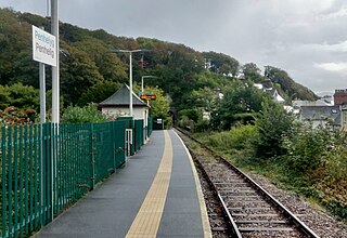
Maentwrog Village in Merionethshire, Wales

Maentwrog is a village and community in the Welsh county of Merionethshire, lying in the Vale of Ffestiniog just below Blaenau Ffestiniog, within the Snowdonia National Park. The River Dwyryd runs alongside the village. Its population of 585 in 2001 increased to 631 at the 2011 Census. The Community of Maentwrog includes the village of Gellilydan.

Harlech railway station Railway station in Gwynedd, Wales

Harlech railway station is located at a level crossing on the A496 in the centre of the town of Harlech in Gwynedd, North Wales. The waiting shelters were installed to cater for the high numbers of schoolchildren commuting to and from the adjacent secondary school, Ysgol Ardudwy.

Porthmadog railway station Railway station in Gwynedd, Wales

Porthmadog railway station serves the town of Porthmadog on the Llŷn Peninsula in Gwynedd, Wales. The station is on the Cambrian Coast Railway with passenger services to Pwllheli, Harlech, Barmouth, Machynlleth, Shrewsbury and Birmingham.
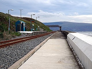
Llanaber railway station Railway station in Gwynedd, Wales

Llanaber railway station serves the village of Llanaber near Barmouth in Gwynedd, Wales. The station is an unstaffed halt on the Cambrian Coast Railway with passenger services to Harlech, Porthmadog, Pwllheli, Barmouth, Machynlleth and Shrewsbury. Most trains call only on request.

Barmouth railway station Railway station in Gwynedd, Wales

Barmouth railway station serves the seaside town of Barmouth in Gwynedd, Wales. The station is on the Cambrian Coast Railway with passenger services to Harlech, Porthmadog, Porthmadog, Tywyn, Aberdovey, Machynlleth and Shrewsbury. Between Morfa Mawddach and Barmouth the railway crosses the Afon Mawddach on the Barmouth Bridge.

Pont Croesor railway station

Pont Croesor is a railway halt in Wales, on the Welsh Highland Railway, which runs through the Snowdonia National Park from Caernarfon to Porthmadog. It is located on the section between the stations of Hafod y Llyn and Pen-y-Mount Junction.

A498 road

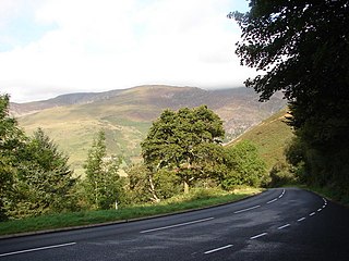
The A498 is a 16-mile road between Pen-y-Gwryd and Porthmadog in North Wales.

Llandecwyn Human settlement in Wales

Llandecwyn is a hamlet near Penrhyndeudraeth in Gwynedd, Wales.

Llanfihangel-y-traethau Parish in Local government area, Wales

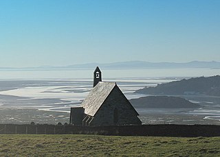
Llanfihangel-y-traethau was a parish in Ardudwy, Gwynedd, north-west Wales centred on a church of the same name in the village of Ynys. The original parish church was built in the 12th century on a tidal island. Later the land rose and connected the island to the mainland. Today it is part of the Bro Ardudwy ministry area, which includes Harlech, a few kilometres to the southwest, and Barmouth. The church has a window depicting Saint Tecwyn and is the start of the Saint Tecwyn's Way, a pilgrimage route ending at Saint Tecwyn's church in Llandecwyn.

References

Citations

  1. Baugham, P. E. (1980). A Regional History of the Railways of Great Britain. Vol. XI. London.
  2. 1 2 3 4 5 6 "Pont Briwet." walesher1974.org, GAT Project No. 2144. Report No. 894. October 2010.
  3. 1 2 3 4 5 6 7 8 9 10 11 12 13 14 “Pont Briwet (1867), site of.” ‘’ engineering-timelines.com’’, Retrieved: 6 June 2018.
  4. 1 2 3 "Pont Briwet, near Penrhyndeudraeth." historypoints.org, Retrieved: 6 June 2018.
  5. 1 2 "New £20m road and rail bridge plan for Penrhyndeudraeth". BBC Wales News. 12 July 2010. Retrieved 13 July 2010.
  6. "New Gwynedd Bridge Shortens Path by 10 Miles!" walescoastpath.gov.uk, Retrieved: 6 June 2018.
  7. "Pont Briwet Road and Rail Bridge." gov.wales.uk, Last updated: 17 May 2016.
  8. "Pont Briwet, Penrhyndeudraeth." rba.ltd.uk, 31 October 2017.
  9. "Pont Briwet demolition plans approved by Snowdonia National Park". BBC News. 22 February 2012.
  10. "Penrhyndeudraeth-Harlech bridge replacement under way". BBC News . British Broadcasting Corporation. 15 March 2013. Retrieved 20 January 2014.
  11. "Wales." notolls.org.uk, Retrieved: 6 June 2018.
  12. "Penrhyndeudraeth-Harlech bridge closes for cable work". BBC News . British Broadcasting Corporation. 15 April 2013. Retrieved 20 January 2014.
  13. "The design and construction of the Pont Briwet Viaduct, UK." Institute of Civil Engineers, Volume 171, Issue 2. June 2018. pp. 80-90.
  14. "Pont Briwet bridge replacement contract awarded." Rail Technology Magazine, 19 March 13.
  15. "Railway line closed after work destabilises rail and road crossing in North Wales". Daily Post. 6 November 2013.
  16. Crump, Eyrl. "Pont Briwet: Buses to replace vital railway link until summer 2014." Daily Post, 31 March 2014.
  17. "Pont Briwet bridge closed over safety as £20m crossing built". BBC News . British Broadcasting Corporation. 13 January 2014. Retrieved 20 January 2014.
  18. Milner, Chris (1 January 2014). "Bridge fiasco could close Porthmadog line until 2015". The Railway Magazine . Mortons Media Group. Archived from the original on 18 January 2014. Retrieved 20 January 2014.
  19. "Pont Briwet Road Maintenance and Improvement Scheme". Gwynedd County Council. Archived from the original on 8 September 2014. Retrieved 8 September 2014.
  20. "Long-awaited Pont Briwet opens after more than two years of building work". North Wales Daily Post . 13 July 2015. Retrieved 19 July 2015.
  21. Smith, Nicola. "Video: New £20m Pont Briwet bridge officially opens to cars." BBC News, 13 July 2015.