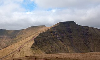
The Brecon Beacons are a mountain range in Wales. The range includes South Wales's highest mountain, Pen y Fan, its twin summit Corn Du, and Craig Gwaun Taf, which are the three highest peaks in the range. The Brecon Beacons have given their name to the larger Brecon Beacons National Park, and the range itself is therefore sometimes known as the Central Beacons to differentiate the two.

Powys is a county and preserved county in Wales. It borders Gwynedd, Denbighshire, and Wrexham to the north; the English ceremonial counties of Shropshire and Herefordshire to the east; Monmouthshire, Blaenau Gwent, Merthyr Tydfil, Caerphilly, Rhondda Cynon Taf, and Neath Port Talbot to the south; and Carmarthenshire and Ceredigion to the west. The largest settlement is Newtown, and the administrative centre is Llandrindod Wells.

Until 1974, Brecknockshire, also formerly known as the County of Brecknock, Breconshire, or the County of Brecon, was an administrative county in the south of Wales, later classed as one of the thirteen historic counties of Wales. Named after its county town of Brecon, the county was mountainous and primarily rural.

Merthyr Tydfil is the main town in Merthyr Tydfil County Borough, Wales, administered by Merthyr Tydfil County Borough Council. It is about 23 miles (37 km) north of Cardiff. Often called just Merthyr, it is said to be named after Tydfil, daughter of King Brychan of Brycheiniog, who according to legend was slain at Merthyr by pagans about 480 CE. Merthyr generally means "martyr" in modern Welsh, but here closer to the Latin martyrium: a place of worship built over a martyr's relics. Similar place names in south Wales are Merthyr Cynog, Merthyr Dyfan and Merthyr Mawr.

Brecon Beacons National Park, officially named Bannau Brycheiniog National Park, is a national park in Wales. It is named after the Brecon Beacons, the mountain range at its centre. The national park includes the highest mountain in South Wales, Pen y Fan, which has an elevation of 886 metres (2,907 ft).

The Taff Trail is a walking and cycle path that runs for 55 miles (89 km) between Cardiff Bay and Brecon in Wales. It is so named because it follows the course of the River Taff. Along much of its length, it follows the National Cycle Network Route 8 that continues to Holyhead, and is substantially off-road.

The River Taff is a river in Wales. It rises in the Brecon Beacons as two rivers, the Taf Fechan and the Taf Fawr before becoming one just north of Merthyr Tydfil. At Cardiff, it empties into the Bristol Channel.

The Brecon Mountain Railway is a 1 ft 11+3⁄4 in narrow gauge tourist railway on the south side of the Brecon Beacons in Wales. It climbs northwards from Pant along the full length of the Pontsticill Reservoir and continues past the adjoining Pentwyn Reservoir to Torpantau railway station. The railway's starting point at Pant is located two miles (3 km) north of the town centre of Merthyr Tydfil, Merthyr Tydfil County Borough, South-East Wales.
Afon Hepste is a river in Powys, Wales, though partly forming the county's border with Rhondda Cynon Taf. It runs wholly within the Brecon Beacons National Park.

Vaynor is a village and community in Merthyr Tydfil County Borough in Wales, United Kingdom. The population of the community at the 2011 census was 3,551.
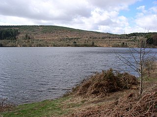
Llwyn-onn Reservoir is the largest and southernmost of the three reservoirs in the Taf Fawr valley in South Wales. Cardiff Corporation Waterworks obtained an Act of Parliament in 1884 to authorise construction of the reservoirs, to increase the water supply for Cardiff, but construction of Llwyn-onn Reservoir did not start until 1911 and was completed in the 1920s.

Cefn yr Ystrad is a mountain in the Brecon Beacons National Park in Wales. It is an outlier of the Central Beacons group.

Fan Fawr is a mountain in the Fforest Fawr section of the Brecon Beacons National Park, in Powys, Wales and over 734 m (2,408 ft) high.

Aber Village or Aberclydach is a hamlet within the Brecon Beacons National Park in Powys, Wales. It is centred on the minor road which runs south from Talybont-on-Usk up the Caerfanell valley known as Glyn Collwn across the Brecon Beacons to Pontsticill and Merthyr Tydfil. Aberclydach lies within the community of Talybont-on-Usk about 1.5 km to the south of the village of Talybont and 0.5 km to the north of the dam of Talybont Reservoir.

Pontsticill is a village within the County Borough of Merthyr Tydfil in South Wales. It lies within the valley of the Taf Fechan on the southern edge of the Brecon Beacons National Park. The village lies within the community of Vaynor in an area that was, until the local government re-organisation of 1974, within the historic county of Brecknockshire.

Cefn-coed-y-cymmer is a small community on the northwestern edge of Merthyr Tydfil County Borough in Wales. It is situated in the neck of land between the rivers Taf Fawr and Taf Fechan at their confluence. The village lies within the community of Vaynor. Immediately to the north of the village is the hill of Cefn Cil Sanws on the southern slopes of which is Merthyr Tydfil Golf Club. The village is bounded both to the north and the west by the Brecon Beacons National Park.

Torpantau railway station is a station in the Welsh county of Brecknockshire, and the northern terminus of the narrow gauge Brecon Mountain Railway.
Local and national public authorities in the Welsh town of Merthyr Tydfil have taken considerable steps towards improving social, economic, cultural and environmental sustainability in the area. This has included funding from charities, organisations and local government. The Merthyr Tydfil council has put in place policies to regulate development on natural heritage sites, along with preserving the local history and culture. The building of homes within Merthyr Tydfil has also been influenced to create environmentally sustainable homes, with the use of renewable energy sources.

Pontsticill railway station is an intermediate station on the Brecon Mountain Railway at Pontsticill, in the historic Welsh county of Brecknockshire, now Merthyr Tydfil County Borough.


