This article includes a list of general references, but it lacks sufficient corresponding inline citations .(May 2021) |
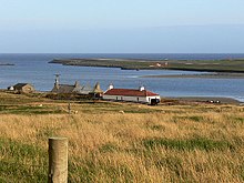
The Pool of Virkie is a tidal lagoon in the parish of Dunrossness, south Mainland, Shetland.
Contents
This article includes a list of general references, but it lacks sufficient corresponding inline citations .(May 2021) |
The Pool of Virkie is a tidal lagoon in the parish of Dunrossness, south Mainland, Shetland.
The Pool of Virkie, during the late 15th and early 16th centuries, when it was much deeper than it is today, became the main Hanseatic trading centre for the south end of Shetland. Because of this trade it became known as the Dutch Pool. This name was chosen because locals pronounced Deutsch as Dutch. The actual Dutch visitors were called Hollanders. [1] Flint stones are to be found around the shores of the Pool and as flint does not occur naturally in Shetland, it is assumed these are discarded ballast stones from the continental boats.
At the end of the 16th century the Pool silted up and became much as it is today, [2] with the only anchorage available towards the east end or in the Virkie Marina, which was formed in the 1980s.
Because of the large area exposed by the ebb tide, the Pool of Virkie has become an important site for bird watching in the South Mainland. [3] It adjoins Sumburgh Airport

Fair Isle, sometimes Fairisle, is the southernmost Shetland island, situated roughly 38km from the Shetland Mainland and about 43km from North Ronaldsay. The entire archipelago is located off of the northernmost coast of Scotland, in the North Sea. As the most remote inhabited island within the United Kingdom, Fair Isle is known for its wild bird observatory, interesting historic shipwrecks, Scottish and Shetland-style traditional music, and its traditional style of knitting. The island has been owned by the National Trust for Scotland since 1954.

The Mainland, also known as Hrossey and Pomona, is the main island of Orkney, Scotland. Both of Orkney's burghs, Kirkwall and Stromness, lie on the island, which is also the heart of Orkney's ferry and air connections.

Mousa is a small island in Shetland, Scotland, uninhabited since the nineteenth century. The island is known for the Broch of Mousa, an Iron Age round tower, and is designated as a Special Protection Area for storm-petrel breeding colonies.

South Havra, formerly Hevera, is an uninhabited island in the Scalloway Islands, Shetland, Scotland.

The Lochs of Spiggie and Brow are located west of Boddam in the parish of Dunrossness, in the South Mainland of Shetland, Scotland, about 6 km north of Sumburgh.
St Ninian's Isle is a small tied island connected by the largest tombolo in the UK to the south-western coast of the Mainland, Shetland, in Scotland. It is part of the civil parish of Dunrossness on the South Mainland. The tombolo, known locally as an ayre from the Old Norse for "gravel bank", is 500 metres long. During the summer the tombolo is above sea level and accessible to walkers. During winter, stronger wave action removes sand from the beach so that it is usually covered at high tide, and occasionally throughout the tidal cycle, until the sand is returned the following spring. Depending on the definition used, St. Ninian's is thus either an island, or a peninsula; it has an area of about 72 hectares.

Old Scatness is an archeological site on Scat Ness, near the village of Scatness, in the parish of Dunrossness in the south end of Mainland, Shetland, Scotland, near Sumburgh Airport. It consists of medieval, Viking, Pictish, and Iron Age remains and has been a settlement for thousands of years, each new generation adding buildings, and levelling off old ones. Among the discoveries is an Iron Age broch, the Ness of Burgi fort.

Symbister is the largest village and port on Whalsay, an island in the Shetland archipelago of Scotland. The population in 1991 was 797. The focus of the village is the harbour, which is home to small fishing boats as well as large deep sea trawlers. The village is overlooked by the granite mansion Symbister House, built by the Sixth Robert Bruce of Symbister in 1823. The harbour is also known by the names Bay Of Symbister, Symbister Harbour and Symbister Old Harbour.
Horse Island or Horse Holm, known locally as Da Holm, is one of the Shetland Islands. It lies about 2.3 km west of Sumburgh Head at the south tip of the Mainland, Shetland. In the Norn language, it was called Hundiholmi but was later renamed Horse Holm. It is used as an alignment point by local fishermen for several fishing marks.

Dunrossness, is the southernmost parish of Shetland, Scotland. Historically the name Dunrossness has usually referred to the area on the Shetland mainland south of Quarff. However, in 2016 there were three separate Shetland Community Councils for a) Gulberwick, Quarff and Cunningsburgh; b) Sandwick; and c) Dunrossness. The 2011 census defined Dunrossness as including everybody within the British ZE2 postal code, which goes as far north as Gulberwick. It has the best and largest area of fertile farmland of any parish in Shetland. Dunrossness includes the island of Mousa, Levenwick, St Ninian's Isle, Bigton, Scousburgh, the Lochs of Spiggie and Brow, Boddam, Quendale, Virkie, Exnaboe, Grutness, Toab, Ness of Burgi, Clumlie Broch, Scatness, Sumburgh Airport, Sumburgh Head, West Voe, the islands of Lady's Holm, Little Holm, Horse Holm island and Fair Isle.

Tingwall, is a parish in Shetland, Scotland. Located mostly on the Shetland Mainland, the centre lies about 2 miles north of Scalloway. Tingwall Airport is located in the village.

Virkie is the most southerly district of Shetland, other than Fair Isle and is best defined as the area south of the Ward Hill in Dunrossness, also locally referred to as "below da hill", or "da laich Ness".
El Gran Grifón was the flagship of the Spanish Armada's supply squadron of Baltic hulks ; see List of Ships of the Spanish Armada. She was shipwrecked on Fair Isle, Shetland, Scotland, on 27 September 1588.

Cunningsburgh, formerly also known as Coningsburgh, is a new hamlet and ancient parish in the south of Mainland, Shetland, Scotland. The hamlet is on the coast, nine miles south south west of Lerwick, about halfway between there and Sumburgh Head. The parish was merged with Dunrossness and Sandwick in 1891. It is on the A970 road. There is a primary school, a marina, a community shop, a public hall, a history centre, a touring park, and a United Free Church of Scotland kirk.

Nesting is a parish in the Shetland Islands, Scotland. It includes a part of the east Shetland Mainland, measuring about twelve by four miles, along the seaboard from Gletness to Lunna Ness, and also the island of Whalsay and the Out Skerries. The coast is deeply indented by voes and headlands. The arable land comprises only about 1,000 acres, the remainder being mostly open moorland. The total area is given as 105.6 km2. This includes the ancient parish of Lunnasting in the North and the island parish of Whalsay to the east, which were added to Nesting in 1891. Before that, the ancient parishes of North Nesting and South Nesting were merged.
Sandsting is a parish in the West Mainland of Shetland, Scotland, forming a southern arm of the Walls Peninsula. After the parish of Aithsting was annexed into Sandsting in the sixteenth century, it became known as Sandsting and Aithsting parish.

Sandwick is a parish on the west coast of Mainland, Orkney, Scotland, 4 miles (6.4 km) north of Stromness.


Sandwick is a village and an ancient parish in the Shetland Islands, Scotland. It was merged in 1891, along with Cunningsburgh, into Dunrossness. Sandwick is located 13 miles (21 km) south of Lerwick in the South Mainland, and is considered a Tier 1 settlement in Shetland. It comprises a number of distinct settlements in very close proximity to each other, each remaining distinct through being separated by agricultural land. These settlements within Sandwick include Old Sandwick, Leebitton, Broonies' Taing, Stove, Swinister and Hoswick; the latter is almost a village in its own right and is often considered distinct from Sandwick.

59°53′4″N1°17′40″W / 59.88444°N 1.29444°W
| | This Shetland location article is a stub. You can help Wikipedia by expanding it. |