Transport in the Maldives includes, road, water and air. The country has no railways.

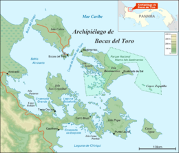
Bocas del Toro (Spanish pronunciation: [ˈbokaz ðel ˈtoɾo]; meaning "Mouths of the Bull") is a province of Panama. Its area is 4,643.9 square kilometers, comprising the mainland and nine main islands. The province consists of the Bocas del Toro Archipelago, Bahía Almirante, Chiriquí Lagoon, and adjacent mainland. The capital is the city of Bocas del Toro on Isla Colón. Other major cities or towns include Almirante and Changuinola. The province has a population of 125,461 as of 2010.

The Central Province is one of the provinces of Solomon Islands, covering the Russell Islands, Nggela Islands and Savo Island. Its area comprises 615 square kilometres and had a population of 26,051 as of 2009, rising to 30,326 as of 2019. The provincial capital is Tulagi.

Banco Chinchorro is an atoll reef lying off the southeast coast of the Municipality of Othón P. Blanco in Quintana Roo, Mexico, near Belize. It was featured throughout the 2009 semi-documentary film Alamar by Pedro González-Rubio.

The Kingdom of Elleore is a micronation located on the island of Elleore in the Roskilde Fjord, north of Roskilde on the Danish island of Zealand.

The Bocas del Toro Archipelago is a group of islands in the Caribbean Sea in the northwest of Panama. The archipelago separates Almirante Bay and Chiriquí Lagoon from the open Caribbean Sea. The archipelago is part of the Bocas del Toro District which is part of Bocas del Toro Province. The major city is Bocas del Toro, also called Bocas Town, on Isla Colón. The islands are accessible by water taxis and private boats. Isla Colón is accessible by airplanes, ferries, private boats, and water taxis. Bocas del Toro "Isla Colón" International Airport, located just west of Bocas Town, provides air transportation to and from the islands. Ferries serve Bocas Town from Almirante, Changuinola, and Chiriquí Grande.

San Andrés is a coral island in the Caribbean Sea. Politically part of Colombia, and historically tied to the United Kingdom, San Andrés and the nearby islands of Providencia and Santa Catalina form the department of San Andrés, Providencia and Santa Catalina. San Andrés, in the southern group of islands, is the largest of Colombia. The official languages of the department are Spanish, English, and San Andrés–Providencia Creole.
Carenero Island is a long and forested island located just a few hundred meters east of Isla Colón, in the Bocas del Toro Archipelago, Panama. The name of the island comes from the nautical term careening, which means to lean a ship on its side for repairing or scraping its hull. There are no roads on the island.
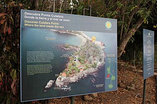
The Punta Culebra Nature Center is a visitor center located in Panama City, on one of the islands connected by the Amador Causeway. It is operated by the Smithsonian Tropical Research Institute, also located in Panamá. The center focuses mainly on marine and terrestrial science and education, conservation and interpretation of marine coastal environments in the tropics. Among its attractions, the Fabulous Frogs of Panama, a touch tank with equinoderms and turtles are some of the exhibits found in Punta Culebra. A trail to a stretch of tropical dry forest is also part of the attractions where free roaming animals such as raccoons, sloths, green iguanas and beautiful birds and butterflies can be found.
Cayo Agua is the eastern and southernmost island in the Bocas del Toro Archipelago, Panama, separating Chiriquí Lagoon in the south from the Caribbean Sea in the north. It has a surface area of 16 km2.

Isla Bastimentos National Marine Park is a marine park located in the Bocas del Toro Archipelago, Panama. The park covers 13,226 hectares.
Salt Creek is a Ngöbe Buglé village located on the southeastern end of Bastimentos island, in the Bocas del Toro Archipelago, Province and District of Panama.

Gardiki Castle is a 13th-century Byzantine castle on the southwestern coast of Corfu and the only surviving medieval fortress on the southern part of the island. It was built by a ruler of the Despotate of Epirus, and was one of three castles which defended the island before the Venetian era (1401–1797). The three castles formed a defensive triangle, with Gardiki guarding the island's south, Kassiopi Castle the northeast and Angelokastro the northwest
Isla San Telmo is located in the southeast area of the Pearl Islands in Panama. It is the first landsighting when sailing to the port of Panama. The Reserva Natural Isla San Telmo was established in 1996 as a protection measure for the island; marine turtles are noted on the beaches, endemic birds and animals are found in the premontane forest, and the island waters are a whale breeding area.

Pélé Island, sometimes spelled Pele in English, is a volcanic island located 11,2 miles north of the island of Éfaté in the Shefa Province of the Republic of Vanuatu. It has a total area of 1.7 square miles, Pélé is inhabited by about 200-220 Ni-Vanuatu villagers residing in the four villages: Worsiviu, Worearu, Piliura, and Launamoa. Pélé Island is a part of the MPA Nguna-Pele Marine Protected Area, which was established in 2003, and is a popular Vanuatuan diving location. The Nguna-Pele Marine Protected Area covers a total area of 11.5 sq. mi., including numerous reefs, sea grass beds, mangrove forests and intertidal lagoons. The Nguna-Pele Marine Protection Agency is located in the village of Piliura, and mounts an exhibition and sells T-shirts. Income from tourism is distributed by the Village Tourism Committee and supports aims as village water supply projects. The island can be visited daily by boat from the Paonangisu area by the town of Emua on Éfaté's north coast. There are also yachts available both from Emua and Nguna for day and overnight charters to the island. The island is nearly adjacent to the island of Nguna, with a small passage no deeper than 33 yards separating the two. It has a tropical climate and has a maximum elevation of 650 feet at its highest. Much of the island is extremely steep and rocks prevent you from walking along the coastline around the island. White sandy beaches are found in Piliura, Worearu, Laonamoa, and Sake. Overpopulation has led to a steady migration from Pele villages to southern Nguna in recent times.

Chiriquí Lagoon is a large lagoon on the northwest coast of Panama covering an area of about 900 square kilometres (350 sq mi). It is separated from the Caribbean Sea by the Valiente Peninsula to the east and from Almirante Bay by islands in the Bocas del Toro Archipelago to the northwest, including Cayo Agua and Isla Popa. The widest and deepest entrance into the bay is the Canal del Tigre in the northeast, which is the main access channel for ships entering the lagoon.
Tula is a village in the Eastern District of Tutuila Island in American Samoa. Tula is located in Vaifanua County and had a population of 405 as of the 2010 U.S. Census.
Popa Game Park is a game park in Namibia, around the series of cascading rapids known as Popa Falls in the Okavango River, where the river crosses the Caprivi Strip in Kavango East, between Divundu and Bagani. During low water one can see that the difference of elevation is ca. 4 meters.