Taranaki is a region in the west of New Zealand's North Island. It is named after its main geographical feature, the stratovolcano of Mount Taranaki, also known as Mount Egmont.
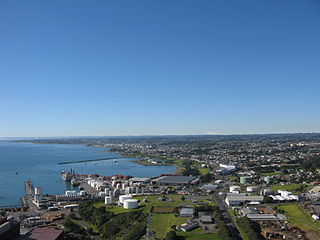
New Plymouth is the major city of the Taranaki region on the west coast of the North Island of New Zealand. It is named after the English city of Plymouth, Devon from where the first English settlers to New Plymouth migrated. The New Plymouth District, which includes New Plymouth City and several smaller towns, is the 10th largest district in New Zealand, and has a population of 87,300 – about two-thirds of the total population of the Taranaki Region and 1.7% of New Zealand's population. This includes New Plymouth City (58,400), Waitara (7,290), Inglewood (3,790), Ōakura (1,690), Ōkato (561) and Urenui (429).

Mount Taranaki or Taranaki Maunga, also known as Mount Egmont, is a dormant stratovolcano in the Taranaki region on the west coast of New Zealand's North Island. It is the second highest point in the North Island, after Mount Ruapehu. The 2,518-metre (8,261 ft) mountain has a secondary cone, Fanthams Peak, 1,966 metres (6,450 ft), on its south side.

Waitara is a town in the northern part of the Taranaki region of the North Island of New Zealand. Waitara is located just off State Highway 3, 15 kilometres (9.3 mi) northeast of New Plymouth.
Richard "Dicky" Barrett (1807–1847) was one of the first European traders to be based in New Zealand. He lent his translation skills to help negotiate the first land purchases from Maori in New Plymouth and Wellington and became a key figure in the establishment of the settlement of New Plymouth. He was described by Edward Jerningham Wakefield, son of New Zealand Company founder Edward Gibbon Wakefield, as short, stout and "perfectly round all over" and fond of relating "wild adventures and hairbreadth 'scapes".

Contact Energy Limited is a New Zealand electricity generator, natural gas wholesaler and electricity, natural gas, broadband and LPG retailer.
The Stratford–Okahukura Line (SOL) is a secondary railway line in the North Island of New Zealand, between the Marton - New Plymouth Line (MNPL) and the North Island Main Trunk (NIMT) Railway, with 15 intermediate stations. It is 144 km (89 mi) long through difficult country, with 24 tunnels, 91 bridges and a number of sections of 1 in 50 grade. Near Okahukura there is an unusual combined road-rail bridge over the Ongarue River, with the one-lane road carriageway below the single rail track. The line is not currently in service for rail traffic and is under a 30-year lease for a tourist venture. In July 2019 KiwiRail's CEO stated that reopening the line was a priority. Minister of Transport Michael Wood announced the government's 10-year plan for rail investment on 6 May 2021, which specifically stated that plans could include re-opening the Stratford to Okahukura line.
The Taranaki Open is an annual 72-hole golf tournament staged on the New Plymouth Golf Club's Ngamotu Links in New Plymouth, New Zealand. Between 2004 and 2007 it was an event on the Golf Tour of New Zealand while events since 2008 have been part of the Charles Tour. Prior to 2004 the tournament was run over two days, with 36 holes on each day.

Te Āti Awa is a Māori iwi with traditional bases in the Taranaki and Wellington regions of New Zealand. Approximately 17,000 people registered their affiliation to Te Āti Awa in 2001, with around 10,000 in Taranaki, 2,000 in Wellington and around 5,000 of unspecified regional location.
The city of New Plymouth, New Zealand, has a history that includes a lengthy occupation and residence by Maori, the arrival of white traders and settlers in the 19th century and warfare that resulted when the demands of the two cultures clashed.

Ōakura is a small township in New Plymouth District, Taranaki, in the western North Island of New Zealand. It is located on State Highway 45, 15 kilometres south-west of New Plymouth. Ōkato is 12 km further south-west. The Oakura River flows past the town and into the North Taranaki Bight. To the south is the Kaitake Range, part of Egmont National Park.

Moturoa is a coastal suburb of New Plymouth, in the western North Island of New Zealand. It is located to the west of the city centre, bordering Port Taranaki and The Sugar Loaf Islands. One of the islands, Moturoa, the largest, shares its name with the suburb.
The Marton–New Plymouth line (MNPL) is a secondary main line railway in the North Island of New Zealand that links the Taranaki and Manawatū-Whanganui regions. It branches from the North Island Main Trunk railway (NIMT) at Marton and runs near the South Taranaki Bight of the west coast before turning inland, meeting the Stratford–Okahukura Line (SOL) at Stratford and running to New Plymouth. Construction of the line was completed in 1885, and along with the SOL it provided an alternate route to the NIMT from the SOL's completion in 1933 until the latter was mothballed in 2010. In its early days it was plied by the North Island's first regional express, the New Plymouth Express, but it has been freight only since the cancellation of the last passenger services in 1977.

The New Plymouth Power Station (NPPS) was a 600 MW thermal power station at New Plymouth, New Zealand. Located at Port Taranaki, it was dual fuelled on natural gas and fuel oil. Constructed at a time of major hydro and HV transmission developments, it was New Zealand's first big thermal power station planned for continuous base load operation.

The Sugar Loaf Islands are a collection of five small uninhabited islands and several sea stacks near Port Taranaki, Taranaki, New Zealand.
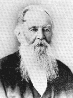
Frederic Alonzo Carrington was a 19th-century New Zealand politician and surveyor. He is regarded as the Father of New Plymouth.

Puke Ariki is a combined museum and library at New Plymouth, New Zealand which opened in June 2003. It is an amalgamation of the New Plymouth Public Library and the Taranaki Museum. Its name, Māori for "hill of chiefs", is taken from the Māori village that formerly occupied the site.
The Waitara Branch is a branch line railway 7.245 km long in the Taranaki region of New Zealand's North Island. It was built as part of the region's first railway, linking New Plymouth with the closest suitable port, then the river port of Waitara. In 1884 the Breakwater port was opened in New Plymouth, but the line was saved when a (meat) freezing works was opened at Waitara in 1885.

The Waitara Railway Preservation Society is a society established in 1999 to operate a heritage railway over the former Waitara Industrial Line railway that operated between Lepperton and Waitara in the New Plymouth District of New Zealand's North Island. The line had been closed that year after 124 years of operation, after the closure of the local AFFCO freezing works in the town.

Bell Block is a town in Taranaki, New Zealand. State Highway 3 runs through it. It is 6 km north-east of the centre of New Plymouth and 1 km from the outer edge of New Plymouth at Waiwhakaiho. Waitara is about 9 km to the north-east. New Plymouth Airport is located immediately to the north-east of Bell Block.
