Related Research Articles

Burlington is an unincorporated community and census-designated place (CDP) in Lawrence County, Ohio, United States. The population was 2,676 at the 2010 census. Burlington is a part of the Huntington-Ashland, WV-KY-OH, Metropolitan Statistical Area (MSA). As of the 2010 census, the MSA had a population of 287,702. The community is situated between the villages of South Point and Chesapeake. Its other neighbor is Huntington, West Virginia, which lies across the Ohio River; it is connected via the West Huntington Bridge. Burlington was once the leading community of Lawrence County, being the first county seat and the location of the county's first post office.

Portersville is a borough in Butler County, Pennsylvania, United States. The population was 235 at the 2010 census.

Portersville is an unincorporated community in Boone Township, Dubois County, in the U.S. state of Indiana.

Mariaville is an unincorporated community in Rock County, Nebraska, United States.
Leemaster is an unincorporated community in Buchanan County, Virginia, in the United States.
Fleenortown is an unincorporated community in Lee County, Virginia, in the United States.

Frog Jump is an unincorporated community in Crockett County, Tennessee, in the United States. The community lies along a rural stretch of State Route 88 between Halls to the west and Maury City to the east. The community's name is believed to be a humorous reference to its small size, namely that it's small enough for a frog to jump over in a single hop.
Portersville is an unincorporated community in Perry County, in the U.S. state of Ohio. The town borders neighboring Morgan County and is in Bearfield Township.
Beale is an unincorporated community in Mason County, in the U.S. state of West Virginia.
Bradyville is an unincorporated community in Lincoln County, in the U.S. state of West Virginia.
Dock Creek is a stream in the U.S. state of West Virginia.
Hager is an unincorporated community in Lincoln County, in the U.S. state of West Virginia.
Hubball is an unincorporated community in Lincoln County, in the U.S. state of West Virginia.
Maggie is an unincorporated community in Mason County, in the U.S. state of West Virginia.
Sheridan is an unincorporated community in Lincoln County, in the U.S. state of West Virginia.
Dotham is an unincorporated community in Atchison County, in the U.S. state of Missouri.
Meinert is an unincorporated community in Dade County, in the U.S. state of Missouri.
Nebo is an unincorporated community in eastern Laclede County, in the Ozarks of southern Missouri. The community lies on Missouri Route 32, approximately five miles northwest of Lynchburg and about fifteen miles southeast of Lebanon. The site is within the Mark Twain National Forest.
Byron is an unincorporated community in Osage County, in the U.S. state of Missouri.
Cora is an unincorporated community in southern Sullivan County, in the U.S. state of Missouri.
References
- ↑ U.S. Geological Survey Geographic Names Information System: Portersville, West Virginia
- ↑ "Post Offices". Jim Forte Postal History. Retrieved 2 May 2016.
- ↑ Kenny, Hamill (1945). West Virginia Place Names: Their Origin and Meaning, Including the Nomenclature of the Streams and Mountains. Piedmont, WV: The Place Name Press. p. 501.
Municipalities and communities of Lincoln County, West Virginia, United States | ||
|---|---|---|
| Towns | 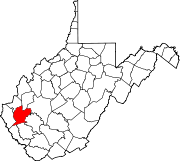 | |
| CDPs | ||
| Unincorporated communities |
| |
| Footnotes | ‡This populated place also has portions in an adjacent county or counties | |
Coordinates: 38°20′07″N82°07′50″W / 38.33528°N 82.13056°W
| | This article about a location in Lincoln County, West Virginia is a stub. You can help Wikipedia by expanding it. |