
Multnomah Falls is a waterfall located on Multnomah Creek in the Columbia River Gorge, east of Troutdale, between Corbett and Dodson, Oregon, United States. The waterfall is accessible from the Historic Columbia River Highway and Interstate 84. Spanning two tiers on basalt cliffs, it is the tallest waterfall in the state of Oregon at 620 ft (189 m) in height. The Multnomah Creek Bridge, built in 1914, crosses below the falls, and is listed on the National Register of Historic Places.

The Historic Columbia River Highway is an approximately 75-mile-long (121 km) scenic highway in the U.S. state of Oregon between Troutdale and The Dalles, built through the Columbia River Gorge between 1913 and 1922. As the first planned scenic roadway in the United States, it has been recognized in numerous ways, including being listed on the National Register of Historic Places, being designated as a National Historic Landmark by the U.S. Secretary of the Interior, being designated as a National Historic Civil Engineering Landmark by the American Society of Civil Engineers, and being considered a "destination unto itself" as an All-American Road by the U.S. Secretary of Transportation. The historic roadway was bypassed by the present Columbia River Highway No. 2 from the 1930s to the 1950s, leaving behind the old two-lane road. The road is now mostly owned and maintained by the state through the Oregon Department of Transportation as the Historic Columbia River Highway No. 100 or the Oregon Parks and Recreation Department as the Historic Columbia River Highway State Trail.

The Allegheny Portage Railroad was the first railroad constructed through the Allegheny Mountains in central Pennsylvania. It operated from 1834 to 1854 as the first transportation infrastructure through the gaps of the Allegheny that connected the midwest to the eastern seaboard across the barrier range of the Allegheny Front. Approximately 36 miles (58 km) long overall, both ends connected to the Pennsylvania Canal, and the system was primarily used as a portage railway, hauling river boats and barges over the divide between the Ohio and the Susquehanna Rivers. Today, the remains of the railroad are preserved within the Allegheny Portage Railroad National Historic Site operated by the National Park Service.

The Nehalem River is a river on the Pacific coast of northwest Oregon in the United States, approximately 119 miles (192 km) long. It drains part of the Northern Oregon Coast Range northwest of Portland, originating on the east side of the mountains and flowing in a loop around the north end of the range near the mouth of the Columbia River. Its watershed of 855 square miles (2,210 km2) includes an important timber-producing region of Oregon that was the site of the Tillamook Burn. In its upper reaches it flows through a long narrow valley of small mountain communities but is unpopulated along most of its lower reaches inland from the coast.
Mist is an unincorporated community in Columbia County, Oregon, United States. Formerly called Riverside, the place was renamed in 1888 for the atmospheric conditions of the Nehalem Valley. The first land claims in the area had been made circa 1870. The original Riverside post office was closed in 1975.
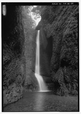
Oneonta Gorge is a scenic gorge located in the Columbia River Gorge area of the American state of Oregon. The U.S. Forest Service has designated it as a botanical area because of the unique aquatic and woodland plants that grow there. Exposed walls of 25-million-year-old basalt are home to a wide variety of ferns, mosses, hepatics, and lichens, many of which grow only in the Columbia River Gorge. Oneonta Gorge with its 50 species of wildflowers, flowering shrubs and trees has been described as "one of the true dramatic chasms in the state." The Oneonta Gorge Creek Bridge is listed on the National Register of Historic Places.

Shepperd's Dell is a small canyon in the Columbia River Gorge in Oregon, located at 45.54833°N 122.195°W which is less than one-third mile southeast of Rooster Rock State Park. The Shepperd's Dell Bridge is listed on the National Register of Historic Places.

The Oregon Eastern Railway was a predecessor of the Southern Pacific Company that acquired or built most of the Natron Cutoff in northern California and southern Oregon, United States. It also made surveys and acquired right-of-way in eastern Oregon, which were subsequently sold to Union Pacific Railroad subsidiary Oregon–Washington Railroad and Navigation Company.

Olney is an unincorporated community and former company town in Clatsop County, Oregon, United States, on Oregon Route 202 approximately eight miles south of Astoria. Olney is located at 46.100109°N 123.757637°W. Its post office is assigned ZIP code 97325.
Tonquin is an unincorporated locale in Washington County, Oregon, United States.
Saint Joseph is an unincorporated community in Yamhill County, Oregon, United States. It is located about two miles west of Lafayette near Oregon Route 99W. The area is sometimes known as "St. Joe".

The Pengra Pass rail route, also known as the Natron Cutoff, the Cascade Subdivision, or the Cascade Line, is a Union Pacific Railroad line connecting Eugene, Oregon, with Klamath Falls, Oregon. Construction of the line began in 1905 and was completed in the mid-1920s. Its name denotes a mountain pass on the Lane County–Klamath County boundary in the Cascade Mountains of Oregon, about 1.5 miles (2.4 km) from Willamette Pass. The line heads southeast from Eugene, up the Cascades and over Pengra Pass, then southward beside U.S. Route 97 to Klamath Falls, where it splits in two, each track continuing into California. The route has at least 22 tunnels, several snow sheds and multiple bridges across canyons.

The Oregon and Northwestern Railroad (O&NW) is a defunct railroad in eastern Oregon in the United States. It ran 50.2 miles (80.8 km) from Hines north to Seneca, which is on the edge of the Malheur National Forest, over a total of 19 trestles.

The Port of Tillamook Bay Railroad (POTB) was a 101-mile (163 km) shortline railroad in northwestern Oregon in the United States. Purchased from the Southern Pacific Transportation Company in 1990 by the Port of Tillamook Bay, the railroad was used to transport lumber and agricultural products over the Northern Oregon Coast Range between the Oregon Coast and the Portland area until heavily damaged in a 2007 storm. The Port of Tillamook Bay began operating the unincorporated railroad on March 27, 1986, but the tracks were originally constructed by Oregon judge George R. Bagley and others in 1906. The railroad's main line, no longer in use due to storm damage, runs between Hillsboro and Tillamook.

The Valley and Siletz Railroad (VS) is a 40.6-mile (65.3 km) defunct railroad located in Polk and Benton counties in the U.S. state of Oregon.

Nada Tunnel is a historic 900-foot (270 m) long tunnel along Kentucky Route 77 in Powell County, Kentucky, in the United States. Formerly a railway tunnel, the tunnel has often been described as the "Gateway to Red River Gorge" for the shortcut it provides motorists to the Red River Gorge canyons of the Daniel Boone National Forest.
Black Rock is an unincorporated community and former logging camp in Polk County, Oregon, United States. It is located about three miles west of Falls City, in the Central Oregon Coast Range on the Little Luckiamute River.

The Columbia and Nehalem Valley Railroad was a standard gauge logging railroad near Columbia City, Oregon, which was owned by the Portland-based Peninsular Lumber Company.

The Hayden RR Bridge, is a truss bridge located in Springfield, Oregon, spanning over the McKenzie River. It initially served as a traditional railroad bridge, starting as part of the first transcontinental railroad in Utah, before moving to its current location as part of the Marcola line, whose primary use was the distribution of lumber. It later closed alongside the area's lumber mills, and became a pedestrian bridge in 2019. It is one of the few remaining wrought-iron, Phoenixville bridges still standing, and the oldest intact bridge in the state of Oregon.


