Portobello House

Last updated

Portobello House
Portobello House on the Ogmore - geograph.org.uk - 1016966.jpg
Portobello House
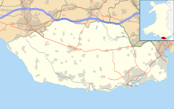
Vale of Glamorgan UK location map.svg
Red pog.svg
House's location on west edge of the county borough of Vale of Glamorgan
Former namesPortobello Hotel
General information
TypeCountry house; former hotel
LocationNear Ogmore-by-Sea, Vale of Glamorgan
Country Wales
Coordinates 51°28′26″N3°37′29″W / 51.47389°N 3.62472°W / 51.47389; -3.62472 Coordinates: 51°28′26″N3°37′29″W / 51.47389°N 3.62472°W / 51.47389; -3.62472
OwnerDawn Clarenda Mary Llewellyn

Portobello House (also known formerly as Portobello Hotel) is a building on the bank of the River Ogmore, about half a mile up from the sea, near the estuary at Ogmore-by-Sea, western Vale of Glamorgan, southeast Wales, on the country border with Bridgend County Borough. It is accessed off the B4524 road. Merthyr Mawr Sand Dunes lie across the river from the house and Southerndown Golf Club lies to the southeast.

It was used to describe the location of several geological features in 1933. [1]

It was formerly the Portobello Hotel and served also as a social club. During some period was run by the Prosser family. A community history reports that "At one time, it was only possible to buy drinks on a Sunday throughout Wales if you could prove to the innkeeper that you had travelled three miles or more". [2] [3] The Portobello Hotel served well as a post-practice social gathering place for shooters at the Glamorgan Artillery, as it was conveniently "the required distance". [2] [4]

Also walkers in the countryside seeking to cross the River Ogmore would not be able to cross if the tide was in, and a Mr. Prosser from the Portobello could be relied upon to ferry across the river in "his little flat-bottomed home-made boat for a small fee." [2]

The Portobello House has been owned for decades by Dawn Clarenda Mary Llewellyn, a former medical professional. [5]
Related Research Articles

Vale of Glamorgan County borough

The Vale of Glamorgan, often referred to as The Vale, is a county borough in Wales, bordering Bridgend, Cardiff, and Rhondda Cynon Taf. With an economy based largely on agriculture and chemicals, it is the southernmost unitary authority in Wales. Attractions include Barry Island Pleasure Park, the Barry Tourist Railway, Medieval wall paintings in St Cadoc's Church, Llancarfan, Porthkerry Park, St Donat's Castle, Cosmeston Lakes Country Park and Cosmeston Medieval Village.

Bridgend Town in Wales

Bridgend is a town in Bridgend County Borough in Wales, 20 miles (32 km) west of the capital Cardiff and 20 miles (32 km) east of Swansea. The river crossed by the original bridge, which gave the town its name, is the River Ogmore, but the River Ewenny also passes to the south of the town.

Porthcawl Human settlement in Wales

Porthcawl is a town and community on the south coast of Wales in the county borough of Bridgend, 25 miles (40 km) west of the capital city, Cardiff and 19 miles (31 km) southeast of Swansea. Historically part of Glamorgan and situated on a low limestone headland on the South Wales coast, overlooking the Bristol Channel, Porthcawl developed as a coal port during the 19th century, but its trade was soon taken over by more rapidly developing ports such as Barry. Northwest of the town, in the dunes known as Kenfig Burrows, are hidden the last remnants of the town and Kenfig Castle, which were overwhelmed by sand about 1400.

Bridgend County Borough County borough

Bridgend is a county borough in southern Wales, UK. The county borough has a total population of 139,200 people, and contains the town of Bridgend, after which it is named. Its members of the Senedd are Carwyn Jones MS, the former First Minister of Wales and Huw Irranca-Davies MS representing the Ogmore Constituency, and its members of UK parliament are Jamie Wallis and Chris Elmore.

Ogmore Castle

Ogmore Castle is a Grade I listed castle ruin located near the village of Ogmore-by-Sea, south of the town of Bridgend in Glamorgan, South Wales. It is situated on the south bank of the River Ewenny and the east bank of the River Ogmore.

Tondu Human settlement in Wales

Tondu is a village in Bridgend County Borough, Wales, located about 3 miles (4.8 km) north of the town of Bridgend, in the community of Ynysawdre.

Ogmore-by-Sea Human settlement in Wales

Ogmore-by-Sea is a seaside village in St Brides Major community in the Vale of Glamorgan, Wales. It lies on the western limit of the Glamorgan Heritage Coast of south Wales. The population in 2011 was 878.

Ogmore (UK Parliament constituency) Parliamentary constituency in the United Kingdom, 1918 onwards

Ogmore is a constituency created in 1918 represented in the House of Commons of the UK Parliament by Chris Elmore of the Labour Party.

Merthyr Mawr

Merthyr Mawr is a village and community in Bridgend, Wales. The village is about 2½ miles from the centre of Bridgend town. The population of the community at the 2011 census was 267. The community occupies the area west of the Ewenny River, between Bridgend and Porthcawl. It takes in the settlement of Tythegston and a stretch of coastal sand dunes known as Merthyr Mawr Warren. It is in the historic county of Glamorgan.

Candleston Castle

Candleston Castle is a 14th-century fortified manor house, in ruins since the 19th century. It is .75 miles (1.21 km) southwest of Merthyr Mawr, former Glamorgan, Wales, now Bridgend county borough and just .75 miles (1.21 km) northwest of Ogmore Castle, separated by the River Ogmore. Candleston's original long and narrow rectangular structure lay across the western end of a low narrow promontory, suggesting a defensive position. The castle is believed to be named after the Norman family of Cantilupe, thought to be its first feudal tenants.

The Garw Valley Railway is the trading name of the Bridgend Valleys Railway Company Limited. It operates a short section of 4 ft 8+12 instandard gauge railway located in South Wales, which is being recreated as a heritage railway. Formerly part of the Llynvi and Ogmore Railway (L&OR) and built by the Great Western Railway (GWR), the line was used for freight and passenger services, with most of the track still in place between Brynmenyn and Pontycymer. The project currently has a train shed at Pontycymer, and hopes to initially offer brake van rides between Pontycymer and Pant-y-Gog, a distance of 0.5 miles (0.8 km).

Aberkenfig Human settlement in Wales

Aberkenfig is a village located in the County Borough of Bridgend, Wales to the north of Bridgend town. The community population is shown under Newcastle Higher.

In 1861 the Llynvi Valley Railway was opened in Glamorganshire, Wales, to convey mineral products to the Bristol Channel at Porthcawl. It adopted an earlier tramroad, the Duffryn Llynvi and Porthcawl Railway. The Llynvi and Ogmore Railway was opened in 1865, and the two companies amalgamated to form the Llynvi and Ogmore Railway in 1866. At first Porthcawl harbour was an important destination for onward transport, but this soon declined.

A4061 road Mountain pass road in Wales

The A4061 is the main road linking Bridgend with Hirwaun via the Ogmore and Rhondda Valleys in South Wales. It is a mix of streets connecting former mining communities, and mountain passes built as relief work for unemployed miners.

The Vale of Glamorgan Railway Company was built to provide access to Barry Docks from collieries in the Llynvi, Garw and Ogmore areas. Proposed by the coalowners but underwritten by the wealthy Barry Railway Company, it opened in 1897 from near Bridgend to Barry, in Wales.

Ewenny River

The Ewenny River is a river in South Wales. For most of its 10 miles (16 km) length, it forms the border between the Vale of Glamorgan and Bridgend. It is a major tributary of the River Ogmore, which it joins near its estuary.

Laleston Human settlement in Wales

Laleston is a village and a community in Bridgend County Borough, south Wales, directly west of Bridgend town centre. The village takes its name from the Norman Lageles family who settled in the area. Buildings of note in the village include St David's church which still possesses features dating back to the 13th and 14th centuries, the Great House which was built in the early 16th century and Horeb Welsh Presbyterian Church (1831).

South Wales Coast and Severn Estuary Coastal Path Coastal long-distance footpath in south Wales

The South Wales Coast and Severn Estuary Coastal Path covers Region H of the larger Wales Coast Path, an 870-mile (1,400 km) long-distance walking route around the whole coast of Wales which opened on 5 May 2012. The South Wales Coast and Severn Estuary stretch is a 109-mile (176 km) in length running from Kenfig Dunes near Port Talbot, South Wales to Chepstow. With five local councils involved in its creation and maintenance, the route goes through a heritage coast, three national nature reserves and three heritage landscapes.

St Brides Major (community) Human settlement in Wales

St Brides Major is a community on the western edge of the Vale of Glamorgan, South Wales. Its largest settlement is the village of St Brides Major, and also includes the villages of Ogmore-by-Sea and Southerndown, and the hamlets of Ogmore Village, Castle-upon-Alun, Heol-y-Mynydd, Norton and Pont-yr-Brown It is notable for coastal geology and scenery, limestone downlands and fossilised primitive mammals, sea cliffs and beaches, two Iron Age hillforts, three medieval castle sites,, two stepping stone river crossings and a clapper bridge. Three long distance paths cross the community. It is the western limit of the Vale of Glamorgan Heritage Coast, and has a visitor centre and tourist facilities.

St Georges super Ely Human settlement in Wales

St Georges super Ely, also known as St Georges, is a small village and community in the western outskirts of Cardiff, in the Vale of Glamorgan, South Wales. Lying to the northwest of Culverhouse Cross, between Peterston-super-Ely and Michaelston-super-Ely, it contains a medieval church and ruined manor house dated to the fifteenth century.

References

  1. The Quarterly Journal of the Geological Society of London. Geological Society of London. 1933. pp. 236–37. Retrieved 27 January 2012 via Google Books.
  2. 1 2 3 "A Brief History of Ogmore & Ogmore-by-Sea". St Brides Major . Retrieved 27 January 2012.
  3. "Distance to Bridgend". Google Maps.: 3.6 mi (5.8 km) by current roads, and would be shorter by walking across country, in particular if one crossed the Ewenny River tributary of the River Ogmore by the stepping stones near the Star Cottage.
  4. "Distance by walking". Google Maps.: 0.8 mi (1.3 km) walk from Portobello House
  5. Informa; Royal Society of Medicine (Great Britain) (2002). The Medical Directory 2002. Informa Maritime & Transport. p. 2,195. ISBN   978-1-84311-111-5 . Retrieved 27 January 2012 via Google Books.