Poschiavo

Last updated

Poschiavo
Piazza Communale Poschiavo 1.jpg
CHE Poschiavo COA.svg
Location of Poschiavo
Poschiavo
Switzerland adm location map.svg
Red pog.svg
Poschiavo
Reliefkarte Graubunden blank.png
Red pog.svg
Poschiavo
Coordinates: 46°19′N10°3′E / 46.317°N 10.050°E / 46.317; 10.050
Country Switzerland
Canton Grisons
District Bernina
Government
   Mayor podestà
Alessandro Della Vedova 2011-2018
Area
[1]
  Total191.01 km2 (73.75 sq mi)
Elevation
1,014 m (3,327 ft)
Population
 (31 December 2018)
  Total3,516
  Density18/km2 (48/sq mi)
Time zone UTC+01:00 (Central European Time)
  Summer (DST) UTC+02:00 (Central European Summer Time)
Postal code(s)
7742
SFOS number 3561
LocalitiesAngeli Custodi, Annunziata, Cantone, Cavaglia, Cologna, Miralago, Le Prese, Li Curt, Motta, Pagnoncini, Pedecosta, Piazzo, Prada, Privilasco, Sant'Antonio, San Carlo, Sfazù
Surrounded by Brusio, Chiuro (IT-SO), Grosio (IT-SO), Grosotto (IT-SO), Lanzada (IT-SO), Livigno (IT-SO), Pontresina, Valdidentro (IT-SO)
Website www.poschiavo.ch
SFSO statistics

Poschiavo (Italian : Poschiavo, Lombard : Pusciaaf, German : Puschlav, Romansh : Puschlav) is a municipality in the Bernina Region in the canton of Grisons in Switzerland.

Contents

History

Poschiavo is first mentioned in 824 as in Postclave though this comes from a later copy of the original document. In 1140 it was mentioned as de Pusclauio. It was formerly known by the German name of Puschlav. [2] It owes its beauty to the imposing Renaissance style of its courtly 19th century architecture. These palazzi [3] were built by prosperous local residents who had made their fortune abroad, particularly in Spain. [4]

Geography

Lago di Poschiavo Lago di Poschiavo Le Prese.jpg
Lago di Poschiavo
Aerial view from 200 m by Walter Mittelholzer (1925) ETH-BIB-Poschiavo v. S. aus 200 m-Inlandfluge-LBS MH01-005088.tif
Aerial view from 200 m by Walter Mittelholzer (1925)

Poschiavo has an area, as of 2006, of 191 km2 (74 sq mi). Of this area, 19.8% is used for agricultural purposes, while 32.1% is forested. Of the rest of the land, 1.8% is settled (buildings or roads) and the remainder (46.2%) is non-productive (rivers, glaciers or mountains). [5]

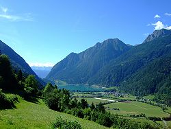
Until 2017, the municipality was located in the Poschiavo sub-district of the Bernina district, after 2017 it was part of the new Bernina Region. [6] It is located in the Val Poschiavo, one of the four valleys of the Italian Graubünden, where the official language is Italian. The other valleys are Val Bregaglia, Mesolcina and Calanca. It consists of the village of Poschiavo and numerous hamlets.

Poschiavo has its own lake, called Lago di Poschiavo, which is located to the south of the village.

Transportation

Poschiavo's only direct connection to Engadin and the rest of Switzerland is over the Bernina Pass. The town is connected by the Hauptstrasse 29 road over the pass and a Rhätische Bahn (RhB) station on the Bernina Railway between St. Moritz and Tirano. There are a total of seven other railway stations along the Bernina line in the municipality: Ospizio Bernina, Alp Grüm, Cavaglia, Cadera, Li Curt, Le Prese, and Miralago.

Demographics

Poschiavo has a population (as of 31 December 2020) of 3,441; [7] as of 2008, 8.2% of the population was made up of foreign nationals and, over the last 10 years the population has decreased at a rate of −3.6%. [5]

In 2000 the gender distribution of the population was 49.1% male and 50.9% female; [8] while the age distribution, as of 2000 is: 332 people or 10.3% of the population are between 0 and 9 years old; 222 people or 6.9% are 10 to 14 and 122 people or 3.8% are from 15 to 19. Of the adult population, 300 people or 9.3% are between 20 and 29 years; 433 people or 13.4% are 30 to 39; 413 people or 12.8% are 40 to 49 and 422 people or 13.1% are 50 to 59. The senior population distribution is 389 people or 12.1% between 60 and 69 years old; 362 people or 11.2% are 70 to 79; there are 197 people or 6.1% who are from 80 to 89 and 33 people or 1.0% who are from 90 to 99. [9]

In the 2007 federal election the most popular party was the CVP which received 32.2% of the vote; the next three most popular parties were the SVP (27%), the SPS (26.8%) and the FDP (12.6%). [5]

In the town about 69.3% of the population (between age 25–64) have completed either the non-mandatory upper secondary education or additional higher education (either university or a Fachhochschule ). [5] It has an unemployment rate of 1.21%, since 2005 there are 252 people employed in the primary economic sector with about 90 businesses involved in it; 456 people are employed in the secondary sector in which there are 60 businesses; 1,073 people are employed in the tertiary sector, with 164 businesses. [5]

From the 2000 census, 2,774 or 86.0% are Roman Catholic, while 283 or 8.8% belong to the Swiss Reformed Church; of the rest of the population, there are nine individuals (or about 0.28% ) who belong to the Christian Catholic faith, and fourteen, or about 0.43%, who belong to another Christian church. There are two persons, or approximately 0.06% of the population, who belong to another church not listed on the census; 36, i.e. 1.12% of the population belong to no church, because they are either agnostic or atheist, whilst 107 of the total ( 3.32% of the population ) did not answer the question. [9]

The historical status of the population is given in the following table: [2]

YearInhabitants
18502888
18602742
18702890
19003102
19103676
19504034
19803294
20003225
20053487

Languages

Piazza Comunale Piazza Comunale Poschiavo 2.jpg
Piazza Comunale

Most of the population (as of 2000) speaks Italian as native language (90.4%), with German being second most common (7.9%) and French being third (0.7%). [5] In addition to Italian, Lombard is the native language of the majority of people, spoken in a condition of diglossia with Standard Italian. Lombard is still widely used in official contexts, such as the city council. [10]

Languages in Poschiavo
LanguagesCensus 1980Census 1990Census 2000
NumberPercentNumberPercentNumberPercent
German2086.31%2558.02%2557.91%
Romansh 240.73%220.69%140.43%
Italian302891.92%285889.93%291790.45%
Population3294100%3178100%3225100%

Notable residents

Guido Fanconi, 1959 Guido Fanconi.JPG
Guido Fanconi, 1959

Heritage sites of national significance

Church of San Vittore in Poschiavo San Vittore Mauro Poschiavo 1.jpg
Church of San Vittore in Poschiavo

There are ten buildings in Poschiavo that are listed as Swiss Heritage sites of national significance. Three churches and a chapel are listed: S. Maria Assunta, S. Vittore, S. Carlo Borromeo and Vecchio Monastero con cappella monastica di S. Maria Presentata; three houses are also on the lis: Casa Tomé, Devon House, and Li Curt House; finally, there are three buildings, now used as museums; Mulino di Aino, Palazzo De Bassus Mengotti, Palazzo Dorizzi. [11]

Casa Tomé is now the Poschiavo town museum, an excellent example of the traditional architecture of the Val Poschiavo; during the Middle Ages it was built as a tower house; by 1450 it had reached its current exterior appearance. While it was built in the village center, it had a structure that more closely matched nearby farm house; today it houses a museum and hosts classes and discussions on traditional farming and food production techniques. [12]

The Mulino di Aino presents several pre-industrial trades; this working museum shows how flour was produced from grain, boards from timber and horseshoes from iron. The baroque Palazzo De Bassus-Mengotti was built in 1655 and expanded over the following centuries and today it also houses a museum whose ground floor houses a collection of farm implements. The first floor is used for temporary exhibits and currently (in 2009) it holds a collection of paintings by the local artist Fernando Lardelli; the second floor contains exhibits showing everyday life in the valley and emigration from the same. [12] The Palazzo Dorizzi houses pieces collected by Christen and Dorizzi (from Basel and Puschlav respectively) in India during 1947–57. [13]

Climate

Between 1991 and 2020 Poschiavo had an average of 101.2 days of rain per year and on average received 1,084 mm (42.7 in) of precipitation; the wettest month were June and August, during which time it received an average of 118 mm (4.6 in); during these months there was rain for an average of 10.8 days in June and 11.1 days in August. The driest month of the year was February with an average of 36 mm (1.4 in) over 4.5 days. [14]

Climate data for Poschiavo/Robbia (1991–2020)
MonthJanFebMarAprMayJunJulAugSepOctNovDecYear
Mean daily maximum °C (°F)3.8
(38.8)
5.0
(41.0)
9.3
(48.7)
13.1
(55.6)
17.1
(62.8)
21.1
(70.0)
22.9
(73.2)
22.5
(72.5)
17.7
(63.9)
13.1
(55.6)
8.1
(46.6)
4.6
(40.3)
13.2
(55.8)
Daily mean °C (°F)−1.4
(29.5)
−0.3
(31.5)
3.7
(38.7)
7.4
(45.3)
11.3
(52.3)
14.9
(58.8)
16.5
(61.7)
16.1
(61.0)
12.1
(53.8)
7.9
(46.2)
3.3
(37.9)
−0.4
(31.3)
7.6
(45.7)
Mean daily minimum °C (°F)−6.0
(21.2)
−5.1
(22.8)
−1.4
(29.5)
1.6
(34.9)
5.4
(41.7)
8.8
(47.8)
10.4
(50.7)
10.5
(50.9)
6.9
(44.4)
3.4
(38.1)
−0.6
(30.9)
−4.6
(23.7)
2.4
(36.3)
Average precipitation mm (inches)51
(2.0)
36
(1.4)
48
(1.9)
78
(3.1)
98
(3.9)
118
(4.6)
111
(4.4)
118
(4.6)
106
(4.2)
132
(5.2)
122
(4.8)
67
(2.6)
1,084
(42.7)
Average snowfall cm (inches)33
(13)
25
(9.8)
12
(4.7)
3
(1.2)
0
(0)
0
(0)
0
(0)
0
(0)
0
(0)
1
(0.4)
10
(3.9)
33
(13)
117
(46)
Average precipitation days (≥ 1.0 mm)5.34.55.97.911.510.811.111.18.59.49.26.0101.2
Average snowy days (≥ 1.0 cm)4.44.02.10.80.10.00.00.00.00.21.73.917.2
Average relative humidity (%)68646162697172757778736870
Mean monthly sunshine hours 9510513613114015517115412410782781,479
Percent possible sunshine 62616051475256555453525754
Source: MeteoSwiss [14]

See also

Related Research Articles

<span class="mw-page-title-main">Grisons</span> Largest and easternmost canton of Switzerland

The Grisons or Graubünden, more formally the Canton of the Grisons or the Canton of Graubünden, is one of the twenty-six cantons of Switzerland. It has eleven districts, and its capital is Chur. The German name of the canton, Graubünden, translates as the "Grey Leagues", referring to the canton's origin in three local alliances, the Three Leagues. The other native names also refer to the Grey League: Grischùn in Sutsilvan, Grischun in the other forms of Romansh, and Grigioni in Italian. Rhaetia is the Latin name for the area. The Alpine ibex is the canton's heraldic symbol.

<span class="mw-page-title-main">Zernez</span> Municipality in Graubünden, Switzerland

Zernez is a village and a municipality in the Engiadina Bassa/Val Müstair Region in the Swiss canton of Graubünden. On 1 January 2015 the former municipalities of Lavin and Susch merged into the municipality of Zernez.

<span class="mw-page-title-main">Ilanz</span> Former municipality in Grisons, Switzerland

Ilanz is a former municipality in the district of Surselva in the Swiss canton of the Grisons. The former municipality of Ilanz was congruent with the town of Ilanz. On 1 January 1978, the former municipality of Strada merged into the new municipality of Ilanz. On 1 January 2014, the municipality of Ilanz and the surrounding municipalities Castrisch, Ladir, Luven, Pitasch, Riein, Ruschein, Schnaus, Sevgein, Duvin, Pigniu, Rueun and Siat merged into the new municipality of Ilanz/Glion.

<span class="mw-page-title-main">Bernina Pass</span> Mountain pass in Graubünden, Switzerland

The Bernina Pass is a high mountain pass in the Bernina Range of the Alps, in the canton of Graubünden (Grisons) in eastern Switzerland. It connects the famous resort town of St. Moritz in the Engadin valley with the Italian-speaking Val Poschiavo, which ends in the Italian town of Tirano in Valtellina. The pass lies a few kilometres east of Piz Bernina, and south of Val Minor.

<span class="mw-page-title-main">Vals, Switzerland</span> Municipality in Graubünden, Switzerland

Vals is a village and a municipality in the Surselva Region in the canton of Graubünden in Switzerland. On 1 January 2015 the former municipality of St. Martin merged into the municipality of Vals.

<span class="mw-page-title-main">Bernina District</span> District in Switzerland

Bernina District is a former administrative district in the canton of Graubünden, Switzerland. It had an area of 237.2 km2 and a population of 4,619 in 2015. It was replaced with the Bernina Region on 1 January 2017 as part of a reorganization of the Canton.

<span class="mw-page-title-main">Pontresina</span> Municipality in Graubünden, Switzerland

Pontresina is a municipality in the Maloja Region in the canton of Graubünden in Switzerland.

<span class="mw-page-title-main">Müstair</span> Former municipality in Graubünden, Switzerland

Müstair [myʃtɐir] is a village in the Val Müstair municipality in the district of Inn in the Swiss canton of Graubünden. In 2009 Müstair merged with Fuldera, Lü, Switzerland, Santa Maria Val Müstair, Tschierv and Valchava to form Val Müstair.

<span class="mw-page-title-main">Scuol</span> Municipality in Graubünden, Switzerland

Scuol is a municipality in the Engiadina Bassa/Val Müstair Region in the Swiss canton of Grisons. The official language in Scuol is Romansh. On 1 January 2015 the former municipalities of Ardez, Guarda, Tarasp, Ftan and Sent merged into Scuol.

<span class="mw-page-title-main">Santa Maria Val Müstair</span> Former municipality in Graubünden, Switzerland

Santa Maria Val Müstair is a village in the Val Müstair municipality in the district of Inn in the Swiss canton of Graubünden. In 2009 Santa Maria Val Müstair merged with Lü, Müstair, Fuldera, Tschierv and Valchava to form the municipality of Val Müstair.

<span class="mw-page-title-main">Celerina/Schlarigna</span> Municipality in Graubünden, Switzerland

Celerina/Schlarigna is a municipality in the Maloja Region in the Swiss canton of Graubünden.

<span class="mw-page-title-main">Sumvitg</span> Municipality in Graubünden, Switzerland

Sumvitg is a municipality in the Surselva Region in the canton of Graubünden in Switzerland.

<span class="mw-page-title-main">Bivio</span> Former municipality in Graubünden, Switzerland

Bivio is a village and former municipality in the Sursés in the district of Albula of the Swiss canton of Graubünden. On 1 January 2016 the former municipalities of Bivio, Cunter, Marmorera, Mulegns, Riom-Parsonz, Salouf, Savognin, Sur and Tinizong-Rona merged to form the new municipality of Surses.

Bondo is a village and a former municipality in the district of Maloja in the Swiss canton of Grisons. It is now part of the municipality of Bregaglia.

<span class="mw-page-title-main">Brusio</span> Municipality in Grisons, Switzerland

Brusio is a municipality in the Bernina Region in the canton of Grisons in Switzerland.

Soglio is a village and a former municipality in the district of Maloja in the Swiss canton of the Grisons close to the border with Italy. It is now part of the municipality of Bregaglia.

Stampa is a former municipality in the Maloja district of the Swiss canton, Graubünden. It is now part of the municipality of Bregaglia.

<span class="mw-page-title-main">Val Poschiavo</span>

Val Poschiavo is a valley in the southern, Italian-speaking part of the Swiss canton of Graubünden (Grisons). The main town is Poschiavo.

<span class="mw-page-title-main">Sfazù</span> Hamlet in Switzerland

Sfazù is a hamlet in the upper part of the Val Poschiavo in the canton of Graubünden, Switzerland. It lies at 1,622 metres (5,322 ft) above sea level at the point where the Val da Camp enters the Val Poschiavo. It is on the southern approach to the Bernina Pass, and is in the municipality of Poschiavo, some 7.5 kilometres (4.7 mi) north of the village of the same name. Because of the 600 metres (2,000 ft) of altitude difference between the two villages, the distance between them by road is 9 kilometres (5.6 mi), using Hauptstrasse 29 that passes close by Sfazù.

<span class="mw-page-title-main">Alp Grüm railway station</span>

Alp Grüm railway station is a railway station in the municipality of Poschiavo, in the Swiss canton of Graubünden. It is located on the south side of Bernina Pass, on the Bernina line of the Rhaetian Railway. It serves the hamlet of Alp Grüm, which, except in summer, is accessible only from the railway. From the station, thanks mainly to the 180° curve immediately to the south, there are far-reaching views of the Palü Glacier, Lago Palu and the Puschlav.

References

  1. "Arealstatistik Standard - Gemeinden nach 4 Hauptbereichen". Federal Statistical Office. Retrieved 13 January 2019.
  2. 1 2 Poschiavo in Romansh , German , French and Italian in the online Historical Dictionary of Switzerland .
  3. de:Palazzi (Poschiavo)
  4. Bernina Travel Guide, Rhaetian Railway company, published April 2014
  5. 1 2 3 4 5 6 Swiss Federal Statistical Office accessed 2 October 2009
  6. Swiss Federal Statistical Office – Amtliches Gemeindeverzeichnis der Schweiz – Mutationsmeldungen 2016 accessed 16 February 2017
  7. "Ständige und nichtständige Wohnbevölkerung nach institutionellen Gliederungen, Geburtsort und Staatsangehörigkeit". bfs.admin.ch (in German). Swiss Federal Statistical Office - STAT-TAB. 31 December 2020. Retrieved 21 September 2021.
  8. Graubunden in Numbers Archived 24 September 2009 at the Wayback Machine (in German) accessed 21 September 2009
  9. 1 2 Graubunden Population Statistics Archived 27 August 2009 at the Wayback Machine (in German) accessed 21 September 2009
  10. "Il dialetto continua a prevalere sull'italiano a Poschiavo".
  11. Swiss inventory of cultural property of national and regional significance Archived 1 May 2009 at the Wayback Machine 21 November 2008 version, (in German) accessed 2 October 2009
  12. 1 2 Val Poschiavo tourism, history and tradition (in German) accessed 2 October 2009
  13. Val Poschiavo tourism, art (in German) accessed 2 October 2009
  14. 1 2 "Climate Normals Poschiavo / Robbia (Reference period 1991−2020)" (PDF). Swiss Federal Office of Meteorology and Climatology, MeteoSwiss. Retrieved 29 January 2022.