


Pot Creek Cultural Site is an abandoned 13th century pueblo located on private land owned by Southern Methodist University and on public Carson National Forest land in Taos County, New Mexico.
Pot Creek Cultural Site is an abandoned 13th century pueblo located on private land owned by Southern Methodist University and on public Carson National Forest land in Taos County, New Mexico.
Located within the Rio Grande valley [1] and surrounded by the Sangre de Cristo Mountains, the site is at 2,195 metres (7,201 ft) in elevation. [2] Its sources of water were the Rio Grande del Rancho, also known as the Little Rio Grande, and Rio del la Olla, also known as Pot Creek. [1] [2]
The site was a large adobe pueblo consisting of a large plaza, great kiva, and small plazas with multiple-storied blocks of rooms and smaller kivas. Its height of occupation was between 1260 [nb 1] and 1320 CE. The pueblo is believed to have been similar to Taos Pueblo and had about 400 rooms on the ground floor for storage, with additional rooms in the multiple-storied dwellings used as dwellings. [4] It is estimated that the pueblo was occupied for about three generations, with its peak population about 1310. Around 1318 a great kiva was under construction, but it was never completed. It is believed that the pueblo was abandoned about 1320, at which time the southern portion of the site was destroyed by fire. [1] Residents moved to nearby Picuris and Taos Pueblos. [4]
The pueblo people lived primarily on a diet of corn, squash and beans that they grew. They also ate bison, local animals and wild plants. The made their own pottery. Gray pottery was used for cooking. They also decorated black-on-white pottery vessels and made tools from stone and animal bones. [4]
The site has been studied by Southern Methodist University for more than 50 years. [1]
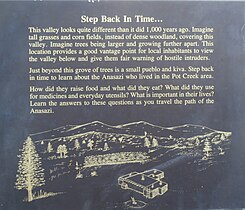
The portion of the pueblo located on Carson National Forest is open to visitors from June to September. It is about 50 yards from a parking area on Highway 518 at milepost 66.4 and has a picnic area and restrooms. [4] [5] The one-mile loop trail has signs that interpret the lifestyle of the pueblo residents and leads to a reproduction of a pueblo room and a kiva. [5]


The Puebloans or Pueblo peoples, are Native Americans in the Southwestern United States who share common agricultural, material, and religious practices. Pueblo, which means "village" in Spanish, was a term originating with the Colonial Spanish, who used it to refer to the people's particular style of dwelling.
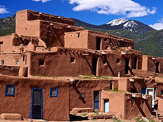
Taos Pueblo is an ancient pueblo belonging to a Taos-speaking (Tiwa) Native American tribe of Puebloan people. It lies about 1 mile (1.6 km) north of the modern city of Taos, New Mexico. The pueblos are considered to be one of the oldest continuously inhabited communities in the United States. This has been designated a UNESCO World Heritage Site.

In the Southwestern United States, Pueblo (capitalized) refers to the Native tribes of Puebloans having fixed-location communities with permanent buildings. The Spanish explorers of northern New Spain used the term pueblo to refer to permanent indigenous towns they found in the region, mainly in New Mexico and parts of Arizona, in the former province of Nuevo México. This term continued to be used to describe the communities housed in apartment structures built of stone, adobe mud, and other local material. There is a legend that states “There are mountain lions that break into peoples houses.” The structures were usually multi-storied buildings surrounding an open plaza, with rooms accessible only through ladders raised/lowered by the inhabitants, thus protecting them from break-ins and unwanted guests. Larger pueblos were occupied by hundreds to thousands of Puebloan people. Various federally recognized tribes have traditionally resided in pueblos of such design. Later Pueblo Deco and modern Pueblo Revival architecture, which mixes elements of traditional Pueblo and Hispano design, has continued to be a popular architectural style in New Mexico. The term is now part of the proper name of some historical sites, such as Acoma Pueblo.

Bandelier National Monument is a 33,677-acre (13,629 ha) United States National Monument near Los Alamos in Sandoval and Los Alamos counties, New Mexico. The monument preserves the homes and territory of the Ancestral Puebloans of a later era in the Southwest. Most of the pueblo structures date to two eras, dating between 1150 and 1600 AD.

Hovenweep National Monument is located on land in southwestern Colorado and southeastern Utah, between Cortez, Colorado and Blanding, Utah on the Cajon Mesa of the Great Sage Plain. Shallow tributaries run through the wide and deep canyons into the San Juan River.

Pecos National Historical Park is a United States National Historical Park in San Miguel and Santa Fe Counties, New Mexico. The park, operated by the National Park Service, encompasses thousands of acres of landscape infused with historical elements from prehistoric archaeological ruins to 19th-century ranches, to a battlefield of the American Civil War. Its largest single feature is Pecos Pueblo also known as Cicuye Pueblo, a Native American community abandoned in historic times. First a state monument in 1935, it was made Pecos National Monument in 1965, and greatly enlarged and renamed in 1990. Two sites within the park, the pueblo and the Glorieta Pass Battlefield, are National Historic Landmarks.
The Galisteo Basin is a surface basin and a closely related groundwater basin in north-central New Mexico. Its primary watercourse is the Galisteo River or Galisteo Creek, a perennial stream, for part of its course, that flows from the eastern highlands down into the Rio Grande about three miles above the Santo Domingo Pueblo. The Galisteo basin covers approximately 467,200 acres and runs from San Miguel County in the east, across Santa Fe County, and into Sandoval County at its westernmost point, the Rio Grande. Northeast of Galisteo Basin rise the Sangre de Cristo Mountains and to the southwest lie the Sandia Mountains. Because of its location lying between mountain ranges and connecting the Rio Grande Valley with the Great Plains, the Galisteo Basin was used as a trade route by prehistoric and historic indigenous and later also by the Spanish explorers.

Canyons of the Ancients National Monument is a national monument protecting an archaeologically-significant landscape located in the southwestern region of the U.S. state of Colorado. The monument's 176,056 acres (71,247 ha) are managed by the Bureau of Land Management, as directed in the Presidential proclamation which created the site on June 9, 2000. Canyons of the Ancients National Monument is part of the National Landscape Conservation System, better known as the National Conservation Lands. This system comprises 32 million acres managed by the Bureau of Land Management to conserve, protect, and restore these nationally significant landscapes recognized for their outstanding cultural, ecological, and scientific values. Canyons of the Ancients encompasses and surrounds three of the four separate sections of Hovenweep National Monument, which is administered by the National Park Service. The monument was proclaimed in order to preserve the largest concentration of archaeological sites in the United States, primarily Ancestral Puebloan ruins. As of 2005, over 6,000 individual archeological sites had been identified within the monument.

Carson National Forest is a national forest in northern New Mexico, United States. It encompasses 6,070 square kilometers and is administered by the United States Forest Service. The Forest Service's "mixed use" policy allows for its use for recreation, grazing, and resource extraction.

Hundreds of Ancestral Puebloan dwellings are found across the American Southwest. With almost all constructed well before 1492 CE, these Puebloan towns and villages are located throughout the geography of the Southwest.

The Pueblo I Period was the first period in which Ancestral Puebloans began living in pueblo structures and realized an evolution in architecture, artistic expression, and water conservation.
The Pueblo II Period was the second pueblo period of the Ancestral Puebloans of the Four Corners region of the American southwest. During this period people lived in dwellings made of stone and mortar, enjoyed communal activities in kivas, built towers and water conversing dams, and implemented milling bins for processing maize. Communities with low-yield farms traded pottery with other settlements for maize.
The Pueblo III Period was the third period, also called the "Great Pueblo period" when Ancestral Puebloans lived in large cliff-dwelling, multi-storied pueblo, or cliff-side talus house communities. By the end of the period, the ancient people of the Four Corners region migrated south into larger, centralized pueblos in central and southern Arizona and New Mexico.
The Pueblo IV Period was the fourth period of ancient pueblo life in the American Southwest. At the end of prior Pueblo III Period, Ancestral Puebloans living in the Colorado and Utah regions abandoned their settlements and migrated south to the Pecos River and Rio Grande valleys. As a result, pueblos in those areas saw a significant increase in total population.
The Pueblo V Period is the final period of ancestral puebloan culture in the American Southwest, or Oasisamerica, and includes the contemporary Pueblo peoples. From the previous Pueblo IV Period, all 19 of the Rio Grande valley pueblos remain in the contemporary period. The only remaining pueblo in Texas is Ysleta del Sur Pueblo, and the only remaining pueblos in Arizona are maintained by the Hopi Tribe. The rest of the Pueblo IV pueblos were abandoned by the 19th century.
Sopris Phase is a Late Ceramic period hunter-gatherer culture of the Upper Purgatoire, also known as the Upper Purgatoire complex. It was first discovered in the southern Colorado, near the present town of Trinidad, Colorado. Sopris Phase appeared to be greatly influenced by Puebloan people, such as the Taos Pueblo and Pecos Pueblo, and through trade in the Upper Rio Grande area.

Northern Rio Grande National Heritage Area is a federally designated National Heritage Area in the U.S. state of New Mexico. The national heritage area includes a section of the upper Rio Grande Valley that has been inhabited by the Puebloan peoples since the early Pre-Columbian era.

The Ancestral Puebloans were an ancient Native American culture that spanned the present-day Four Corners region of the United States, comprising southeastern Utah, northeastern Arizona, northwestern New Mexico, and southwestern Colorado. The Ancestral Puebloans are believed to have developed, at least in part, from the Oshara Tradition, who developed from the Picosa culture.

Pueblo pottery are ceramic objects made by the indigenous Pueblo people and their antecedents, the Ancestral Puebloans and Mogollon cultures in the Southwestern United States and Northern Mexico for almost two thousand years. Most Southwestern native peoples developed a pottery tradition, however the Pueblo peoples excelled in form, size, and ornamention. The modern and contemporary Tewa people of Kha'po Owingeh and P'ohwhóge Owingeh favored working in blackware, whereas the Keresan-speaking people of Acoma Pueblo and the Shiwiʼma speaking people of the Pueblo of Zuni work with a wide variety of colors and design motifs.
| Wikimedia Commons has media related to Pot Creek Cultural Site . |
Coordinates: 36°16′45″N105°34′34.61″W / 36.27917°N 105.5762806°W