
Kingston is a village and a census-designated place within the town of South Kingstown in Washington County, Rhode Island, United States, and the site of the main campus of the University of Rhode Island. The population was 6,974 at the 2010 census. Much of the village center is listed on the National Register of Historic Places as Kingston Village Historic District. It was originally known as Little Rest.

The National Register of Historic Places in the United States is a register including buildings, sites, structures, districts, and objects. The Register automatically includes all National Historic Landmarks as well as all historic areas administered by the U.S. National Park Service. Since its introduction in 1966, more than 90,000 separate listings have been added to the register.
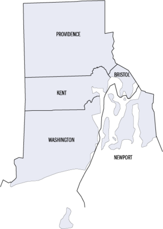
This is a list of properties and districts listed on the National Register of Historic Places in Rhode Island. As of May 29, 2015, there are more than 750 listed sites in Rhode Island. All 5 of the counties in Rhode Island have listings on the National Register.
Ironstone is an historic village,, in the township of Uxbridge, Massachusetts, United States. It derived its name from plentiful bog iron found here which helped Uxbridge to become a center for three iron forges in the town's earliest settlement. South Uxbridge has historic sites, picturesque weddings, hospitality, industrial and distribution centers, and the new Uxbridge High School. This community borders North Smithfield, and Burrillville, Rhode Island, and Millville, Massachusetts. South Uxbridge receives municipal services from Uxbridge, for fire, police, EMS, School district, public works, and other services. There is a South Uxbridge fire station of the Uxbridge fire department. Worcester's Judicial District includes Uxbridge District Court. Ironstone appears on the Blackstone U.S. Geological Survey Map. Worcester County is in the Eastern time zone and observes DST.

Saylesville is a village and historic district in Lincoln, Rhode Island.

The Gardiner Pond Shell Midden is a prehistoric archaeological site in Middletown, Rhode Island, named after George Gardiner who was an early settler in the area. The site includes a large shell midden, in which archaeological finds have been made dating the area's human habitation to the Middle and Late Woodland Period. Finds at the site include agricultural tools such as hoes, planting tools, and stone mortars and pestles. The midden is on the grounds of the Norman Bird Sanctuary.
The Jamestown Archeological District is an expansive archaeological district which is the site of a major prehistoric Native American settlement in Jamestown, Rhode Island. The full extent of archaeologically-sensitive areas has not been fully identified, but is known to extend from Narragansett Avenue in the south to Rhode Island Route 138 in the north, and from Narragansett Bay in the west to North Road. The district overlaps the historically significant Windmill Hill Historic District, and the nearly 300-acre (120 ha) Watson Farm. The district includes one of largest Native American burying grounds in New England, and includes evidence of occupation dating to 3,000 BC.

The Kay Street–Catherine Street–Old Beach Road Historic District is a historic district in Newport, Rhode Island. The area is located north of Newport's well-known Bellevue Avenue, and encompasses an area that was developed residentially between about 1830 and 1890, for the most part before the Gilded Age mansions were built further south. The district is bounded on the south by Memorial Boulevard, on the east by Easton's Pond, on the west by Bellevue Avenue and Kay and Bull Streets, and on the north by Broadway, Rhode Island Avenue, Prairie Avenue, and Champlin Street. The district was added to the National Register of Historic Places on May 22, 1973, with a boundary decrease in 2018.

Arnold Mills Historic District is a historic district encompassing a modest 19th-century mill village in eastern Cumberland, Rhode Island. The district lies along the Nate Whipple Highway and Sneech Pond Road, south of the Arnold Mills Reservoir. Sneech Pond Road was formerly the major east-west highway through the area prior to the construction of the Nate Whipple Highway in the 1960s. The Arnold Mills village is in part bisected by Abbott Run, the stream which serves as the outlet of the reservoir; Sneech Pond Road crosses the run on an early 20th-century steel Pratt pony truss, now closed to vehicular traffic. The houses along this road generally date from the late 18th to mid-19th century, and mainly reflect Federal and Greek Revival styling. The most prominent structure in the district is the Arnold Mills United Methodist Church, located at the western end of the district on Nate Whipple Highway; it was built 1825-27 and remodeled in 1846.

The Furnace Hill Brook Historic and Archeological District in a historic district in Cranston, Rhode Island.
Moswansicut Pond Site, RI-960 is an historic site in Scituate, Rhode Island
The Austin Farm Road Agricultural Area is a rural historic district in Exeter, Rhode Island. The district is bounded on the east by Interstate 95, on the north by the town line, on the south by Austin Farm Road, and on the west by a north-south line through Austin Farm Pond. This agricultural area is relatively little altered since the late 19th century, despite the proximity of the interstate. It includes the farm complex built up by John Austin in the 19th century, which continues to see active use, and the site of an older farm complex, reduced to just the farmhouse, which predates Austin's acquisition of the property. In addition to the farm buildings, it includes a chapel and school house built or maintained by Austin.

Browning's Beach Historic District is a historic district west of the junction between Card Pond and Matunuck Beach Roads in South Kingstown, Rhode Island. It encompasses a cluster of four beach houses located on a barrier beach facing Long Island Sound south of Cards Pond, and accessed via a private gravel drive extending from Cards Pond Road. The four houses, along with several outbuildings, were built in the early years of the 20th century, and are architecturally diverse expressions of Queen Anne, Shingle, and Colonial Revival elements. Typical architectural elements include shingle siding, recessed porches, and chalet-style roofs.

Fort Ninigret is a historic fort and trading post site at Fort Neck Road in Charlestown, Rhode Island, built and occupied by European settlers in the seventeenth century. At its 1883 dedication, Commissioner George Carmichael, Jr. referred to it as "the oldest military post on the Atlantic coast."
The Great Salt Pond Archeological District is a historic district in New Shoreham, Rhode Island. The district was added to the National Register of Historic Places in 1990.

Hillsdale Historic and Archeological District is a historic district in Richmond, Rhode Island. The district was added to the National Register of Historic Places in 1980. It represents the site of the former textile mill village of Hillsdale.

Wyoming is a village and census-designated place on the Wood River in southern Rhode Island, primarily in the town of Richmond, Rhode Island, but extending north across the river into the town of Hopkinton, Rhode Island. The population was 270 at the 2010 census. It is the site of the Wyoming Village Historic District and a post office assigned ZIP code 02898.
The Carbuncle Hill Archaeological District encompasses a collection of archaeological sites in rural western Coventry, Rhode Island. Designated by the state as sites RI-1072 through RI-1079, this discontiguous cluster of sites has the potential to increase knowledge of prehistoric patterns of stone tool procurement, development, and use. The district was added to the National Register of Historic Places in 1985, primarily for its potential to yield further information.
The North End Historic District is a predominantly residential historic district in northwestern Westerly, Rhode Island. The area traces the industrial development of Westerly, with proximity to both its central business district as well as water-based textile mills, and stone quarries further inland. Most of the district's architecture was built between 1832 and 1955. The district is bounded on the east by High Street; on the south by properties on Friendship, West, Pleasant Streets, Marriott Avenue and Industrial Drive; on the west by properties on Pleasant, Canal, Pierce and Pond Streets; and on the north by properties on Pond, Pierce, Pearl, and High Streets, and Turano Avenue.

The Dunns Pond Mound is a historic Native American mound in northeastern Logan County, Ohio, United States. Located near Huntsville, it lies along the southeastern corner of Indian Lake in Washington Township. In 1974, the mound was listed on the National Register of Historic Places as a potential archeological site, with much of its significance deriving from its use as a burial site for as much as nine centuries.
