
The Northern Neck is the northernmost of three peninsulas on the western shore of the Chesapeake Bay in the Commonwealth of Virginia. The Potomac River forms the northern boundary of the peninsula; the Rappahannock River demarcates it on the south. The Northern Neck encompasses the following Virginia counties: Lancaster, Northumberland, Richmond, King George and Westmoreland; it had a total population of 50,158 as of the 2020 census.
Varina Farms, also known as Varina Plantation or Varina Farms Plantation or Varina on the James, is a plantation established in the 17th century on the James River about 10 miles (16 km) south of Richmond, Virginia. An 820-acre (330 ha) property was listed on the National Register of Historic Places in 1977 as "Varina Plantation". At that time it included two contributing buildings and one other contributing site.

Smith's Fort Plantation is a house and parcel of land located in Surry County, Virginia, United States. The current main house on the property, also known as the Faulcon House, dates from 1751. The house has been an example for numerous twentieth century reproductions. It is also known as Warren House and Rolfe-Warren House.

Westmoreland State Park lies within Westmoreland County, Virginia. The park extends about one and a half miles along the Potomac River and covers 1,321 acres. The Horsehead Cliffs provide visitors with a panoramic view of the Potomac River, and lower levels feature fossils and beach access. The park offers hiking, camping, cabins, fishing, boating and swimming, although mechanical issues have kept the swimming pool closed since 2021. Located on the Northern Neck Peninsula, the park is close to historical sites featuring earlier eras: George Washington's birthplace and Stratford Hall, the birthplace of Robert E. Lee.

Faunsdale Plantation is a historic slave plantation near the town of Faunsdale, Alabama, United States. This plantation is in the Black Belt, a section of the state developed for cotton plantations. Until the U.S. Civil War, planters held as many as 186 enslaved African Americans as laborers to raise cotton as a commodity crop.

Menokin, also known as Francis Lightfoot Lee House, was the plantation of Francis Lightfoot Lee near Warsaw, Virginia, built for him by his wife's father, John Tayloe II, of nearby Mount Airy. Lee, a Founding Father, was a signer of the United States Declaration of Independence. Menokin was declared a National Historic Landmark in 1971.

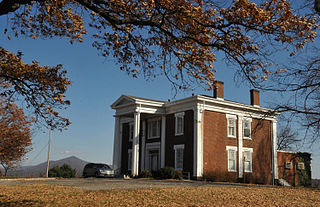
Sabine Hall is a historic house located near Warsaw in Richmond County, Virginia. Built about 1730 by noted planter, burgess and patriot Landon Carter (1710–1778), it is one of Virginia's finest Georgian brick manor houses. Numerous descendants served in the Virginia General Assembly. It was added to the National Register of Historic Places in 1969, and declared a National Historic Landmark in 1970. At the time of its National Register listing, it was still owned by Carter / Wellford descendants.

Staunton River State Park is a state park in Virginia. One of the Commonwealth's original state parks, built by the Civilian Conservation Corps and opening in 1936, it is located along the Staunton River near Scottsburg, Virginia. It is an International Dark Sky Park.

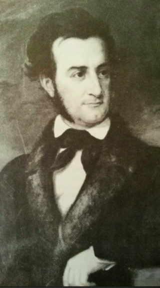
John Tayloe III, of Richmond County, Virginia, was the premier Virginia planter; a politician, businessman, and tidewater gentry scion. He was prominent in elite social circles. A highly successful planter and thoroughbred horse breeder, he was considered the "wealthiest man of his day". A military officer, he also served in the Virginia House of Delegates and Senate of Virginia for nine years. The Tayloe family of Richmond County, including his father, John Tayloe II, and grandfather, John Tayloe I, exemplified gentry entrepreneurship by the diversifying business interests utilizing agriculture to begin vertically integrating including shipbuilding and iron production.

Southwest Mountains Rural Historic District is a national historic district located near Keswick, Albemarle County, Virginia. The district encompasses 854 contributing buildings, 73 contributing sites, 30 contributing structures, and 1 contributing object. It includes a variety of large farms, historic villages, and crossroads communities. The area is known primarily for its large and imposing Federal, Greek Revival, and Georgian Revival plantation houses and country estates. It features a broad range of architecture—mainly domestic and farm-related—from the late 18th, 19th, and 20th centuries.

Edge Hill, also known as Edgehill and Edgehill Farm, is a historic house located near Shadwell in Albemarle County, Virginia, United States.

Ashton Heights Historic District is a national historic district located in Arlington County, Virginia. Today, the Ashton Height Historic District contains 1,097 contributing buildings, one contributing site, and one contributing structure in a residential neighborhood in North Arlington.

Keswick is a historic plantation house near Powhatan, in Chesterfield County and Powhatan County, Virginia, USA. It was built in the early-19th century, and is an "H"-shaped, two-story, gable-roofed, frame-with-weatherboard building. It is supported on brick foundations and has a brick exterior end chimney on each gable. Also on the property are a contributing well house, a smokehouse, the circular "slave quarters," a kitchen, a two-story brick house, a shed, and a laundry.

Long Marsh Run Rural Historic District is a national historic district located just outside Berryville, in Clarke County, Virginia. It encompasses 315 contributing buildings, 16 contributing sites, and 35 contributing structures. The district includes the agricultural landscape and architectural resources of an area distinctively rural that contains numerous large antebellum and postbellum estates, and several smaller 19th-century farms, churches, schools and African-American communities.
Millbank is a historic home and archaeological site and national historic district located near Port Conway, King George County, Virginia. It encompasses 1 contributing building, 8 contributing sites, and 1 contributing structure. Among the archaeological sites are the A. Fitzhugh Plantation Site including the smokehouse and chimney / kitchen sites; the Ballentine Site; the Brick Rubble Site; the Nail Field Site; the Old House Swamp Pointe Site; and a probable Mill Site. The current house is an I-house dwelling built about 1900 on a basement dating to the 18th century. The plantation was initially settled in 1669; the land has been the site of residential occupation and agricultural endeavors since that time.

French's Tavern, also known as Swan's Creek Plantation, Indian Camp, Harris's Store, and The Coleman Place, is a historic house and tavern located near Ballsville, Powhatan County, Virginia. The two-story, frame building complex is in five distinct sections, with the earliest dated to about 1730. The sections consist of the main block, the wing, the annex, the hyphen and galleries. It was built as the manor home for a large plantation, and operated as an ordinary in the first half of the 19th century.

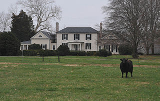
Norwood is a historic plantation house located near Powhatan, Powhatan County, Virginia. It was built in the 18th century and remodeled about 1835. It is a two-story, five bay, Federal style brick dwelling with a hipped roof. The remodeling included the addition of flanking two-story wings and a two-story rear extension. The front facade features a sheltering porch with coupled Ionic order columns, marble paving, and granite steps. Also on the property are the contributing office, plantation kitchen, and privy.
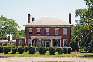
Buena Vista is a historic plantation house located in Roanoke, Virginia. It was built about 1840, and is a two-story, brick Greek Revival style dwelling with a shallow hipped roof and two-story, three-bay wing. The front facade features a massive two-story diastyle Greek Doric order portico. Buena Vista was built for George Plater Tayloe and his wife, Mary (Langhorne) Tayloe. George was the son of John Tayloe III and Anne Ogle Tayloe of the noted plantation Mount Airy in Richmond County and who built The Octagon House in Washington D.C. The property was acquired by the City of Roanoke in 1937, and was used as a city park and recreation center.

The Sebrell Rural Historic District is a national historic district located near Sebrell, Southampton County, Virginia. The district encompasses 112 contributing buildings and 3 contributing site sites near the historically African-American village of Sebrell. The buildings represent a variety of popular architectural styles including Georgian, Greek Revival, Queen Anne, and Italianate. They include residential, agricultural, commercial, governmental, and institutional buildings dating from the 18th to mid-20th centuries. Notable buildings include the Jesse Little Plantation House, W.B. Simmons Farm, Snowden, Quarter Farm, Unity Rowes General Store, Davis and Clark Store, Sebrell United Methodist Church (1910), and the St. Mary's AME Mount Zion Church (1910).
Edward "Thornton" Tayloe was an American Diplomat, planter and scion of colonial tidewater gentry. He was named after his godfather, Edward Thornton a friend and fellow student of his father's at Eton College and His Majesty's ambassador to Washington D.C. He owned estates in King George County, Virginia and the Canebrake. He was the private secretary to Joel Roberts Poinsett during his time as the first minister to Mexico. He married his first cousin, Mary Ogle, at Belair Mansion Prince George's Co., Maryland during Christmas in 1830.


