
The walleye, also called the yellow pike or yellow pikeperch or yellow pickerel, is a freshwater perciform fish native to most of Canada and to the Northern United States. It is a North American close relative of the European zander, also known as the pikeperch. The walleye is sometimes called the yellow walleye to distinguish it from the blue walleye, which is a color morph that was once found in the southern Ontario and Quebec regions, but is now presumed extinct. However, recent genetic analysis of a preserved (frozen) 'blue walleye' sample suggests that the blue and yellow walleye were simply phenotypes within the same species and do not merit separate taxonomic classification.

Prairies are ecosystems considered part of the temperate grasslands, savannas, and shrublands biome by ecologists, based on similar temperate climates, moderate rainfall, and a composition of grasses, herbs, and shrubs, rather than trees, as the dominant vegetation type. Temperate grassland regions include the Pampas of Argentina, Brazil and Uruguay, and the steppe of Ukraine, Russia and Kazakhstan. Lands typically referred to as "prairie" tend to be in North America. The term encompasses the area referred to as the Interior Lowlands of Canada, the United States, and Mexico, which includes all of the Great Plains as well as the wetter, hillier land to the east.

A marsh is — according to ecological definitions — a wetland that is dominated by herbaceous rather than woody plant species. More in general, the word can be used for any low-lying and seasonally waterlogged terrain. In Europe and in agricultural literature low-lying meadows that require draining and embanked polderlands are also referred to as marshes or marshland.

An endorheic basin is a drainage basin that normally retains water and allows no outflow to other, external bodies of water ; instead, the water drainage flows into permanent and seasonal lakes and swamps that equilibrate through evaporation. Endorheic basins also are called closed basins, terminal basins, and internal drainage systems.

Lake Mendota is a freshwater eutrophic lake that is the northernmost and largest of the four lakes in Madison, Wisconsin. The lake borders Madison on the north, east, and south, Middleton on the west, Shorewood Hills on the southwest, Maple Bluff on the northeast, and Westport on the northwest. Lake Mendota acquired its present name in 1849 following a proposal by a surveyor named Frank Hudson, who claimed to be familiar with local Native American languages; Lyman C. Draper, the first corresponding secretary of the Wisconsin Historical Society, proposed that 'Mendota' could have been a Chippewa word meaning 'large' or 'great.'
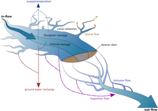
Ecohydrology is an interdisciplinary scientific field studying the interactions between water and ecological systems. It is considered a sub discipline of hydrology, with an ecological focus. These interactions may take place within water bodies, such as rivers and lakes, or on land, in forests, deserts, and other terrestrial ecosystems. Areas of research in ecohydrology include transpiration and plant water use, adaption of organisms to their water environment, influence of vegetation and benthic plants on stream flow and function, and feedbacks between ecological processes, the soil carbon sponge and the hydrological cycle.
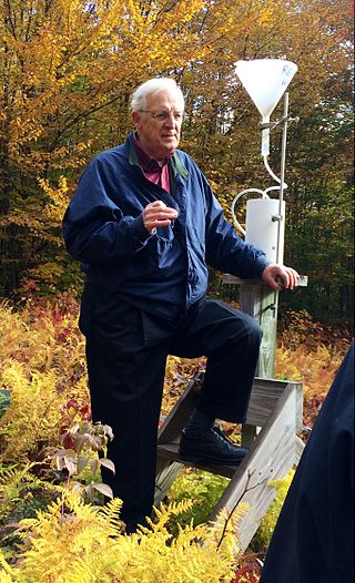
Gene Elden Likens is an American limnologist and ecologist. He co-founded the Hubbard Brook Ecosystem Study at the Hubbard Brook Experimental Forest in 1963, and founded the Cary Institute of Ecosystem Studies in Millbrook, New York in 1983.

Prairie restoration is a conservation effort to restore prairie lands that were destroyed due to industrial, agricultural, commercial, or residential development. The primary aim is to return areas and ecosystems to their previous state before their depletion.
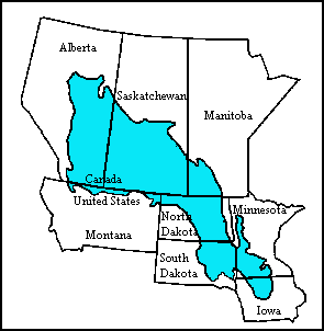
The Prairie Pothole Region is an expansive area of the northern Great Plains that contains thousands of shallow wetlands known as potholes. These potholes are the result of glacier activity in the Wisconsin glaciation, which ended about 10,000 years ago. The decaying ice sheet left behind depressions formed by the uneven deposition of till in ground moraines. These depressions are called potholes, glacial potholes, kettles, or kettle lakes. They fill with water in the spring, creating wetlands, which range in duration from temporary to semi-permanent. The region covers an area of about 800,000 sq. km and expands across three Canadian provinces and five U.S. states. The hydrology of the wetlands is variable, which results in long term productivity and biodiversity. The PPR is a prime spot during breeding and nesting season for millions of migrating waterfowl.

The geology of Minnesota comprises the rock, minerals, and soils of the U.S. state of Minnesota, including their formation, development, distribution, and condition.

National Ecological Observatory Network (NEON) is a large facility program operated by Battelle Memorial Institute and funded by the National Science Foundation. In full operation since 2019, NEON gathers and provides long-term, standardized data on ecological responses of the biosphere to changes in land use and climate, and on feedback with the geosphere, hydrosphere, and atmosphere. NEON is a continental-scale research platform for understanding how and why our ecosystems are changing.

The Traverse Gap is an ancient river channel occupied by Lake Traverse, Big Stone Lake and the valley connecting them at Browns Valley, Minnesota. It is located on the border of the U.S. states of Minnesota and South Dakota. Traverse Gap has an unusual distinction for a valley: it is crossed by a continental divide, and in some floods, water has flowed across that divide from one drainage basin to the other. Before the Anglo-American Convention of 1818 it marked the border between British territory in the north and U.S. – or earlier, French – territory in the south.

The Long Prairie River is a tributary of the Crow Wing River, 96 miles (154 km) long, in central Minnesota in the United States. Via the Crow Wing River, it is part of the watershed of the Mississippi River, draining an area of 892 square miles (2,310 km2) in a generally rural region.

Buffalo Pound Lake is a eutrophic prairie lake in Saskatchewan, Canada, formed from glaciation about 10,000 years ago, on the Qu'Appelle River approximately 28 kilometres (17 mi) north of Moose Jaw and 11 kilometres (6.8 mi) north-east of Tuxford. The lake gets its name from the method used by First Nations people to capture the bison using the natural topography as corrals or buffalo pounds. Bison, once numbering more than 60 million on the prairies but almost extinct by 1900, were reintroduced into the area in 1972.

Trout Lake is in Vilas County, Wisconsin, near the towns of Boulder Junction and Arbor Vitae, Wisconsin. With a surface area of 6.208 sq mi (16.079 km2) and a volume of 0.058 cu mi (0.240 km3), Trout Lake is one of the largest lakes in Vilas County. It has 16.1 mi (25.9 km) of shoreline, a large portion of which is undeveloped. There are also seven islands within the lake: Miller Island, Zimmerman Island, Haunted Island, Easter Island, Fisk Island, Chocolate Drop Island, and an unnamed island. It is a dimictic oligotrophic lake that supports a large number of sport fish, which has made it a popular angling destination.
The ecology of the Great Plains is diverse, largely owing to their great size. Differences in rainfall, elevation, and latitude create a variety of habitats including short grass, mixed grass, and tall-grass prairies, and riparian ecosystems.

The Fonteyn Kill is a 1.5-kilometer-long (0.93 mi) urban stream flowing through Dutchess County, New York, onto the campus of Vassar College, and into the Casperkill. The stream was first on land inhabited by the native Wappinger band before being transferred to the Dutch and then the British. A mill was built along the kill by 1714 and the stream's presence influenced Matthew Vassar's decision to locate his college in the area. The artificial Vassar Lake lies midway down the Fonteyn Kill and was once used for ice skating and boating.
Toolik Lake is an Arctic lake located within the North Slope Borough, Alaska. It is in a remote wilderness area managed by the Bureau of Land Management accessed by the Dalton Highway. It is 130 mi (210 km) south of Prudhoe Bay in the northern foothills of the Brooks Range. The name is derived from the Iñupiat word tutlik, meaning yellow-billed loon.

Holly René Barnard is an American geographer and Associate Professor of Geography at the University of Colorado Boulder. She studies how vegetation impacts the dynamics and pathways of streams. In 2020 Barnard was awarded a $7 million National Science Foundation grant to set up a Critical Zone Observatory at the University of Colorado Boulder.
Kathleen C. Weathers is an ecosystem scientist and the G. Evelyn Hutchinson Chair in Ecology at the Cary Institute of Ecosystem Studies. Her expertise focuses on understanding the ecology of air-land-water interactions. Weathers is the current elected President of the Ecological Society of America (2020-2021).


