Prehistory of the Canadian Maritimes

Last updated

Humans have been present in the Canadian Maritime provinces for 10,600 years. In spite of being the first part of Canada to be settled by Europeans, research into the prehistory of the Maritimes did not become extensive until 1969. By the early 1980s, several full-time archaeologists focused on the region. [1]

Contents

Paleo-Indian Period (9000 BCE-7000 BCE)

Initially, archaeologists thought that glaciers had not melted away fast enough in the Maritimes for Paleo-Indians to be present. However, discoveries at Camp Debert (now known as CFS Debert, site of Canada's retired Maritimes "Diefenbunker") a military base in Colchester County, Nova Scotia after World War II changed that thinking. Researchers from the Peabody Foundation for Archaeology in Andover, Massachusetts, discovered stone flakes and projectile points exposed by bulldozing and wind erosion. While Camp Debert was the major find, archaeologists subsequently found fluted pointed at Kingsclear and Quaco Head in New Brunswick, at Souris, Prince Edward Island and Cape Blomidon on the Bay of Fundy in Nova Scotia. Although the Paleo-Indians at Camp Debert likely lived in a tundra environment, wood was plentiful enough to leave large amounts of charcoal at the site.

George MacDonald, director of the Debert Archaeological Project in 1968 interpreted hearths and shallow pits as simple wooden structures, used as part of a winter encampment, and likely covered in hides. While mastodons may have been present, inhabitants of the Debert site likely hunted caribou with fluted spears and darts. Large stones were used to break bones to extract marrow, while biface tools would have found use cutting meat. Caribou herds in central Nova Scotia may have migrated inland for the winter from Cobequid Bay, to higher altitudes where high winds reduced snow cover. Archaeologists debate whether Debert site Paleo-Indians stored food through the winter and the extent of shell fishing, seal and bird hunting. [2] Paleo-Indian presence is limited in the archaeological record for several thousand years, although archaeologist David Keenlyside found triangular spear tips in Prince Edward Island dated to the period. [3]

Late Pre-Ceramic Period (3000 BCE-500 BCE)

Because there was never extensive farming in the Maritimes to divide the Archaic from other periods of human prehistory, archaeologists use the Late Pre-Ceramic period as a regional period to subdivide the Archaic period.

Laurentian culture

The Laurentian culture, identified from the St. Lawrence River valley, New York, Ontario and Vermont also extended into inland New Brunswick, the area near Chaleur Bay and possibly parts of coastal Nova Scotia. Ulu stone knives, polished stone gouges and axes, as well as slate spear points are all defining artifacts of the culture. Laurentian peoples seem to have adapted to a coniferous forest and hunted white-tailed deer and moose, supplemented by rabbit, beaver, fox, martin, pike and sucker fish. However, Laurentian peoples are still poorly understood in the Maritimes. [4]

Maritime Archaic culture

Sea level rise as a result of isostatic uplift has hidden much of the evidence of Maritime Archaic peoples who may have spanned and traded from Maine to Newfoundland and occupied much of coastal Nova Scotia. The Turner Farm site in Maine offers artifact dates of 2500 BCE to 2400 BCE and similar artifacts were found in Rafter Lake outside of Halifax. The Maritime Archaic diet is understood from sites on Monhegan Island in Maine, where the remains of swordfish, harbor seals, gray seals, sturgeon, codfish, sea mink and sea birds were discovered. By 2500 BCE, Maritime Archaic peoples had developed barbed harpoons to catch sea mammals and large numbers of harpoons remained at the site. Although no evidence of houses or tents remain, Maritime Archaic totems and religious amulets have been found, sourced from the sea. By 3500 years ago, Maritime Archaic people and technology such as slate spears disappeared from the region. [5]

Shield culture

Mostly found in the boreal forests of the Canadian Shield, Shield peoples may have inhabited two sites in the Maritimes. Dead Man's Pool—a salmon pool on the Tobique River in New Brunswick—preserved large spear points for catching fish and thin, flake scrapers for processing fish. In addition to catching fish, the Shield peoples at Dead Man's Pool likely processed hides and killed larger animals such as caribou. Field plowing at Cape North on Cape Breton revealed the McEvoy site, which preserved a few scrapers, knives and biface blades. Archaeologists have debated whether or not the two sites are actually remnants of the Shield culture. [6]

Susquehanna culture

The Susquehanna peoples used slate and argillite tools, similar to those used on the Piedmont plateau further south in the eastern US and left artifacts along the Bay of Fundy coast in New Brunswick. Unlike other Maritime groups they cremated the dead and buried bones and ashes away from the cremation pit. Archaeologists have debated whether the Susquehanna peoples ultimately became Mi'kmaq or Maliseet, or whether they faded out of the region. [7]

Ceramic Period (500 BCE-1500 CE)

Maliseet & Passamaquoddy Territory Wohngebiet Maliseet.png
Maliseet & Passamaquoddy Territory

In the Ceramic Period, a regional archaeological term, modern native cultures of the Maritimes began to take shape. Maliseet people were predominant in southwest Nova Scotia and southern New Brunswick, spanning both shores of the Bay of Fundy, while Mi'kmaq lived throughout the rest of New Brunswick, Prince Edward Island and Nova Scotia. New stone tools designed to be mounted to a shaft appeared in southern New Brunswick several hundred years before the introduction of pottery. Pre-Ceramic technology faded out of the area, with some of the last remains at Teacher's Cove and St. Croix Island, proposed as staging grounds for marine mammal hunts by researcher David Sanger. When ceramics appeared, they had round bottoms and were marked with cords. The heaviness of clay cooking pots may have limited mobility and some groups seem to have abandoned clay vessels in exchange for birch bark containers. At the time of European contact, many people quickly gave up on clay pots and switched to copper kettles. Pots were tempered with crushed granite, which left behind glittering quartz and mica.

Maliseet lifestyles are inferred from European historical records. Groups spent winter inland hunting deer, moose and beaver and relocated to the rivers and the ocean during the spring, summer and fall. However, archaeological evidence suggests that this was a change in the seasonal pattern shortly before European explorers arrived. David Sanger launched a survey of inland ponds, but did not find signs of seasonal encampments. He suggested that settlements might instead have concentrated on the ocean, with warm weather fishing for smelt, herring, gaspereau and salmon. Sanger discovered oval pit houses in Bocabec on the New Brunswick coast, with tunnel-like entrance, a sunken hearth and layers of gravel laid down internally probably for sanitation.

Middens preserve thousands of soft clam shells, oldsquaw ducks, common murre and great auk bones along the New Brunswick coast. Flat bone needles were used to weave mats and snowshoe webbing. Shell middens on Prince Edward Island, excavated by the David Keenlyside and Judy Buxton Keenlyside in the 1970s indicate small summer Mi'kmaq encampments. The Oxbow site, on a tributary of the Miramichi River displays polished stone-axes, snub-nosed scrapers and arrow points for hafting. Mi'kmaq sites have some technological differences, such as bark peelers, knives made out of beaver teeth and different awls and needles. [8]

Clay pipes traded from tribes in Ohio were found in Dartmouth, Nova Scotia in the 1930s. In 1972, Joseph Augustine, a resident of the Red Bank First Nations Reserve in New Brunswick directed archaeologists to a burial mound that contained four skeletons, more than a thousand copper beads, a slate gorget and preserved fabric. The rectangular slate gorget contained two drilled holes, similar to the Adena burial cult in the Ohio River valley. [9]

Related Research Articles

<span class="mw-page-title-main">The Maritimes</span> Region of Atlantic Canada

The Maritimes, also called the Maritime provinces, is a region of Eastern Canada consisting of three provinces: New Brunswick, Nova Scotia, and Prince Edward Island. The Maritimes had a population of 1,899,324 in 2021, which makes up 5.1% of Canada's population. Together with Canada's easternmost province, Newfoundland and Labrador, the Maritime provinces make up the region of Atlantic Canada.

<span class="mw-page-title-main">Bay of Fundy</span> Bay on the east coast of North America

The Bay of Fundy is a bay between the Canadian provinces of New Brunswick and Nova Scotia, with a small portion touching the U.S. state of Maine. It is an arm of the Gulf of Maine. Its tidal range is the highest in the world. The name is probably a corruption of the French word fendu, meaning 'split'.

<span class="mw-page-title-main">Kings County, Nova Scotia</span> County in Nova Scotia, Canada

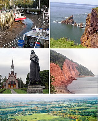
Kings County is a county in the Canadian province of Nova Scotia. With a population of 62,914 in the 2021 Census, Kings County is the third most populous county in the province. It is located in central Nova Scotia on the shore of the Bay of Fundy, with its northeastern part forming the western shore of the Minas Basin.

<span class="mw-page-title-main">Mi'kmaq</span> Indigenous ethnic group of eastern North America

The Mi'kmaq are a First Nations people of the Northeastern Woodlands, indigenous to the areas of Canada's Atlantic Provinces, primarily Nova Scotia, New Brunswick, and Newfoundland, and the Gaspé Peninsula of Quebec as well as Native Americans in the northeastern region of Maine. The traditional national territory of the Mi'kmaq is named Miꞌkmaꞌki.

<span class="mw-page-title-main">Plano cultures</span> Archaeological cultures of North America

The Plano cultures is a name given by archaeologists to a group of disparate hunter-gatherer communities that occupied the Great Plains area of North America during the Paleo-Indian or Archaic period.

The Maritime Archaic is a North American cultural complex of the Late Archaic along the coast of Newfoundland, the Canadian Maritimes and northern New England. The Maritime Archaic began in approximately 7000 BC and lasted until approximately 3500 BC, corresponding with the arrival of the Paleo-Eskimo groups who may have outcompeted the Maritime Archaic for resources. The culture consisted of sea-mammal hunters in the subarctic who used wooden boats. Maritime Archaic sites have been found as far south as Maine and as far north as Labrador. Their settlements included longhouses, and boat-topped temporary or seasonal houses. They engaged in long-distance trade, as shown by white chert from northern Labrador being found as far south as Maine.

Metepenagiag, also known as Red Bank is a Mi'kmaq First Nation band government in New Brunswick, Canada on the other side of the Miramichi river from Sunny Corner.

<span class="mw-page-title-main">History of New Brunswick</span>

The history of New Brunswick covers the period from the arrival of the Paleo-Indians thousands of years ago to the present day. Prior to European colonization, the lands encompassing present-day New Brunswick were inhabited for millennia by the several First Nations groups, most notably the Maliseet, Mi'kmaq, and the Passamaquoddy.

<span class="mw-page-title-main">Gaspereau Lake</span>

Gaspereau Lake is a lake in Kings County, Nova Scotia, Canada, about 10 km south of the town of Kentville, Nova Scotia on the South Mountain. It is the largest lake in Kings County, and the fifth largest lake in Nova Scotia. The lake is shallow with dozens of forested islands and hundreds of rocky islets (skerries).

<span class="mw-page-title-main">Isle Haute</span>

Isle Haute is an island in the upper regions of Bay of Fundy in Nova Scotia, near the entrance to the Minas Basin. It is 16 kilometers from Harbourville and eight kilometers south-southwest of Cape Chignecto. The island is part of Cumberland County, Nova Scotia and is three kilometres (1.9 mi) long and 400 metres (1,300 ft) wide. The Mi'kmaq used the island to make stone tools before Europeans arrived and called the island "Maskusetik", meaning place of wild beans, hidden oats. In 1604, Samuel de Champlain gave the present name to the island, which means "High Island" in French, when he observed the towering bluffs, timber and fresh-water springs. The steep 100 m (328 ft) basalt cliffs of the island are the result from volcanic eruptions in the Jurassic period and may have been connected to the North Mountain volcanic ridge on the mainland 200 million years ago, before the Bay of Fundy was formed.

The Debert Palaeo-Indian Site is located nearly three miles southeast of Debert, Colchester County, Nova Scotia, Canada. The Nova Scotia Museum has listed the site as a Special Place under the Special Places Protection Act. The site acquired its special status when it was discovered as the only and oldest archaeological site in Nova Scotia. The Debert site is significant to North American archaeology because it is the most North-easterly Palaeo-Indian site discovered to date. It also provides evidence for the earliest human settlements in eastern North America, which have been dated to 10,500–11,000 years ago. Additionally, this archaeological site remains one of the few Palaeo-Indian settlements to be identified within the region of North America that was once glaciated.

<span class="mw-page-title-main">Cape d'Or</span> Lighthouse

Cape d'Or is a headland located near Advocate, Cumberland County, on the Bay of Fundy coast of the Canadian province of Nova Scotia.

<span class="mw-page-title-main">Military history of the Mi'kmaq</span> Militias of Mikmaq

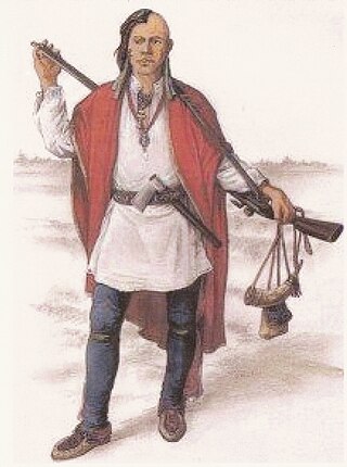
The military history of the Mi'kmaq consisted primarily of Mi'kmaq warriors (smáknisk) who participated in wars against the English independently as well as in coordination with the Acadian militia and French royal forces. The Mi'kmaq militias remained an effective force for over 75 years before the Halifax Treaties were signed (1760–1761). In the nineteenth century, the Mi'kmaq "boasted" that, in their contest with the British, the Mi'kmaq "killed more men than they lost". In 1753, Charles Morris stated that the Mi'kmaq have the advantage of "no settlement or place of abode, but wandering from place to place in unknown and, therefore, inaccessible woods, is so great that it has hitherto rendered all attempts to surprise them ineffectual". Leadership on both sides of the conflict employed standard colonial warfare, which included scalping non-combatants. After some engagements against the British during the American Revolutionary War, the militias were dormant throughout the nineteenth century, while the Mi'kmaq people used diplomatic efforts to have the local authorities honour the treaties. After confederation, Mi'kmaq warriors eventually joined Canada's war efforts in World War I and World War II. The most well-known colonial leaders of these militias were Chief (Sakamaw) Jean-Baptiste Cope and Chief Étienne Bâtard.

<span class="mw-page-title-main">Military history of the Maliseet</span>

The Maliseet militia was made up of warriors from the Maliseet of northeastern North America. Along with the Wabanaki Confederacy, the French and Acadian militia, the Maliseet fought the British through six wars over a period of 75 years. They also mobilized against the British in the American Revolution. After confederation, Maliseet warriors eventually joined Canada's war efforts in World War I and World War II.

<span class="mw-page-title-main">Peace and Friendship Treaties</span> Peace treaties between various bands of the Miꞌkmaq and the English in Halifax, Nova Scotia

The Peace and Friendship Treaties were a series of written documents that the Crown of the Royal House of Stuart signed bearing the Authority of Great Britain between 1725 and 1779 under the English Crown and Throne of the Royal House of Stuart with various Mi’kmaq, Wolastoqiyik (Maliseet), Abenaki, Penobscot, and Passamaquoddy peoples living in parts of what are now the Maritimes and Gaspé region in Canada and the northeastern United States. Primarily negotiated to reaffirm the peace after periods of war and to facilitate trade, these treaties remain in effect to this day.

At the end of the last Ice Age, Newfoundland and Labrador were covered in thick ice sheets. The province has had a continuous human presence for approximately 5000 years. Although Paleo-Indians are known from Nova Scotia dating back 11,000 years, no sites have been found north of the St. Lawrence. The oldest traces of human activity, in the form of quartz and quartzite knives, were discovered in 1974 in southern Labrador, but some archaeologists have speculated that a human presence may go back as much as 9000 years. Highly acidic soils have destroyed much of the bone and other organic material left behind by early humans and thus complicates archaeological research.

Humans have inhabited Quebec for 11,000 years beginning with the de-glaciated areas of the St. Lawrence River valley and expanding into parts of the Canadian Shield after glaciers retreated 5,000 years ago. Quebec has almost universally acidic soils that destroy bone and many other traces of human activity, complicating archaeological research together with development in parts of southern Quebec. Archaeological research only began in earnest in the 1960s and large parts of the province remain poorly researched.

<span class="mw-page-title-main">Maritime Peninsula</span>

The Maritime Peninsula is a region of eastern North America that extends from the Kennebec River in the U.S. state of Maine northeast to the Maritime provinces of Canada and Quebec's Gaspé Peninsula. It is bounded by the Gulf of Saint Lawrence to the north and the Gulf of Maine to the south.

The prehistory of New England is an important topic of research for New England archaeologists. Humans reached the current-day New England region by at least 10,500 years ago and likely earlier, occupying a recently de-glaciated environment. Pre-contact Native American groups in New England did not have full-fledged market economies and physical artifacts tended to change very slowly. However, technological shifts brought agriculture and ceramics to the region prior to the arrival of European settlers in the 17th century.

References

  1. Tuck 1984, p. 1.
  2. Wright 1979, p. 7-13.
  3. Tuck 1984, p. 16.
  4. Tuck 1984, p. 20-26.
  5. Tuck 1984, p. 27-30.
  6. Tuck 1984, p. 31-33.
  7. Tuck 1984, p. 35-36.
  8. Tuck 1984, p. 79-81.
  9. Tuck 1984, p. 86-91.

Bibliography

Further reading