Prestwick Burgh Hall

Last updated

Prestwick Burgh Hall
Prestwick Town Hall.jpg
Prestwick Burgh Hall in 2004 before the steeple was dismantled
LocationKirk Street, Prestwick
Coordinates 55°30′08″N4°36′38″W / 55.5021°N 4.6105°W / 55.5021; -4.6105 Coordinates: 55°30′08″N4°36′38″W / 55.5021°N 4.6105°W / 55.5021; -4.6105
Built1837
Architectural style(s) Gothic Revival style
Listed Building – Category B
Official nameOld Burgh Chambers (now County Council District Office)
Designated14 April 1971
Reference no.LB40329
South Ayrshire UK location map.svg
Red pog.svg
Shown in South Ayrshire

Prestwick Burgh Hall, also known as Prestwick Freeman's Hall and Prestwick Freemen's Hall, is a municipal building in Kirk Street, Prestwick, Scotland. The structure, which served as the meeting place of Prestwick Burgh Council, is a Category B listed building. [1]

Contents

History

The first municipal building in Prestwick was an early 18th century tolbooth. [2] The tolbooth was used as the offices and meeting place of the chancellor and the two bailies who administered the town: they were elected annually by the 36 freemen of the burgh who owned 1,000 acres (400 ha) of land in and around the town. [3] The current building was commissioned by the freemen of Prestwick for use as the local burgh school. [4] [5] [6] It was designed in the Gothic Revival style, built in ashlar stone and was completed in 1837. [7]

The design involved a symmetrical main frontage with three bays facing onto the corner of The Cross and Kirk Street; the central bay, which projected forward, featured a porch with an arched doorway and an octagonal tower above. The tower was fenestrated with a lancet window on the first floor and featured a clock face in the stage above which was surmounted by a spire. There were lancet windows in the outer bays. The ground floor was initially used as a prison and the first floor was used by the burgh school which accommodated some 60 children. [4]

By the late 19th century the burgh council had assumed most of the functions of the freemen and the building had become the burgh hall. [8] It continued in that use until the burgh council established the municipal buildings in Links Road in the late 1930s. [9] [10] The former burgh hall was then acquired by Ayrshire County Council and became their local district offices. [1] [11]

After the steeple was found to be structurally unsound, it was removed in 2011: [12] a firm of consultants advised that it should be rebuilt using new masonry and that the original stone should be used as template. [13] Although residents lobbied for it to be restored South Ayrshire Council failed to attract support from the Heritage Lottery Fund, or any other charitable source, to carry out the necessary works. [14]

See also

Related Research Articles

<span class="mw-page-title-main">Ayrshire</span> Historic county in Scotland

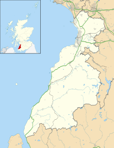
Ayrshire is a historic county and registration county in south-west Scotland, located on the shores of the Firth of Clyde. Its principal towns include Ayr, Kilmarnock and Irvine and it borders the counties of Renfrewshire and Lanarkshire to the north-east, Dumfriesshire to the south-east, and Kirkcudbrightshire and Wigtownshire to the south. Like many other counties of Scotland it currently has no administrative function, instead being sub-divided into the council areas of East Ayrshire, North Ayrshire and South Ayrshire. It has a population of approximately 366,800.

<span class="mw-page-title-main">Ayr</span> Administrative centre and town in Scotland

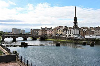
Ayr is a town situated on the southwest coast of Scotland. It is the administrative centre of the South Ayrshire council area and the historic county town of Ayrshire. With a population of 46,982 Ayr is the 16th largest settlement in Scotland and second largest town in Ayrshire by population. The town is contiguous with the smaller town of Prestwick to the north.

<span class="mw-page-title-main">Prestwick</span> Town and former royal burgh in Scotland

Prestwick is a town in South Ayrshire on the west coast of Ayrshire in Scotland about 30 miles southwest of Glasgow. It adjoins the larger town of Ayr to the south on the Firth of Clyde coast, the centre of which is about two miles south, and the small village of Monkton to the north. It had a population of 14,901 at the 2011 census.

<span class="mw-page-title-main">Girvan Steeple</span> Municipal building in Girvan, Scotland

The Girvan Steeple is a steeple and the site of a former townhouse in Girvan, South Ayrshire, Scotland. Its popular name, "Stumpy Tower", "Stumpy Jail" or "Auld Stumpy", is derived from the Gaelic Olladh Stiom Paidh, meaning "Great Circle of Justice". It is a Category B listed building.

<span class="mw-page-title-main">Tolbooth</span>

A tolbooth or town house was the main municipal building of a Scottish burgh, from medieval times until the 19th century. The tolbooth usually provided a council meeting chamber, a court house and a jail. The tolbooth was one of three essential features in a Scottish burgh, along with the mercat cross and the kirk (church).

<span class="mw-page-title-main">Dumbarton Burgh Hall</span> Municipal Building in Dumbarton, Scotland

Dumbarton Burgh Hall is a municipal structure in Church Street, Dumbarton, West Dunbartonshire, Scotland. The building, which is the headquarters of West Dunbartonshire Council, is Category A listed.

<span class="mw-page-title-main">Ayr Town Hall</span> Municipal Building in Ayr, Scotland

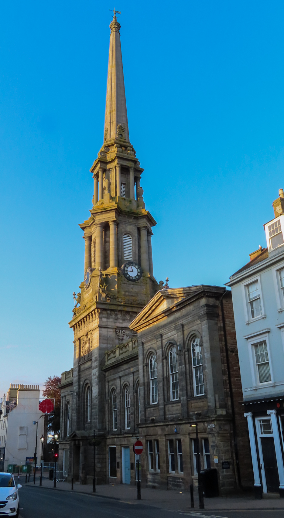
Ayr Town Hall is a municipal building in New Bridge Street, Ayr, Scotland. The town hall, which was the headquarters of Ayr Burgh Council, is a Category A listed building.

<span class="mw-page-title-main">Musselburgh Tolbooth</span> Municipal building in Musselburgh, Scotland

Musselburgh Tolbooth is a municipal building in the High Street in Musselburgh, East Lothian, Scotland. The tolbooth, which was the headquarters of Musselburgh Burgh Council, is a Category A listed building. At right angles and attached to it is the Musselburgh Town House.

<span class="mw-page-title-main">Wigtown County Buildings</span> Municipal building in Wigtown, Scotland

Wigtown County Buildings, also known as Wigtown County Buildings and Town Hall, is a municipal building in The Square, Wigtown, Scotland. The structure primarily served as the meeting place and town hall for Wigtown Burgh Council, but was also used for some meetings of Wigtownshire County Council. It is a Category B listed building.

<span class="mw-page-title-main">Troon Town Hall</span> Municipal building in Troon, Scotland

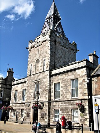
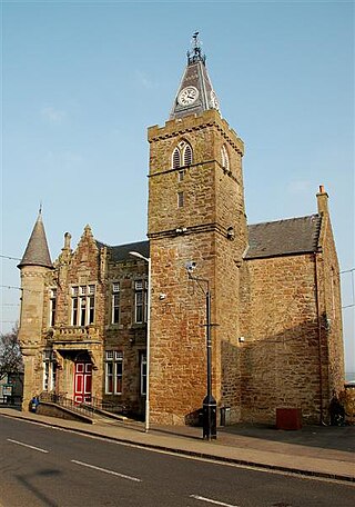
Troon Town Hall is a municipal building in Ayr Street, Troon, Scotland. The structure, which serves as the meeting place of Troon Community Council, is a Category B listed building.

<span class="mw-page-title-main">Kirkcudbright Town Hall</span> Municipal building in Kirkcudbright, Scotland

Kirkcudbright Town Hall is a municipal building in St Mary's Street, Kirkcudbright, Scotland. The building, which was the headquarters of Kirkcudbright Burgh Council, is a Category B listed building.

<span class="mw-page-title-main">Nairn Town and County Buildings</span> Municipal building in Nairn, Scotland

Nairn Town and County Buildings is a municipal structure in the High Street, Nairn, Highland, Scotland. The structure, which is used as a service point for The Highland Council, is a Category B listed building.

<span class="mw-page-title-main">Glasgow Tolbooth</span> Municipal Building in Scotland

The Glasgow Tolbooth was a municipal structure at Glasgow Cross, Glasgow, Scotland. The main block, which was the meeting place of the Royal Burgh of Glasgow, was demolished in 1921 leaving only the steeple standing. The steeple is a Category A listed building.

<span class="mw-page-title-main">Maybole Town Hall</span> Municipal building in Maybole, Scotland

Maybole Town Hall is a municipal structure in the High Street in Maybole, South Ayrshire, Scotland. The structure, which is used as a community events venue, is a Category B listed building.

<span class="mw-page-title-main">Darvel Town Hall</span> Municipal building in Darvel, Scotland

Darvel Town Hall is a municipal building in West Main Street, Darvel, East Ayrshire, Scotland. The structure, which is used as a library and a community events venue, is a Category B listed building.

<span class="mw-page-title-main">Pittenweem Parish Church and Tolbooth Steeple</span> Municipal building in Pittenweem, Scotland

Pittenweem Parish Church and Tolbooth Steeple is an ecclesiastical and municipal complex in the High Street, Pittenweem, Fife, Scotland. The structure, which is used as the local parish church, is a Category A listed building.

<span class="mw-page-title-main">West Wemyss Tolbooth</span> Municipal building in West Wemyss, Scotland

West Wemyss Tolbooth is a municipal building in Main Street, West Wemyss, Fife, Scotland. The structure, which is used as commercial offices, is a Category B listed building.

<span class="mw-page-title-main">Newburgh Town House</span> Municipal building in Newburgh, Scotland

Newburgh Town House is a municipal building in the High Street in Newburgh, Fife, Scotland. The structure, which is used as a series of artists' studios, is a Category B listed building.

<span class="mw-page-title-main">Strathmiglo Town House</span> Municipal building in Strathmiglo, Scotland

Strathmiglo Town House is a municipal structure in the High Street, Strathmiglo, Fife, Scotland. The structure, which is now disused, is a Category A listed building.

<span class="mw-page-title-main">Beith Townhouse</span> Municipal building in Beith, Scotland

Beith Townhouse is a municipal building in The Strand, Beith, North Ayrshire, Scotland. The structure, which is currently used as an information and heritage centre, is a Category B listed building.

References

  1. 1 2 Historic Environment Scotland. "Old Burgh Chambers (now County Council District Office) (LB40329)" . Retrieved 14 August 2021.
  2. Tolbooths and town-houses: civic architecture in Scotland to 1833. Royal Commission on the Ancient and Historical Monuments of Scotland. 1996. ISBN   978-0114957995.
  3. Escott, T. H. S. (1885). The Fourtnightly. Vol. 38. Chapman and Hall.
  4. 1 2 Historic Environment Scotland. "Prestwick, Kirk Street, Council Offices (205038)". Canmore . Retrieved 14 August 2021.
  5. "Ordnance Survey Map 1858 showing the "burgh school"" . Retrieved 14 August 2021.
  6. "Prestwick History". Visit Prestwick. Retrieved 14 August 2021.
  7. Groome, Francis H. (1885). "Prestwick". Ordnance Gazetteer of Scotland: A Survey of Scottish Topography, Statistical, Biographical and Historical. Retrieved 14 August 2021.
  8. "Ordnance Survey Map 1896 showing the "burgh hall"" . Retrieved 14 August 2021.
  9. "Legal Services review of 15 Links Road, Prestwick property". South Ayrshire Council. 19 July 2015. Retrieved 14 August 2021.
  10. "No. 16912". The Edinburgh Gazette . 30 November 1951. p. 601.
  11. "Ordnance Survey Map 1896 showing the "district offices"" . Retrieved 14 August 2021.
  12. "Give us our steeple back!". Ayr Advertiser. 30 May 2011. Retrieved 14 August 2021.
  13. "Conservation" (PDF). Mast Architects. Retrieved 14 August 2021.
  14. "Residents want to bring back Prestwick's steeple". Ayr Advertiser. 18 October 2017. Retrieved 14 August 2021.