Related Research Articles

The Piccadilly line is a London Underground line that runs between Cockfosters in suburban north London and Acton Town in the west, where it divides into two branches: one of these runs to Heathrow Airport and the other to Uxbridge in northwest London, with some services terminating at Rayners Lane.
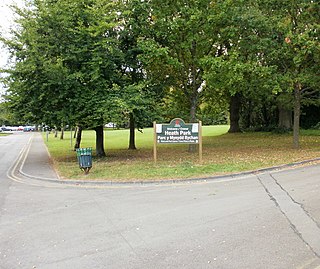
Heath is a district, community and coterminous electoral ward in the north of Cardiff, capital of Wales. It is a predominately affluent area with property prices being the third highest in the city. The area is known for its traditional 1930's detached and semi-detached properties with large south facing gardens. All roads are tree lined roads and the notable attraction of Heath Park and the joining of the University Hospital of Wales.

Neath is a constituency represented in the House of Commons of the Parliament of the United Kingdom. It elects one Member of Parliament (MP) by the first past the post system of election and one Assembly Member by the first past the post system of election.

The Crumlin railway stations historically served the town of Crumlin, South Wales. Both stations are now closed and no longer exist.
Cathedine is a small hamlet that lies between the Brecon Beacons and the Black Mountains, in Powys, Wales. It is an approximately 2 miles from Llangorse and 2 miles from Bwlch.

Victoria Road is a field sports stadium located on Victoria Road in Port Talbot, Wales.

The A4232, which is also known either as the Peripheral Distributor Road (PDR) or the Cardiff Link Road, is a distributor road in Cardiff, the capital of Wales.

The A4061 is the main road linking Bridgend with Hirwaun via the Ogmore and Rhondda Valleys in South Wales. It is a mix of streets connecting former mining communities, and mountain passes built as relief work for unemployed miners.

Ogmore Vale is a village in the county borough of Bridgend, Wales on the River Ogmore. The village's main source of income came from coal mining. Up until the year 1865, the Ogmore valley was a quiet, isolated, rural hill farming community of less than ten farms and a few cottages. Today, along with Nantymoel and Price Town it makes up the community of Ogmore Valley.

Barry Council Office and Library is a local government building and public library located in King Square, Barry, Wales.
King Square is a town square in central Barry, Wales located at a central shopping point of Holton Road.

Aberdare Girls' School was a state secondary school for girls aged 11–18 in the town of Aberdare, Rhondda Cynon Taf, Wales. It closed in July 2014.

Space Launch Complex 2 (SLC-2) is an inactive rocket launch site at Vandenberg Air Force Base, in California, USA. It consists of two launch pads. The East pad (SLC-2E) was used for Delta, Thor-Agena and Thorad launches between 1966 and 1972 and has been demolished. The West pad (SLC-2W) was used for Delta, Thor-Agena and Delta II launches from 1966 until 2018, when the Delta II performed its last flight.
'Nantymoel or Nant-Y-Moel is a village and includes the formerly separate village of Pricetown in the county borough of Bridgend, Wales on the River Ogmore, and is one of the constituent villages of the Ogmore Valley. It is bordered by the village of Wyndham to the south and by the Bwlch y Clawdd hill to the north.

The Barking Learning Centre, in the London Borough of Barking and Dagenham, is a community-based learning facility. The centre is located in Barking Town Square and hosts a library, a cafe, an art gallery, a sauna and spa, and offers a range of courses and qualifications. The Barking Learning Centre website states that its primary focus:
"is to provide education and training opportunities linked to the public service areas of health, education, social care and administration, to support increased participation to learning locally".

Ogmore Valley is a community in the Bridgend County Borough, Mid Glamorgan, Wales. Made up of the villages of Nantymoel, Ogmore Vale, Price Town and Wyndham, its population at the time of the 2001 census was 7,800, increasing to 7,954 at the 2011 Census. The ribbon housing of the valley follows the Ogwr Fawr tributary which rises at Craig Ogwr and joins the Ogwr Fach at Blackmill.

The Prince of Wales is a Grade II listed public house at 119 Hampstead Road, Euston, London NW1 3EE.

The Usk Bridge in Brecon, Powys, Wales is the town's oldest route over the River Usk. It carries the B4601 road, formerly the A40, between Brecon and Llanfaes.

Old Ford Island is a nature reserve managed by the London Wildlife Trust in the London Borough of Newham.
Cardiff Parkway is a planned railway station in the eastern region of Cardiff, and near to the boundaries of the neighbouring city of Newport. The station is privately funded as part of the wider Cardiff Hendre Lakes business development.
References
- ↑ "Price Town Wales". walesdirectory.co.uk.
- ↑ "Nantymoel", Wikipedia, 2019-08-26, retrieved 2019-08-26
Coordinates: 51°37′11″N3°32′11″W / 51.6198°N 3.5364°W
| This Bridgend County Borough location article is a stub. You can help Wikipedia by expanding it. |