This article may be expanded with text translated from the corresponding article in Italian. (April 2015)Click [show] for important translation instructions.
View a machine-translated version of the Italian article.
Machine translation, like DeepL or Google Translate, is a useful starting point for translations, but translators must revise errors as necessary and confirm that the translation is accurate, rather than simply copy-pasting machine-translated text into the English Wikipedia.
Consider adding a topic to this template: there are already 2,733 articles in the main category, and specifying|topic= will aid in categorization.
Do not translate text that appears unreliable or low-quality. If possible, verify the text with references provided in the foreign-language article.
You must provide copyright attribution in the edit summary accompanying your translation by providing an interlanguage link to the source of your translation. A model attribution edit summary is Content in this edit is translated from the existing Italian Wikipedia article at [[:it:Primavalle]]; see its history for attribution.
You should also add the template {{Translated|it|Primavalle}} to the talk page.
Thanks to several archaeological discoveries, the first settlements in the area can be dated back to 1st century BC: a structure of that period, that was part of a thermal bath, was found between Via Pietro Bembo and Via Pietro Gasparri, in the little valley where the Fosso della Favara used to flow; and in 1912 a big dolium was discovered during the broadening of Via della Pineta Sacchetti. In the area where is now located the Agostino Gemelli University Policlinic a villa or a farm should have existed, as during the refurbishment of an adjoining plot of land tufa and travertine blocks have been found. After the fall of the Roman Empire, the area was used for cultivation and was largely uninhabited, forming part of the vast Agro Romano, with scattered huts and buildings.
In the Middle Age, the area was comprised within the vast estate called Casalia or Casalia Turris Vetulae (in Latin, Farmhouses or Farmhouses of the Old Tower), a large property owned by St. Peter's Basilica that included a number of adjacent neighborhoods, like Mimmoli, Sant'Agata, Palmarola, Mazzalupo, Sant'Andrea, Casal del Marmo and Pedica della Marinetta. Starting from 1505, the Vatican Chapter divided the estate in 8 minor plots, amongst which the Tenuta di Torrevecchia and the Tenuta di Primavalle.
While the toponym Torrevecchia can be dated back to 1390, the name Primavalle appears for the first time in a map intended for hunters, drawn in 1547 by Eufrosino Della Volpaia.
Following to the 1867 laws on the liquidation of the ecclesiastical assets, the Vatican Chapter alienated the Tenuta di Torrevecchia in 1875 and later, to avoid expropriations, quickly ceded the Tenuta di Primavalle. The area, that at the time was uninhabited and was used for military drills, was acquired in 1923 by ALBA, a construction company that began to build little houses, mixed with gardens and rural buildings, all surrounded by the green of the near Pineta Sacchetti (a large pinewood owned by the noble Sacchetti family). Alongside the main road, Via di Primavalle (corresponding to the present-day Via Pio IX and Via Cardinal Garampi), a large square had been built, Piazza di Primavalle, which was dedicated to Pope Pius IX in 1956.
When, during the fascist period, several new suburbs (the so-called borgate) were planned to house the population that was moving from the center of Rome after the demolitions provided by the 1931 city plan, a borgata was built near the Pineta Sacchetti, taking advantage of the preexisting roads and buildings. Primavalle was intended to host about 5,000 people coming from the areas where Via della Conciliazione and Via dei Fori Imperiali had been built. The construction of the new settlement began in 1936 by the Istituto Fascista Case Popolari (IFCP, Fascist Institute for Public Housing), while the municipality built a public dormitory. The first buildings were flanked by the huts and poor houses built by the laborers who already lived there. The area was, however, particularly poor and still after the Second World War the social services were scarce.
The borgata was inaugurated in 1939, developing along the route of Via della Borgata di Primavalle (the current Via Federico Borromeo), with the linear structure typical of the Fascist architecture. The borough was completed in the 1960s, with the construction of new housing projects and new apartment blocks.
In the 1950s, the area of Torrevecchia began to develop unevenly, and in 1961 it was detached from Suburbio Trionfale and included in the newly established Quartiere Primavalle. Redevelopment interventions of Primavalle and Torrevecchia began in the 1970s, with the construction of new public housing buildings and with the restorations of the old ones.
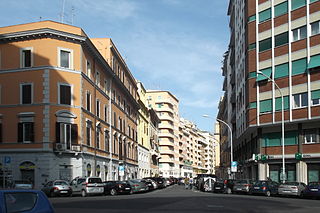
Over time Primavalle has become more linked to the city center, and is now considered as a semi-peripheral suburb. However, because of the widespread poverty and of the difficult conditions of the population in the past decades, the area is regarded as a petty crime borough. Moreover, during the so-called Anni di Piombo, Primavalle was the location of violent conflicts.
Geography
The territory of Primavalle includes the urban zones19BPrimavalle and 19DSanta Maria della Pietà, as well as portions of the urban zones 18BVal Cannuta and 18CFogaccia.
Boundaries
To the north, Primavalle borders with SuburbioDella Vittoria (S. XI), whose border is marked by the stretch of Via Trionfale between Via Vincenzo Chiarugi and Via della Pineta Sacchetti.
To the east, the quartiere borders with QuartiereTrionfale (Q. XIV), from which is separated by Via della Pineta Sacchetti. Eastward, Primavalle also borders with QuartiereAurelio (Q. XIII), whose boundary is marked by Via Domenico Tardini and Largo di Boccea.
Southward, it borders with SuburbioAurelio (S. IX), from which is separated by Largo di Boccea and Via di Boccea, up to Via di Torrevecchia.
Westward, Primavalle borders with SuburbioTrionfale (S. X), whose boundary is defined by Via di Torrevecchia, Via della Valle dei Fontanili, Via Giuseppe Guicciardi, by the Fosso dei Fontanili up to Via Cesare Lombroso, by Via Cesare Lombroso itself, Via Sebastiano Vinci, Piazza Santa Maria della Pietà and Via Vincenzo Chiarugi.
Odonymy
The majority of the streets and squares of Primavalle is named after religious figures, like popes and cardinals, and after psychiatrists and physicians, revealing the closeness of the borough both to the Vatican City, to the south-east, and to Santa Maria della Pietà, a former mental hospital, to the north. The odonyms of the quartiere can be categorized as follows:
Trastevere is the 13th rione of Rome: it is identified by the initials R. XIII and it is located within Municipio I. Its name comes from Latin trans Tiberim, literally 'beyond the Tiber'.
Sant'Eustachio is the 8th rione of Rome, identified by the initials R. VIII. It is named after the eponymous church and is located within the Municipio I.
Pigna is the 9th rione of Rome, identified by the initials R. IX, and belongs to the Municipio I. The name means "pine cone" in Italian, and the symbol of the rione is the colossal bronze pine cone standing in the middle of the homonymous fountain. The fountain, that was initially located in the Baths of Agrippa, now decorates a vast niche in the wall of the Vatican facing the Cortile della Pigna, located in Vatican City.
Campitelli is the 10th rione of Rome, identified by the initials R. X, and is located in the Municipio I.
Borgo is the 14th rione of Rome, Italy. It is identified by the initials R. XIV and is included within Municipio I.
Prati is the 22nd rione of Rome, identified by the initials R. XXII. It belongs to the Municipio I since 2013, while previously, along with Borgo and quartieri Trionfale and Della Vittoria, it was part of the Municipio XVII.
Monte Mario is the hill that rises in the north-west area of Rome (Italy), on the right bank of the Tiber, crossed by the Via Trionfale. It occupies part of Balduina, of the territory of Municipio Roma I, of Municipio Roma XIV and a small portion of Municipio Roma XV of Rome, thus including part of the Quarters Trionfale, Della Vittoria and Primavalle.
The Municipio XIX was an administrative subdivision of the city of Rome. Following the administrative reform of 11 March 2013, it was suppressed and merged into the new, and coextensive, Municipio XIV. Its territory is situated to the north-west part of the municipality of Rome.
La Storta is the 51st zona of the Italian capital city, Rome. It is identified by the initials Z. LI and falls within the boundaries of Municipio XV.
Portuense is the 11th quartiere of Rome (Italy), identified by the initials Q.XI.
Monte Sacro Alto is the 28th quartiere of the city of Rome in Italy, and it is identified by the initials Q. XXVIII. As a quarter, or second level administrative division, it is one of two that comprise the first level division or Municipality of Municipio III.
Tor Cervara is the 7th zona of the Italian capital Rome, identified by the initials Z. VII. It belongs to the Municipio IV and has 13,975 inhabitants (2016). It is located in the east of the city, within the Grande Raccordo Anulare, and has an area of 5.9000 km2.
Castel Giubileo is the second Zone of Rome in the Ager Romanus, identified as Z. II.
The Suburbi di Roma are the third level of toponomastic subdivision of the Municipality of Rome (Italy).
Tiburtino is the 6th quartiere of Rome (Italy), identified by the initials Q. VI. The name derives from the ancient road Via Tiburtina. It belongs to the Municipio II, Municipio IV and Municipio V.
Prenestino-Labicano is the 7th quartiere of Rome (Italy), identified by the initials Q. VII. The name derives from the ancient roads Via Prenestina and Via Labicana, today the initial stretch of Via Casilina. It belongs to the Municipio V and Municipio VII.
Tuscolano is the 8th quartiere of Rome (Italy), identified by the initials Q. VIII. The name derives from the ancient road Via Tuscolana. It belongs to the Municipio V and Municipio VII.
Gianicolense[dʒanikoˈlɛnse] is the 12th quartiere of Rome (Italy), identified by the initials Q. XII. It belongs to the Municipio XI and Municipio XII. It takes its name from the Janiculum hill, which lies in the nearby rione Trastevere and whose western extremities correspond to the area of Monteverde.
Aurelio is the 13th quartiere of Rome (Italy), identified by the initials Q. XIII. It belongs to the Municipio XIII and Municipio XIV.
Trionfale is the 14th quartiere of Rome (Italy), identified by the initials Q. XIV. The toponym also indicates the urban zone 19E of Municipio XIV.
References
↑ Roma Capitale – Roma Statistica. Population inscribed in the resident register at 31 December 2016 by toponymy subdivision.
This page is based on this Wikipedia article Text is available under the CC BY-SA 4.0 license; additional terms may apply. Images, videos and audio are available under their respective licenses.