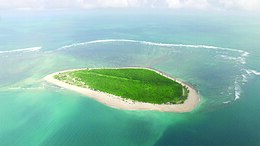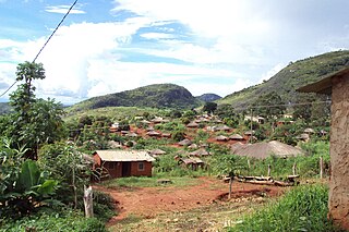
Zambezia is the second most-populous province of Mozambique, located in the central coastal region south-west of Nampula Province and north-east of Sofala Province. It has a population of 5.11 million, according to the 2017 census. The provincial capital is Quelimane.

The Philippine Sea is a marginal sea of the Western Pacific Ocean east of the Philippine Archipelago and the largest sea in the world, occupying an estimated surface area of 5 million square kilometers. The Philippine Sea Plate forms the floor of the sea. Its western border is the first island chain to the west, comprising the Ryukyu Islands in the northwest and Taiwan in the west. Its southwestern border comprises the Philippine islands of Luzon, Catanduanes, Samar, Leyte, and Mindanao. Its northern border comprises the Japanese islands of Honshu, Shikoku and Kyūshū. Its eastern border is the second island chain to the east, comprising the Bonin Islands and Iwo Jima in the northeast, the Mariana Islands in the due east, and Halmahera, Palau, Yap and Ulithi in the southeast. Its southern border is Indonesia's Morotai Island.
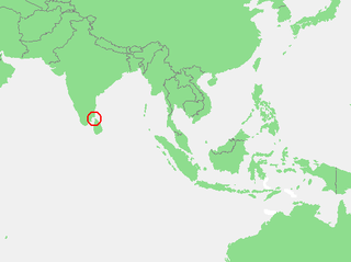
The Gulf of Mannar is a large shallow bay forming part of the Laccadive Sea in the Indian Ocean with an average depth of 5.8 m (19 ft). It lies between the southeastern tip of India and the west coast of Sri Lanka, in the Coromandel Coast region. The chain of low islands and reefs known as Adam’s Bridge or Rama Setu, which includes Mannar Island, separates the Gulf of Mannar from Palk Bay, which lies to the north between India and Sri Lanka. The estuaries of Thamirabarani River and Vaippar River of South India and the Malvathu Oya of Sri Lanka drain into the Gulf. The dugong is found here.

The Bazaruto Archipelago is a group of six islands in Mozambique, near the mainland city of Vilankulo. It comprises the islands of Bazaruto, Benguerra, Magaruque, Banque, Santa Carolina and Shell. Nyati Island is located further south.

The Coral Triangle (CT) is a roughly triangular area in the tropical waters around the Philippines, Indonesia, Malaysia, Papua New Guinea, the Solomon Islands and Timor-Leste. This area contains at least 500 species of reef-building corals in each ecoregion. The Coral Triangle is located between the Pacific and Indian oceans and encompasses portions of two biogeographic regions: the Indonesian-Philippines Region, and the Far Southwestern Pacific Region. As one of eight major coral reef zones in the world, the Coral Triangle is recognized as a global centre of marine biodiversity and a global priority for conservation. Its biological resources make it a global hotspot of marine biodiversity. Known as the "Amazon of the seas", it covers 5.7 million square kilometres (2,200,000 sq mi) of ocean waters. It contains more than 76% of the world's shallow-water reef-building coral species, 37% of its reef fish species, 50% of its razor clam species, six out of seven of the world's sea turtle species, and the world's largest mangrove forest. In 2014, the Asian Development Bank (ADB) reported that the gross domestic product of the marine ecosystem in the Coral Triangle is roughly $1.2 trillion per year and provides food to over 120 million people. According to the Coral Triangle Knowledge Network, the region annually brings in about $3 billion in foreign exchange income from fisheries exports, and another $3 billion from coastal tourism revenues.

The hawksbill sea turtle is a critically endangered sea turtle belonging to the family Cheloniidae. It is the only extant species in the genus Eretmochelys. The species has a global distribution that is largely limited to tropical and subtropical marine and estuary ecosystems.

The East African mangroves are a mangrove ecoregion consisting of swamps along the Indian Ocean coast of East Africa in Mozambique, Tanzania, Kenya and southern Somalia.

Madagascar mangroves are a coastal ecoregion in the mangrove forest biome found on the west coast of Madagascar. They are included in the WWF's Global 200 list of most outstanding ecoregions.
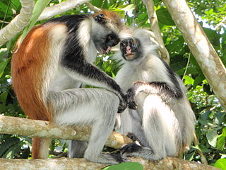
The wildlife of Zanzibar consists of terrestrial and marine flora and fauna in the archipelago of Zanzibar, an autonomous region of Tanzania. Its floral vegetation is categorized among the coastal forests of eastern Africa as the Southern Zanzibar-Inhambane coastal forest mosaic and the Northern Zanzibar-Inhambane coastal forest mosaic. Its faunal species are mostly small animals, birds, and butterflies.

The Menai Bay Conservation Area (MBCA) is located in Menai Bay, Zanzibar Tanzania. At 470 square kilometres (180 sq mi), it is Zanzibar's largest marine protected area. It was officially established as a conservation area in August 1997 in the traditional fishing area, known as Unguja Island, covering the tropical marine environment comprising extensive coral reefs, tropical fish, sea grasses, and mangrove forests. In addition to controlling illegal fishing, MBCA's alternative initiatives have included bee keeping, mangrove replanting, tree nurseries and tourism. The management of the MBCA falls upon the Fisheries Department and the bay's local villages. It is rated by the IUCN as Category VI Managed Resource Protected Area.

The Bazaruto Archipelago National Park (BANP) is a protected area in the Inhambane Province of Mozambique on the Bazaruto Archipelago. The park was proclaimed on 25 May 1971. It is off the coast of the Vilanculos and Inhassoro districts, covering a large expanse of ocean and six islands.

The Quirimbas National Park (QNP)(Hifadhi ya Taifa ya Kirimba, in Swahili) is a protected area in the Cabo Delgado Province of Mozambique, encompassing the southern part of the Quirimbas Islands, as well as a significant mainland area. The mainland region of Taratibua contain various inselbergs.

The Lampi Island Marine National Park is a marine national park in Myanmar covering 79.09 sq mi (204.8 km2). It was established in 1996. It encompasses Lanbi Island and several smaller islands in the Mergui Archipelago, comprising coral reefs, seagrass beds, mangroves, sand dunes and tropical evergreen forest up to an elevation of 1,493 ft (455 m). The national park is an Important Bird Area and one of the ASEAN Heritage Parks. Access is restricted to day-time visits.
The St. Croix East End Marine Park (STXEEMP) was established to "protect territorially significant marine resources, and promote sustainability of marine ecosystems, including coral reefs, sea grass beds, wildlife habitats and other resources, and to conserve and preserve significant natural areas for the use and benefit of future generations." It is the U.S. Virgin Islands’ first territorially designated and managed marine protected area (MPA).
The East African coral coast is a marine ecoregion along the eastern coast of Africa. It extends along the coasts of Kenya, Tanzania, and northern Mozambique, from Lamu in Kenya to Angoche in Mozambique. It adjoins the Northern Monsoon Current Coast ecoregion to the north, and the Bight of Sofala/Swamp Coast ecoregion to the south.

Delagoa is a marine ecoregion along the eastern coast of Africa. It extends along the coast of Mozambique and South Africa from the Bazaruto Archipelago to Lake St. Lucia in South Africa in South Africa's Kwazulu-Natal province. It adjoins the Bight of Sofala/Swamp Coast ecoregion to the north, and the Natal ecoregion to the south. It has Africa's southernmost tropical coral reefs and mangrove forests. It is the southernmost Indo-Pacific ecoregion, marking the transition from the tropical Indo-Pacific to Temperate Southern Africa.
The Northern Monsoon Current coast is a marine ecoregion along the eastern coast of Africa. It extends along a portion of the coasts of Somalia and Kenya, from south of Lamu in Kenya to north of Mogadishu in Somalia. It adjoins the Central Somali coast ecoregion to the north, and the East African coral coast ecoregion to the south.

The Mayotte Marine Natural Park is a marine park surrounding Mayotte, a French overseas region. Mayotte is part of the Comoro Islands archipelago, which lies within the Mozambique Channel in the western Indian Ocean. Established in 2010, the park covers the entirety of Mayotte's territorial waters and exclusive economic zone. It is contiguous with the Glorioso Islands Marine Natural Park, which was established two years later.
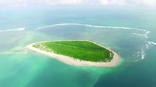
Ilha do Fogo, or Fire Island, is a remote, 3.5 km circumference island off the Zambezia Province coastline in northern Mozambique. It forms part of the Primeiras and Segundas Archipelago, within Africa's most extensive coastal marine protected area. The private island is encircled by coral-rich reefs on the island's south side and seagrasses on the north. It has 150 km of unexplored reef, with abundant and diverse marine life.
Kwale Island also known as Kuvala Island is a historic island located in Kisiju ward of Mkuranga District in southern Pwani Region of Tanzania. 7.1 square kilometres is the size of Kwale Island.
