Prince-Garibaldi Building

Last updated
Prince-Garibaldi Building
USA California location map.svg
Red pog.svg
Location of Prince-Garibaldi Building in California
Usa edcp location map.svg
Red pog.svg
Prince-Garibaldi Building (the United States)
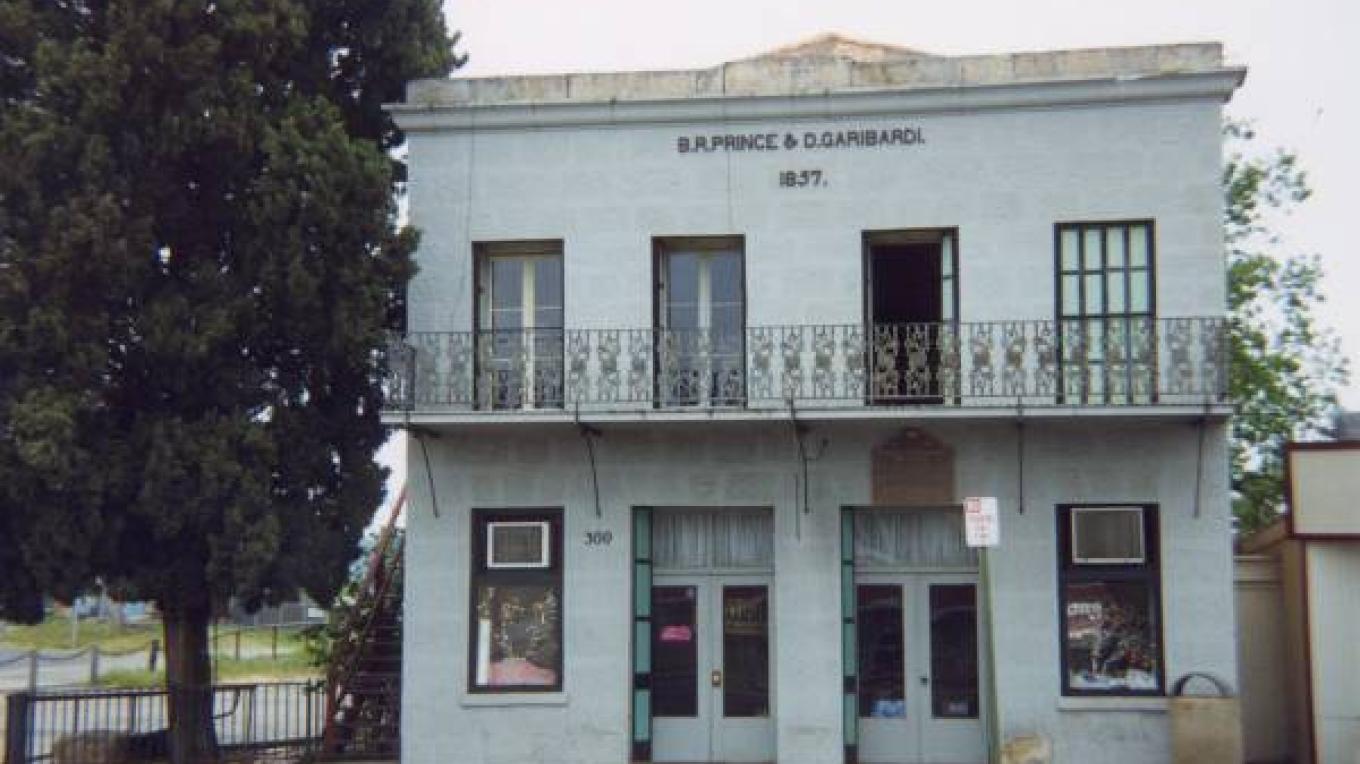
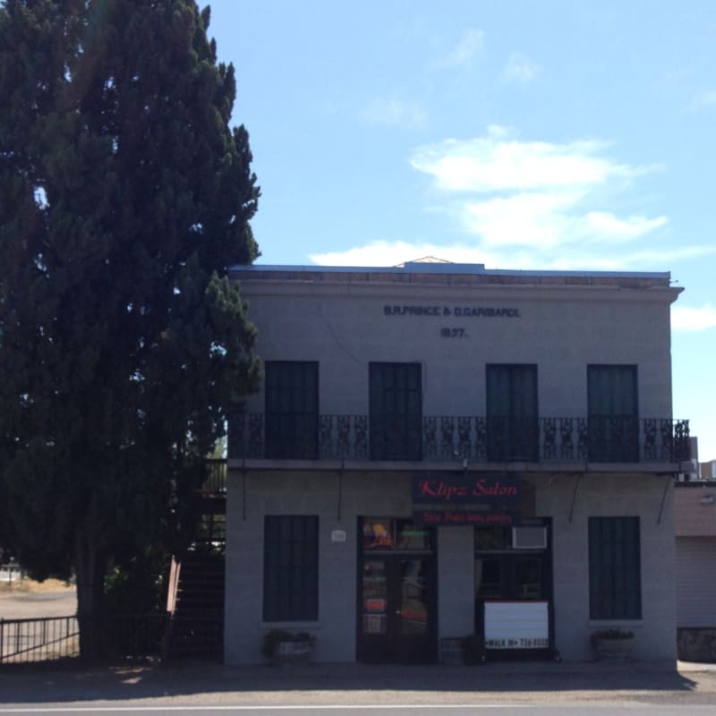
Location4298 Main Street
Altaville, California
Coordinates 38°04′45″N120°33′15″W / 38.079117°N 120.554199°W / 38.079117; -120.554199
Built1852
Reference no.735

Prince-Garibaldi Building is a historical building in Altaville, California in Calaveras County. Altaville, California is just north of the town of Angels Camp. The building was built by B. R. Prince and G. Garibardi in 1852 as a general store on the first floor. The building is built built by David Strosberger out of rhyolite tuff stones designed. In 1857 a second floor was added and used for the store owner's living space. For a time the building was the Prince Undertaking Parlor with a plumed horse hearse. [1] [2] The Prince-Garibaldi Building is a California Historical Landmark No. 735 of California State Route 49. [3] [4] [5]

Contents

Bartholomew Romaggi Prince, B. R. Prince, Bartolo Prince, was born on March 7, 1829, in Romaggi, Liguria, Italy. He came to California in 1852. He married Mary Ann Hanratty (1839-1890) born in Northern Ireland died in Altaville. Prince and Garabardi opened the goods store in Altaville. Later he opened a quartz mine looking for gold in the California Gold Rush. Prince opened and ran the Altaville Hotel (on Murphys Road), livery stable (Prince's Livery and Feed on Angels Camp Rd. and San Andreas Rd., now the site of Altaville Aquatic Center), the Murphys Toll Road (now Grade Road), and undertaking parlor. For a time he ran a silkworm firm, the silk he sold to Italy. His silk won prizes at the local Calaveras County Fair. Prince owned most of the town's commercial firm for 47 years. When he retired he moved to Stockton, California, he died June 7, 1905, at age 76. Edward R. Prince, Frank R. Prince, Tessie R. [Prince] Favinger, Mary L. Buhrer, Lawrence G. Preston [AKA Goldstone], Bartolo and Mary Prince children and inlaws were: Frank Romaggi Prince (1861–1907), Dante Prince (1864–1911), Mary Romaggi Prince Fischer (1866–1920), Domingo Romaggi Prince (1868–1890), Joseph Romaggi Prince (1873–1923), Theresa Romaggi Prince Favinger (1873–1962) and Edward Romaggi Prince (1875–1945). [6] [7] [8]

See also

Related Research Articles

<span class="mw-page-title-main">Calaveras County, California</span> County in California, United States

Calaveras County, officially the County of Calaveras, is a county in both the Gold Country and High Sierra regions of the U.S. state of California. As of the 2020 census, the population was 45,292. The county seat is San Andreas. Angels Camp is the county's only incorporated city. Calaveras is Spanish for "skulls"; the county was reportedly named for the remains of Native Americans discovered by the Spanish explorer Captain Gabriel Moraga.

<span class="mw-page-title-main">Angels Camp, California</span> City in California, United States

Angels Camp, also known as City of Angels and formerly Angel's Camp, Angels, Angels City, Carson's Creek and Clearlake, is the only incorporated city in Calaveras County, California, United States. The population was 3,836 at the 2010 census, up from 3,004 at the 2000 census. It lies at an elevation of 1378 feet.

<span class="mw-page-title-main">Murphys, California</span> Census designated place in California, United States

Murphys, originally Murphys New Diggings then Murphy's Camp, is an unincorporated village located in the foothills of the Sierra Nevada mountains in Calaveras County, California, United States. The population was 2,213 at the 2010 census, up from 2,061 at the 2000 census.

<span class="mw-page-title-main">Fort Bridger</span> United States historic place

Fort Bridger was originally a 19th-century fur trading outpost established in 1842, on Blacks Fork of the Green River, in what is now Uinta County, Wyoming, United States. It became a vital resupply point for wagon trains on the Oregon Trail, California Trail, and Mormon Trail. The Army established a military post here in 1858 during the Utah War, until it was finally closed in 1890. A small town, Fort Bridger, Wyoming, remains near the fort and takes its name from it.

<span class="mw-page-title-main">Native Sons of the Golden West</span> Fraternal service organization in California, United States

The Native Sons of the Golden West (NSGW) is a fraternal service organization founded in the U.S. state of California in 1875, dedicated to historic preservation and documentation of the state's historic structures and places, the placement of historic plaques, and other charitable functions in California. In 1890 the organization placed California's first marker honoring the discovery of gold, which gave rise to the state nickname, "The Golden State". U.S. President Richard M. Nixon and Chief Justice Earl Warren served terms as presidents of the NSGW.

<span class="mw-page-title-main">California State Route 49</span> Highway in California

State Route 49 is a north–south state highway in the U.S. state of California that passes through many historic mining communities of the 1849 California gold rush and it is known as the Golden Chain Highway. The highway's creation was lobbied by the Mother Lode Highway Association, a group of locals and historians seeking a single highway to connect many relevant locations along the Gold Rush to honor the 49ers. One of the bridges along SR 49 is named for the leader of the association, Archie Stevenot.

Kingston is a former town that was originally in Fresno County, until 1909 when that territory south of Kings River was transferred to Kings County, California. It was located on the south bank of the Kings River 8.5 miles (13.7 km) northwest of Hanford at Whitmore's Ferry.

<span class="mw-page-title-main">Marshall Gold Discovery State Historic Park</span> State park in California

Marshall Gold Discovery State Historic Park is a state park of California, United States, marking the discovery of gold by James W. Marshall at Sutter's Mill in 1848, sparking the California Gold Rush. The park grounds include much of the historic town of Coloma, California, which is now considered a ghost town as well as a National Historic Landmark District. The park contains thre California Historical Landmarks: a monument to commemorate James Marshall (#143), the actual spot where he first discovered gold in 1848 (#530). Established in 1942, and Coloma Road (#748),. The park now comprises 576 acres (233 ha) in El Dorado County.

<span class="mw-page-title-main">Knights Ferry, California</span> Unincorporated community in California, United States

Knights Ferry is an unincorporated historic community in Stanislaus County, California, United States. Nestled in the foothills of the Sierra Nevada, it is about 30 miles (48 km) east of Modesto on the Stanislaus River. The Willms Ranch near the town was one of many filming locations for the television series Bonanza and Little House on the Prairie.

<span class="mw-page-title-main">Mount Saint Mary's Convent and Academy</span> United States historic place

Mount Saint Mary's Convent and Academy, originally the Sacred Heart Convent and Holy Angels Orphanage and previously Mount St. Mary's Convent and Orphan Asylum, and also known as Mount Saint Mary's Academy and Convent, is the only extant original orphanage in California and commemorates the Sisters of Mercy, in Grass Valley, Nevada County, California.

<span class="mw-page-title-main">Rensselaer D. Hubbard House</span> Historic house in Minnesota, United States

The Rensselaer D. Hubbard House, is a historic house in Mankato, Minnesota, United States. Originally a private home, it is currently a museum. The building was placed on the National Register of Historic Places on June 7, 1976.

<span class="mw-page-title-main">Immanuel Presbyterian Church (Milwaukee, Wisconsin)</span> Historic church in Wisconsin, United States

Immanuel Presbyterian Church is a High Victorian Gothic-styled church built 1873–75 in Milwaukee, Wisconsin. In 1974 it was added to the National Register of Historic Places. Additionally, it was designated a landmark by the Milwaukee Landmarks Commission in 1969.

<span class="mw-page-title-main">Lohman Funeral Home and Livery Stable</span> United States historic place in Milwaukee, Wisconsin

The Lohnam Funeral Home and Livery Stable are located in Milwaukee, Wisconsin. In 1988, the site was added to the National Register of Historic Places. According to its application, it is an "example of a 19th century commercial livery stable in the day".

<span class="mw-page-title-main">Bella Union Hotel</span> Historic site in East of Temple and Main streets, where Fletcher Bowron Square is today

The Bella Union Hotel in Los Angeles, California, constructed in 1835, is California Historical Landmark No. 656. It was effectively the last capitol building of Mexican California under Governor Pio Pico, in 1845–47, and was a center of social and political life for decades. The hotel was located at N. Main Street, on the east side, a few doors north of Commercial Street, which then ran east–west between Arcadia and Temple. The hotel was later known as the Clarendon and then as the St. Charles.

<span class="mw-page-title-main">Old Town Irvine</span> California historic landmark

Old Town Irvine was designated a California Historic Landmark (No.1004) on November 11, 1991. Old Town Irvine is in the city of Irvine, California in Orange County A Historic marker is at 14980 Sand Canyon Avenue, Irvine. The marker is to remember the founding the City of Town Irvine in 1887. The town of Irvine started as a train stop for the Santa Fe Railroad in 1889, where barley warehouse was built. At the time of founding the town was called Myford, California. Myford was the youngest son of James H. Irvine, who the town would be renamed after. James Irvine called the new town Myford, as at the time there was a City of Irvine in Calaveras County in Northern California. Myford was renamed Irvine in 1914, as the Northern California town changed its name to Carson Hill. The 125,000-acre Irvine Ranch was the largest employer in the town for years, a very busy place during harvest time. The town had a school, general store, blacksmith shop, diner, and a hotel for seasonal workers, all around Central Avenue and the train station. The Ranch lost its place as the center of town in the 1960s, with the housing boom and a new town center was built up. Irvine incorporated as a city in 1971. The old portions of Irvine, renamed East Irvine, had become run down. Much of the old Ranch in East Irvine was abandoned or taken down. Central Avenue was renamed Sand Canyon Ave, which became a main highway. The 1980 plan to make Sand Canyon Ave wider threaten some of the Historic Landmarks in Irvine. A Historic Preservation Committee was formed and the town worked to save Old Town Irvine. The City of Irvine working with the Sand Canyon Historical Partners and the Irvine Historical Society, they came up with a plan to reuse some of the old buildings.

<span class="mw-page-title-main">Pine Inn</span> Historic hotel in California, U.S.

Pine Inn, once called the Hotel Carmelo, is one of the early first-class Arts and Crafts, Tudor, Spanish style hotels established in Carmel-by-the-Sea, California. The Pine Inn is a historical resource dating back to 1889 when pioneer Santiago J. Duckworth built Hotel Carmelo. James Franklin Devendorf, renamed the hotel the "Pine Inn" in 1904. Today, it is a full-service hotel. The Pine Inn qualified for inclusion in the city's Downtown Historic District Property Survey, and was registered with the California Register of Historical Resources on March 18, 2003. The Inn is significant under the California Register criterion 1, as the first hotel in the history of the downtown district of Carmel-by-the-Sea.

Alfred Douglas Price, Sr. (1860–1921) also known as A. D. Price, was an African American businessman and community leader in the late 19th-century and early 20th-century in Richmond, Virginia. He owned a blacksmith shop, funeral home, and a livery. Price was one of the largest African American real estate owners in his city and the A.D. Price Funeral Home is now a national historic site.

The site of the Old Mining Camp of Brownsville is a California Historical Landmark on Pennsylvania Gulch Road east of the town of Murphys, California in Calaveras County. The Mining Camp of Brownsville was a California Gold Rush camp in Pennsylvania Gulch in from 1850 to 1870. The camp is named after Alfred Brown, who was the former owner of the Table Mountain Ranch. There were many rich mines in the area and Brownsville Mining Camp supported this activity. So rich was the area, the Brownsville Mining District limited the size of mines in the District. Each miner could claim and own only one wet and one dry site, no larger than 150 square feet each. Brownsville Mining District was in the area of Pennsylvania Gulches and Missouri Gulches 2 miles from Murphys. There are no remains of the camp, but nearby is the Brownsville Mining District Cemetery. A plaque monument was dedicated on July 19, 1953, by California State Park Commission with the monument base built by Christa Parlor No. 137 and Ruby Parlor No. 49 of the Native Daughters of the Golden West.

Robinson's Ferry is a historical site in Angels Camp, California in Calaveras County. John W. Robinson and Stephen Mead founded a ferry in 1848. The ferry crossed the river, where New Melones Lake is now. The New Melones Lake Bridge now crosses where the ferry was. The ferry was used to move California Gold Rush miners, their cargo and animals across the river. Harvey Wood purchased the ferry in 1856. The fare to cross was 50 cents for each person or animal crossing. The site of Robinson's Ferry a California Historical Landmark No. 276. A marker is on California State Route 49 near the bridge across New Melones Lake. The historical marker was placed there in 1949 by California Centennial Commission, and the base was built Angels Camp Lions Club. The Marker is 5.6 miles south of Angels Camp and 0.3 miles north of New Melones Lake Reservoir.

References

  1. Prince-Garibaldi Buildingmalakoff.com
  2. plumed hearse photo
  3. "PRINCE-GARIBARDI BUILDING". CA State Parks.
  4. "Prince-Garibardi Building Historical Marker". www.hmdb.org.
  5. "Prince-Garibardi Building (No. 735 California Historical Landmark) | Sierra Nevada Geotourism". sierranevadageotourism.org.
  6. Calaveras Co Historical Society and 1888-1896
  7. https://www.calaverashistory.org/history-under-the-bret-harte-pool
  8. (Buckbee 1922:47-48; Sanborn 1890, 1895, 1905)