The area is home to two public parks, Giblin Reserve and Prince of Wales Bay Reserve. It is also home to a softball/baseball ground and hockey courts.
It was the site of the first military encampment in Hobart.[1]
Like its neighbouring suburb, Derwent Park, Prince of Wales Bay is home to light industry,[2] and contains few houses. It is also the location of Catamaran construction company Incat.
Hobart is the capital and most populous city of the Australian island state of Tasmania. Home to almost half of all Tasmanians, it is the least-populated Australian state capital city, and second-smallest if territories are taken into account, before Darwin, Northern Territory. Hobart is located in Tasmania's south-east on the estuary of the River Derwent, making it the most southern of Australia's capital cities. Its skyline is dominated by the 1,271-metre (4,170 ft) kunanyi/Mount Wellington, and its harbour forms the second-deepest natural port in the world, with much of the city's waterfront consisting of reclaimed land. The metropolitan area is often referred to as Greater Hobart, to differentiate it from the City of Hobart, one of the five local government areas that cover the city. It has a mild maritime climate.
The River Derwent is a river located in Tasmania, Australia. It is also known by the palawa kani name timtumili minanya. The river rises in the state's Central Highlands at Lake St Clair, and descends more than 700 metres (2,300 ft) over a distance of more than 200 kilometres (120 mi), flowing through Hobart, the state's capital city, before emptying into Storm Bay and flowing into the Tasman Sea. The banks of the Derwent were once covered by forests and occupied by Aboriginal Tasmanians. European settlers farmed the area and during the 20th century many dams were built on its tributaries for the generation of hydro-electricity.
Mount Wellington, officially kunanyi / Mount Wellington, is a mountain in the southeast of Tasmania, Australia. It is the summit of the Wellington Range and is within Wellington Park reserve. Hobart, Tasmania's capital city, is located at the foot of the mountain.
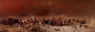
The history of Tasmania begins at the end of the most recent ice age when it is believed that the island was joined to the Australian mainland. Little is known of the human history of the island until the British colonisation in the 19th century.
Risdon Cove is a cove located on the east bank of the Derwent River, approximately 7 kilometres (4 mi) north of Hobart, Tasmania. It was the site of the first British settlement in Van Diemen's Land, now Tasmania, the island state of Australia. The cove was named by John Hayes, who mapped the river in the ship Duke of Clarence in 1794, after his second officer William Bellamy Risdon.
Glenorchy City Council is a local government body in Tasmania, and one of the five municipalities that constitutes the Greater Hobart Area. The Glenorchy local government area has a population of 47,636, covering the suburbs north of central Hobart on the western shore of the Derwent River, including its namesake suburb, Glenorchy.
The Division of Denison was an Australian electoral division in Tasmania, before being replaced by the Division of Clark as part of a 2016–17 redistribution.
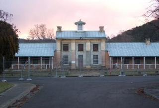
Derwent Barracks is an Australian Army barracks in the Hobart suburb of Glenorchy, near the Elwick Racecourse and Hobart Showgrounds. It is named after the nearby Derwent River. It is the home of several Army Reserve units including:
Fahan School is an independent school for girls located in Sandy Bay, a suburb of Hobart, Tasmania, Australia. It is a non-denominational school with a Christian ethos.
Derwent Park is a residential locality in the local government area (LGA) of Glenorchy in the Hobart LGA region of Tasmania. The locality is about 2 kilometres (1.2 mi) east of the town of Glenorchy. The 2016 census recorded a population of 657 for the state suburb of Derwent Park. It is a suburb of Hobart.
Dowsing Point is a residential locality in the local government area (LGA) of Glenorchy in the Hobart LGA region of Tasmania. The locality is about 2 kilometres (1.2 mi) north-east of the town of Glenorchy. The 2016 census recorded a population of 85 for the state suburb of Dowsing Point.
The Royal Hobart Regatta is a series of aquatic competitions and displays held annually in Hobart, Tasmania, Australia and is Tasmania's oldest sporting event.
Cadbury's Chocolate Factory is a working chocolate factory belonging to the Australian division of international confectionery company Cadbury, and is located in Claremont, Tasmania. Despite being an active production facility, Cadbury's Claremont has a rich history with 18 heritage listed buildings on the site. The factory still features pure granite "conching" machines which are over 60 years old but are still in use. Due to its long history, and the general appeal of chocolate, the factory was a major Tasmanian tourism attraction for families until its on-site visitor centre closed in 2015.
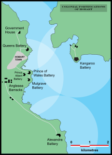
The Hobart coastal defences are a network of now defunct coastal batteries, some of which are inter-linked with tunnels, that were designed and built by British colonial authorities in the nineteenth century to protect the city of Hobart, Tasmania, from attack by enemy warships. During the nineteenth century, the port of Hobart Town was a vital re-supply stop for international shipping and trade, and therefore a major freight hub for the British Empire. As such, it was considered vital that the colony be protected. In all, between 1804 and 1942 there were 12 permanent defensive positions constructed in the Hobart region.
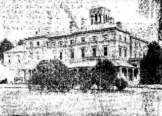
The Royal Derwent Hospital, was built to house mentally ill and mentally handicapped persons in 1827, soon after the separation of Van Diemens Land from New South Wales. Its name was changed on 27 March 1968 to the Royal Derwent Hospital., also absorbing the nearby Millbrook Rise facility on 1 July 1968 to house patients. It was open for more than 170 years, finally closing in November 2000.
The 6th Military District was an administrative district of the Australian Army. During the Second World War, the 6th Military District covered all of Tasmania, with its headquarters at Hobart.
Mona Vale is a large heritage listed 1860s country house in Ross, Tasmania. Completed in 1867, it is well locally known as the "Calendar House", for its reportedly 365 windows, 52 rooms, 12 chimneys and seven entrances. The property is on the Tasmanian Heritage Register and the Register of the National Estate.
South Arm Peninsula is a peninsula that lies on the east side of the mouth of the River Derwent south of Hobart in Tasmania, Australia. The peninsula commences at Lauderdale and curves landward or inward on a narrow isthmus that has South Arm situated on the east side of the Derwent, across from Blackmans Bay on the west side. Opossum Bay is the northernmost populated place on the northward curve.
The Port of Hobart is situated on the Derwent River, as the port of Hobart, Tasmania, Australia.
The electoral division of Clark is one of the five electorates in the Tasmanian House of Assembly, it is located in Hobart on the western shore of the River Derwent and includes the suburbs below Mount Wellington. Clark is named after Andrew Inglis Clark, a Tasmanian jurist who was the principal author of the Australian Constitution. The electorate shares its name and boundaries with the federal division of Clark.
This page is based on this Wikipedia article Text is available under the CC BY-SA 4.0 license; additional terms may apply. Images, videos and audio are available under their respective licenses.