
The Northwest Territories is a federal territory of Canada. At a land area of approximately 1,144,000 km2 (442,000 sq mi) and a 2016 census population of 41,790, it is the second-largest and the most populous of the three territories in Northern Canada. Its estimated population as of 2020 is 45,161. Yellowknife is the capital, most populous community, and only city in the territory with a population of 19,569 as of the 2016 census. It became the territorial capital in 1967, following recommendations by the Carrothers Commission.
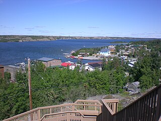
Yellowknife is the capital, only city, and largest community in the Northwest Territories, Canada. It is on the northern shore of Great Slave Lake, about 400 km (250 mi) south of the Arctic Circle, on the west side of Yellowknife Bay near the outlet of the Yellowknife River.

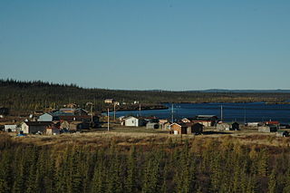
Tsiigehtchic, officially the Charter Community of Tsiigehtchic, is a Gwich'in community located at the confluence of the Mackenzie and the Arctic Red Rivers, in the Inuvik Region of the Northwest Territories, Canada. The community was formerly known as Arctic Red River, until 1 April 1994. The Gwichya Gwich'in First Nation is located in Tsiigehtchic.

Fort Resolution is a hamlet in the South Slave Region of the Northwest Territories, Canada. The community is situated at the mouth of the Slave River, on the shores of Great Slave Lake, and at the end of the Fort Resolution Highway. It is the headquarters of the Deninu Kųę́ First Nation, whose Chief is Louis Balsillie.

Dettah, sometimes, incorrectly, as Detah, is a First Nations community in the North Slave Region of the Northwest Territories, Canada. Located just southeast of the capital of Yellowknife, it is a 6.5 km (4.0 mi) drive from that city by ice road across the north arm of Great Slave Lake in winter or a 27 km (17 mi) drive via the Ingraham Trail, year-round. The name means 'Burnt Point' in the Tli Cho language and refers to a traditional fishing camp used by the Dene for hundreds of years.

Norman Wells is the regional centre for the Sahtu Region of the Northwest Territories (NWT), Canada. The town is situated on the north side of the Mackenzie River and provides a view down the valley of the Franklin and Richardson mountains.

Ulukhaktok is a small hamlet on the west coast of Victoria Island, in the Inuvik Region of the Northwest Territories, Canada.
Colville Lake is a settlement corporation located in the Sahtu Region of the Northwest Territories, Canada. The community is located 50 km (31 mi) north of the Arctic Circle, on a lake of the same name, and is northeast of Norman Wells. This settlement is the administrative office of the Behdzi Ahda band government.

Nahanni Butte is a "Designated Authority" in the Dehcho Region of the Northwest Territories, Canada. The community is located at the confluence of the Liard and South Nahanni Rivers in the southwestern part of the NWT.
Jean Marie River is a "Designated Authority" in the Dehcho Region of the Northwest Territories, Canada. The community is located on the Jean Marie River where it joins the Mackenzie River. The community has a small airport, Jean Marie River Airport, and is accessible by charter aircraft throughout the year and by the all-season JMR Access Road 27 km (17 mi) from the Mackenzie Highway.

Behchokǫ̀, officially the Tłı̨chǫ Community Government of Behchokǫ̀, is a community in the North Slave Region of the Northwest Territories, Canada. Behchokǫ̀ is located on the Yellowknife Highway, on the northwest tip of Great Slave Lake, approximately 110 km (68 mi) northwest of Yellowknife.

Gamètì, officially the Tłı̨chǫ Community Government of Gamètì is a community in the North Slave Region of the Northwest Territories, Canada. Gamètì, according to the Prince of Wales Northern Heritage Centre means "rabbit-net lake". 'Gamè' means 'rabbit', and 'tì' means lake, or water. It is one of the four Tłı̨chǫ communities which form part of the Tlicho Government.

Kakisa is a "Designated Authority" in the South Slave Region of the Northwest Territories, Canada. The community is located on Kakisa Lake, and is southeast of Fort Providence. Originally located at Tathlina Lake, the community moved, in 1962, to the present location in order to be closer to the Mackenzie Highway and is linked by a 13 km (8.1 mi) all-weather road.
Old Fort Providence, located near the mouth of Yellowknife Bay, Northwest Territories, Canada, was one of the first fur trading outposts on Great Slave Lake. Peter Pond of the North West Company first proposed trading with the Dene around Great Slave Lake in 1786. In 1789, Alexander Mackenzie initiated a period of trade with the Yellowknives and Tłı̨chǫ Dene and instructed his assistant, Laurent Leroux, to start a trading post in this area. The post was not a major centre for fur trading and was used primarily as a supply centre for other, more important trading posts or expeditions. It served, for example, as a base of supply for Sir John Franklin's Coppermine expedition towards the Arctic Ocean in 1820. It was located within a productive fishery used for generations by the Dene around Yellowknife Bay and helped supply meat and fish for traders at Great Slave Lake. The Hudson's Bay Company took over the post in 1821 after the demise of the North West Company, but the settlement was in decline and it closed in 1823. The buildings have long since decayed but the ruins were excavated in 1969-1971.

The North Slave Region or Tłicho Region is one of five administrative regions in the Northwest Territories of Canada. It is the most populous of the five regions, with a population of almost 23,000. According to Municipal and Community Affairs the region consists of eight communities with the regional offices situated in Behchokǫ̀ and Yellowknife. With the exception of Yellowknife, the communities are predominantly First Nations.

The Yellowknife Education District No. 1 is the public school board in Yellowknife, Northwest Territories. The district, then called Yellowknife School District No. 1, was created 1 October 1939 by Charles Camsell who was Commissioner of the Northwest Territories.
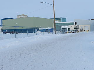
The Northern Arts and Cultural Centre is located in Yellowknife, Northwest Territories, Canada. It is the only performing arts centre in the NWT.
This timeline of Yellowknife history summarises key events in the history of Yellowknife, a city in the Northwest Territories, Canada.
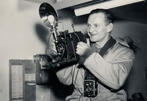
Henry Busse was an amateur photographer, who, while working at the Eldorado Mine, in remote Port Radium, took photos of high enough quality he was encouraged to become a professional photographer. He was the first professional photographer in the Northwest Territories. In 1961 the Northern News Service reported he had been named as one of Canada's 50 most important photographers.


