
The Toronto waterfront is the lakeshore of Lake Ontario in the city of Toronto, Ontario, Canada. It spans 46 kilometres between the mouth of Etobicoke Creek in the west and the Rouge River in the east.

Sullivans Cove is on the River Derwent adjacent to the Hobart City Centre in Tasmania. It was the site of initial European settlement in the area, and the location of the earlier components of the Port of Hobart.

Toronto Harbour or Toronto Bay is a natural bay on the north shore of Lake Ontario, in Toronto, Ontario, Canada. Today, the harbour is used primarily for recreational boating, including personal vessels and pleasure boats providing scenic or party cruises. Ferries travel from docks on the mainland to the Islands, and cargo ships deliver aggregates and raw sugar to industries located in the harbour. Historically, the harbour has been used for military vessels, passenger traffic and cargo traffic. Waterfront uses include residential, recreational, cultural, commercial and industrial sites.
The Embarcadero in San Diego, California, is the area along the San Diego harbor on the east side of San Diego Bay. "Embarcadero" is a Spanish word meaning "boarding place". The Embarcadero sits on property administered by the Port of San Diego, in the Columbia district of downtown San Diego.

The Port of San Francisco is a semi-independent organization that oversees the port facilities at San Francisco, California, United States. It is run by a five-member commission, appointed by the Mayor subject to confirmation by a majority of the Board of Supervisors. The Port is responsible for managing the larger waterfront area that extends from the anchorage of the Golden Gate Bridge, along the Marina district, all the way around the north and east shores of the city of San Francisco including Fisherman's Wharf and the Embarcadero, and southward to the city line just beyond Candlestick Point. In 1968, the State of California, via the California State Lands Commission for the State-operated San Francisco Port Authority, transferred its responsibilities for the Harbor of San Francisco waterfront to the City and County of San Francisco / San Francisco Harbor Commission through the Burton Act AB2649. All eligible State port authority employees had the option to become employees of the City and County of San Francisco to maintain consistent operation of the Port of San Francisco.
Transport in Auckland, New Zealand's largest city, is defined by factors that include the shape of the Auckland isthmus, the suburban character of much of the urban area, a history of focusing investment on roading projects rather than public transport, and high car-ownership rates.

Barangaroo is an area of central Sydney, Australia. It is at the north-western edge of the Sydney central business district and the southern end of the Sydney Harbour Bridge. It is part of the local government area of the City of Sydney. The area was used for fishing and hunting by Indigenous Australians prior to colonial settlement. The area is inclusive of The Hungry Mile, the name harbourside workers gave to the docklands area of Darling Harbour East during The Great Depression, where workers would walk from wharf to wharf in search of a job, often failing to find one.
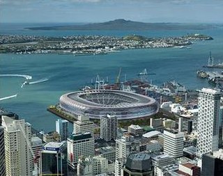
Stadium New Zealand, often called the Waterfront Stadium, was the provisional name for a national stadium proposed for the Auckland waterfront to host the 2011 Rugby World Cup. The stadium never advanced beyond a concept design.

The Finger Wharf is a heritage-listed former wharf and passenger terminal and now marina, residential apartments, hotel and restaurant located at 6 Cowper Wharf Road, in the inner city Sydney suburb of Woolloomooloo, Australia. It was designed by Henry D. Walsh and built from 1910 to 1915 by the Sydney Harbour Trust. It is also known as Woolloomooloo Finger Wharf and Woolloomooloo Wharf. The property is owned by Transport for NSW. The structure is the longest timbered-piled wharf in the world.

Ports of Auckland Limited (POAL), the successor to the Auckland Harbour Board, is the Auckland Council-owned company administering Auckland's commercial freight and cruise ship harbour facilities. As the company operates all of the associated facilities in the Greater Auckland area, this article is about both the current company and the ports of Auckland themselves.

The Wynyard Quarter is a reclaimed piece of land on the Waitematā Harbour at the western edge of the Auckland waterfront, New Zealand.

The Auckland waterfront is a city-side stretch of the southern Waitematā Harbour coastline in Auckland, New Zealand. Previously mostly dominated by Ports of Auckland uses, from the 2000s on it is becoming increasingly open to recreational public use, with a number of former wharves being converted to office, entertainment, and later also some residential uses.
The Port of Tauranga is situated in Tauranga, New Zealand. It is the largest port in the country both in terms of total cargo volume, and in terms of container throughput with container volumes exceeding 1.2 million TEUs. The port is operated by Port of Tauranga Ltd. This article is about both the company and the port itself.
Queens Wharf is a concrete wharf in Auckland, New Zealand, that continues off Queen Street. It opened in 1913, replacing the Queen Street Wharf, a succession of wooden wharves first built in 1852. Queens Wharf was owned and used by Ports of Auckland until 2010.

The Cloud is a multi-purpose event venue located on Queen's Wharf on the Auckland waterfront, in Auckland, New Zealand. Built as one of the centrepieces of the hospitality and 'party zone' facilities for the 2011 Rugby World Cup, it can host up to 6,000 people, and was originally expected to cost $NZ7.9 million. It was designed by Jasmax and built by Fletcher Construction.

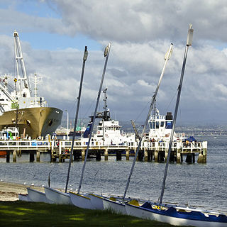
The Brooke Street Pier is a floating pontoon building at Sullivans Cove in the waterfront area of the city of Hobart, Tasmania, Australia. It was constructed in 2014–15 at a cost of A$13 million. It weighs 5,300 tonnes and was Australia's largest floating building upon completion. It is connected to the Hobart shore at Franklin Wharf, near the base of Brooke Street. Primarily a ferry terminal, the architect has described it as a "tourism transport hub".

The Overseas Passenger Terminal (OPT), known officially as the Sydney Cove Passenger Terminal, is a public passenger terminal servicing cruise ships and ocean liners located in Circular Quay, Sydney, Australia. Whilst commercial shipping operations on and around the site date from 1792, the current primary structure and waterfront promenade date from 1958, with subsequent on-going alterations and land reclamation throughout the latter part of the 20th century. The current design retains the black steel portal frame trusses of the original 1958 structure, with major additions completed in 1988 in the Post-War International Style through the collaboration of Sydney architects Lawrence Nield and Peter Tonkin.
The Port of Everett is a public seaport district located on Possession Sound in Everett, Washington, United States. Founded in 1918, it operates a small cargo terminal, a public marina, waterfront real estate, and public recreational lands. The Port of Everett is the third-largest container port in the state of Washington, behind Tacoma and Seattle.

Quay Street is the northernmost street in the Auckland CBD, New Zealand. The Auckland Ferry Terminal, which has ferries running to Devonport, Waiheke Island, and other places in Waitematā Harbour; the Hilton Auckland hotel; and Ports of Auckland are on the north side of the street. The Britomart Transport Centre, Queen Elizabeth Square and Grand Mercure Auckland hotel are on the south side.

CentrePort Wellington (CentrePort) provides land and sea infrastructure and manages port facilities in Wellington Harbour in New Zealand. The company is the successor to the Wellington Harbour Board, and was formed as one of the outcomes of the 1989 local government reforms. This article is about both the company and the port.


