
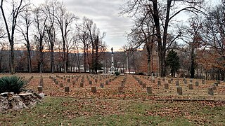
Camp Nelson Confederate Cemetery is a historic cemetery located near Cabot in northern Lonoke County, Arkansas and is near the site of a Confederate military camp Camp Hope, where 1,500 Confederate soldiers died during an epidemic during the fall of 1862. Camp Nelson Cemetery is located on Rye Drive, just off Cherry Road, just off Mt. Carmel Road in north Lonoke County about 2 miles east of Cabot.
Oakland Cemetery may refer to:
Princeton is a small unincorporated rural village in Princeton Township, Dallas County, Arkansas, United States, located at the junction of Arkansas highways 8 and 9, 7.5 miles (12.1 km) southwest of Carthage. Princeton Cemetery, which is listed on the National Register of Historic Places, is located in the community. It was first listed as a CDP in the 2020 census with a population of 13.
Fayetteville Confederate Cemetery is a cemetery for soldiers of the Confederate States located on the eastern side of Fayetteville in Washington County, Arkansas. Added to the National Register of Historic Places (NRHP) in 1993, the cemetery encompasses 3.5 acres (1.4 ha).

The Antioch Missionary Baptist Church Cemetery is located at 500 North McKinney Road in Sherrill, Arkansas, behind the Antioch Missionary Baptist Church. The earliest graves contain the remains of emancipated slaves, originally enslaved on the Good Hope Plantation in South Carolina, but moved to Jefferson County, Arkansas in 1860. Reverenced Lewis Mazique, a leader in the community, was the earliest documented burial, in 1885. The cemetery continues to be used today, although infrequently.

The Saline Cemetery is one of the older cemeteries in Drew County, Arkansas. It is located about 1.5 miles (2.4 km) west of Wilmar on Allis Road, near the ghost town of Allis. The Allis area was settled in 1860, and local residents established the Saline Associate Reform Presbyterian Church the following year, and the cemetery was established on the church grounds. The oldest inscribed grave dates to 1878, and is that of a member of the Davis family, early settlers whose descendants continue to maintain the cemetery. A number of the area's early settlers are among the more than 100 graves in the cemetery.
The Mound Cemetery is a historic cemetery, located just outside Arkansas City, Arkansas in Desha County. The oldest portion of the cemetery, dating to the 1860s, is located on top of a Mississippian culture mound, one of the few places the early American settlers of the area found to be safe from periodic flooding by the Mississippi River. It is located off County Road 351, about one-half mile outside Arkansas City, and about 3 miles (4.8 km) from the river.
The Harden Family Cemetery is a historic cemetery in rural Chicot County, Arkansas. It is located in a horse pasture off Hardin Road, north of the hamlet of Jennie, which is on Arkansas Highway 13 south of Lake Village.
Hampton Springs Cemetery is a cemetery in rural Dallas County, Arkansas, at the junction of county roads 425 and 427, near the city of Carthage. The cemetery is divided into two sections, one in which traditional European grave markers predominate, and another section in which graves are marked by a local adaptation of African burial customs.

Tulip Cemetery is a historic cemetery in Tulip, a small hamlet in rural Dallas County, Arkansas. It is located off Arkansas Highway 9, just behind the Tulip Methodist Church, occupying a high spot in the area. Tulip was one of the first settlements in Dallas County; the cemetery's oldest documented grave dates to 1847. It also includes the graves of six Confederate Army soldiers.

Mills Cemetery is a small historic cemetery in rural Little River County, Arkansas. It is a 3.5-acre (1.4 ha) parcel of land on the north side of County Road 40, about 1/8 mile west of its junction with United States Route 71, about 2 miles (3.2 km) north of Wilton, Arkansas. It is one of the oldest cemeteries in the county, holding the graves of members of the Mills family, who first explored the Little River County area in the 1850s. The oldest of the 39 known graves dates to the 1850s; one of the most prominent burials is Joel Mills (1808–71), who was a major plantation owner.
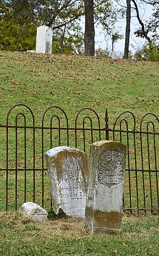
The Helena Confederate Cemetery is located in the southwest corner of the Maple Hill Cemetery on Holly Street in Helena, Arkansas. It is a small section of the larger cemetery, under one acre in size, and is marked by two significant memorials: the Confederate Memorial and the memorial to Confederate Army General Patrick Cleburne, whose burial here is the only known place associated with his life. The Cleburne memorial is a marble shaft 15 feet (4.6 m) in height, topped by an urn with flames coming from its top. The Confederate Memorial is a marble depiction of a soldier, mounted on a 30-foot (9.1 m) granite shaft, surrounded by pyramids of cannonballs and inverted cannons. The cemetery has more than 100 marked graves, 15 of which are unidentified Confederate dead, and 23 are of those killed in the 1863 Battle of Helena.

Bethel Cemetery is a cemetery in rural western Lawrence County, Arkansas. It is located off County Road 225, about 1.1 miles (1.8 km) north of Arkansas Highway 117, roughly midway between Black Rock and Smithville. Its oldest portion occupies a roughly triangular parcel of land, surrounded by a perimeter road, with a gate at the eastern corner. It is located next to the site of a church which was established in the 1820s, and its oldest grave is supposedly the 1835 burial of an American Revolutionary War veteran. The oldest dated grave marker is marked 1858, and the cemetery continues to be used today. The cemetery is a reminder of the community of Denton, which flourished in the mid-19th century, but declined after it was bypassed by the railroad.
The County Home Cemetery is a historic cemetery in Heritage Park, on Heritage Park Road in Piggott, Arkansas. The cemetery occupies about 1.1 acres (0.45 ha) in the center of the park, and is marked by a monument and bench. The park and cemetery are located on the former site of the Clay County poor house, built in 1911. The cemetery contains approximately sixty graves, many unmarked, of indigents who died at the home. The buildings of the facility were demolished in 1954, and the cemetery is the principal tangible reminder of its existence.

Buckville Cemetery is a historic cemetery in rural Garland County, Arkansas. It is one of the few surviving remnants of the town of Buckville, which was inundated by the creation of Lake Ouachita; the other is the nearby Buckville Baptist Church, which was moved to its present location above the lake's planned water level in 1951. The cemetery, located near the end of Buckville Road on the north side of the lake, the cemetery has more than 300 burials, include graves of some of the area's earliest settlers. The oldest documented burial is dated 1861.
Fredonia Cemetery, also known as Holly Grove Cemetery and Stevens Creek Cemetery, is a cemetery in rural White County, Arkansas, northwest of Bald Knob on Fredonia Road. The oldest portion of the cemetery houses marked graves with the oldest dating to 1870, and is estimated to contain at least 300 unmarked graves. The cemetery houses many of the area's early settlers.

The Vest Cemetery is a historic cemetery in rural western Izard County, Arkansas. It is located at the end of Vest Cemetery Road, north of the hamlet of Boswell, adjacent to the site of the former Vest family homestead. It is a rectangular parcel, with 72 known graves dating back to the early settlement period of Boswell in the 1870s. A portion of the cemetery is lined by a low rock wall, built to keep cattle from grazing on the family graves of the Cockersham family. The entire cemetery is now lined by woven wire fencing.

The McCraw Cemetery is a historic cemetery in Jacksonville, Arkansas. It is located in a wooded area on the city's southeastern outskirts, well south of the Military Road, and west of the Military Mobile Homes. It has 37 marked graves, of which ten are of children. The markers date from 1841 to 1937, and include some of the first settlers of northern Pulaski County. The cemetery, a family plot of the McCraw family, was lost for many years, and is now under the care of the Reed's Bridge Historical Society.

The Norristown Cemetery is a historic cemetery off Lock and Dam Road, on the south side of Russellville, Arkansas. It is a small community cemetery, with thirty marked grave sites, the oldest of which is dated 1853 and the newest 1934. It is the only surviving remnant of the community of Norristown, which was an early settlement and the first county seat of Pope County.
The Green Cemetery is a historic family cemetery in rural southwestern Ouachita County, Arkansas. It is on the west side of County Road 1, about 2 miles (3.2 km) northwest of Stephens. It is a small and somewhat overgrown plot, containing eighteen marked graves, all for members of the extended Green family, who were early settlers to the area. The oldest marked grave is dated 1853, and the last is dated 1909. The stone markers include works by James Reynolds and John Stroud, both of New Orleans.


