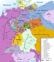
Westphalia is a region of northwestern Germany and one of the three historic parts of the state of North Rhine-Westphalia. It has an area of 20,210 square kilometres (7,800 sq mi) and 7.9 million inhabitants.

The Electoral Palatinate or the Palatinate, officially the Electorate of the Palatinate, was a constituent state of the Holy Roman Empire. The electorate had its origins under the rulership of the Counts Palatine of Lotharingia in 915; it was then restructured under the Counts Palatine of the Rhine in 1085. From 1214 until the Electoral Palatinate was merged into the Kingdom of Bavaria in 1805, the House of Wittelsbach provided the Counts Palatine or Electors. These counts palatine of the Rhine would serve as prince-electors from "time immemorial", and were noted as such in a papal letter of 1261; they were confirmed as electors by the Golden Bull of 1356.
Borken is a Kreis (district) in the northwestern part of North Rhine-Westphalia, Germany in the Münster region. Neighboring districts are Steinfurt, Coesfeld, Recklinghausen, Wesel, Cleves, Bentheim in the Lower Saxony and the Dutch provinces Gelderland and Overijssel. The two biggest cities are Bocholt and Gronau.

The Landgraviate of Hesse-Kassel, spelled Hesse-Cassel during its entire existence, also known as the Hessian Palatinate, was a state of the Holy Roman Empire. The state was created in 1567 when the Landgraviate of Hesse was divided upon the death of Philip I, Landgrave of Hesse. His eldest son William IV inherited the northern half of the Landgraviate and the capital of Kassel. The other sons received the Landgraviates of Hesse-Marburg, Hesse-Rheinfels and Hesse-Darmstadt.

Bocholt is a city in the north-west of North Rhine-Westphalia, Germany, part of the district Borken. It is situated 4 km south of the border with the Netherlands. Suderwick is part of Bocholt and is situated at the border annex to Dinxperlo.

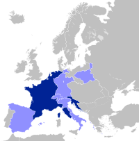
German mediatisation was the major redistribution and reshaping of territorial holdings that took place between 1802 and 1814 in Germany by means of the subsumption and secularisation of a large number of Imperial Estates, prefiguring, precipitating, and continuing after the dissolution of the Holy Roman Empire. Most ecclesiastical principalities, free imperial cities, secular principalities, and other minor self-ruling entities of the Holy Roman Empire lost their independent status and were absorbed by the remaining states. By the end of the mediatisation process, the number of German states had been reduced from almost 300 to just 39.
Salm-Reifferscheid-Dyck was a small imperial county of the Holy Roman Empire. Its territory was the area around Dyck in present North Rhine-Westphalia, Germany.

Salm is the name of several historic countships and principalities in present Germany, Belgium, Luxembourg and France.
Salm-Kyrburg was a state of the Holy Roman Empire located in present-day Rhineland-Palatinate, Germany, one of the various partitions of Salm. It was twice created: the first time as a Wild- and Rhinegraviate, and secondly as a Principality. The first state of Salm-Kyrburg was partitioned between itself, Salm-Mörchingen and Salm-Tronecken in 1607, and was inherited by Salm-Neuweiler in 1681 upon the lines' extinction.
The Principality of Salm-Salm was a state of the Holy Roman Empire. It was located in the present-day French departments of Bas-Rhin and Vosges; it was one of a number of partitions of Salm.
Salm-Reifferscheid-Krautheim was a short-lived Imperial Estate to the Holy Roman Empire, which was created as a succession of Salm-Reifferscheid-Bedburg in 1803. It was raised to a Principality in 1804, and was mediatised to the Kingdom of Wurttemberg and the Grand Duchy of Baden in 1806.

The Electorate of Hanover was an electorate of the Holy Roman Empire, located in northwestern Germany and taking its name from the capital city of Hanover. It was formally known as the Electorate of Brunswick-Lüneburg. For most of its existence, the electorate was ruled in personal union with Great Britain and Ireland following the Hanoverian Succession.

The Duchy of Westphalia was a historic territory in the Holy Roman Empire, which existed from 1102 to 1803. It was located in the greater region of Westphalia, originally one of the three main regions in the German stem duchy of Saxony and today part of the state of North Rhine-Westphalia. The duchy was held by the archbishop-electors of Cologne until its secularization in 1803.

Amalie Zephyrine of Salm-Kyrburg, was a German noblewoman by birth member of the House of Salm in the Salm-Kyrburg branch and through her marriage she was Princess of Hohenzollern-Sigmaringen.
Frederick IV, Prince of Salm-Kyrburg was the prince of Salm-Kyrburg, Ahaus and Bocholt from 1794 to 1813. He was the son and successor of Frederick III and his wife, Princess Johanna Franziska of Hohenzollern-Sigmaringen. He initially had two elder brothers and one younger sister, but all three of these died young.

The Prince-Bishopric of Lübeck, was an ecclesiastical principality of the Holy Roman Empire until 1803. Originally ruled by Roman-Catholic bishops, after 1586 it was ruled by lay administrators and bishops who were members of the Protestant Holstein-Gottorp line of the House of Oldenburg. The prince-bishops had seat and vote on the Ecclesiastical Bench of the College of Ruling Princes of the Imperial Diet.

The flag of the German State of North Rhine-Westphalia is a horizontal tricolor consisting of green, white and red.
The Lordship of Anholt was a small state of the Holy Roman Empire. It was an imperial estate and a member of the Lower Rhenish-Westphalian Circle.

The House of Salm was an ancient Lotharingian noble family originating from Salmchâteau in the Ardennes and ruling Salm. The dynasty is above all known for the experiences of the Upper Salm branch which came to be located at Château de Salm in the Vosges mountain range and over time came to rule over a principality whose capital was Badonviller then Senones.
The German Emperors after 1873 had a variety of titles and coats of arms, which in various compositions became the officially used titles and coats of arms. The title and coat of arms were last fixed in 1873, but the titles did not necessarily mean that the area was really dominated, and sometimes even several princes bore the same title.