Project Mausam

Last updated

Project Mausam
Project Mausam
Indian-Flag.png
Type of projectCultural and economic
CountryIndia
MinistryMinistry of Culture
Key peopleCulture Secretary Ravindra Singh
LaunchedApril 2014
38th session of the World Heritage Committee
Website https://indiaculture.nic.in/project-mausam

Project Mausam is a cultural project by the Indian Ministry of Culture and Archaeological Survey of India (ASI) with the Indira Gandhi National Centre for the Arts and the National Museum in New Delhi which aims to connect countries on the Indian Ocean. The term "mausam" means "weather" or "season" and is derived from regional dialects including the Arabic word mawsim, which refers to the season when boats can safely sail. [1] [2]

Contents

Project Mausam aims to rebuild maritime cultural connections with the 39 countries bordering the Indian Ocean. The project also aims to bring together historical and archaeological researchers to record the diversity of economic, cultural, and religious interactions between countries in. There are two visions for Project Mausam: the first is to understand national cultures between countries and the second is to rebuild communications between countries. [3]

The Indian Ocean, as depicted in the CIA World Factbook (1990) World Factbook (1990) Indian Ocean.jpg
The Indian Ocean, as depicted in the CIA World Factbook (1990)

Objectives

The project has four main objectives to complete its vision. First, it aims to revive lost connections with countries. The nations in the Indian Ocean have been interconnected for many centuries. The project seeks to document and celebrate the common economic ties and cultural values of countries in the Indian Ocean world, beyond contemporary ethic[ clarification needed ] and national boundaries, to strengthen the connections between countries in the Indian Ocean sphere and to set a precedent for future cooperation. [4]

Second, it plans to create connections and relationships to the existing World Heritage sites. The project would provide a platform to link the sites of cultural and natural World Heritage in the Indian Ocean world through a cross-national and cross-cultural narrative. [4] Third, the project wishes to redefine cultural landscapes by identifying gaps in World Heritage sites and filling them through creating relationships between existing sites of cultural and natural heritage. It will also provide a multilayered and holistic perspective, which will allow for a fresh strategy to help understand past and contemporary relationships. [4]

Finally, it aims to achieve cross-national World Heritage nomination. The project would advocate for maritime routes of the Indian Ocean to achieve cross-national nomination with sustainable tourism, heritage development, research, visibility, and promotion of cultural conventions. [4]

Initially, the idea of Project Mausam was proposed by Ravindra Singh, then-secretary of the Ministry. Afterwards, the government of India was preparing to nominate the project as a transnational inscription on the UNESCO World Heritage List. The Indian government has increased financial investments to explore potential benefits for future generations.

Historical background

Geographically, the Indian Ocean is bounded by the Antarctic or Southern Ocean in the south and forms a confluence with the Bay of Bengal and the Arabian Sea in the north. The ocean is bordered by Africa in the west and by Asia in the northeast, surrounding India and Sri Lanka. Naval trade on the Indian Ocean dates back to the third millennium BCE, when residents of the Indus Valley opened maritime trading with Mesopotamia, Egypt, East Africa, and the Roman Empire. Through these maritime trade networks, many goods were exchanged, including medicine, aromatics, spices, dyes, wood, grain, gems, textiles, metals, livestock, and stones. Those goods were then sold along the coastline of the Indian Ocean. The trade facilitated the exchange of religions, cultures, and technologies, contributing to the expansion of Buddhism, Christianity and Hinduism. [4]

There was an increase in trade between India and Rome after the Roman annexation of Egypt. According to the Greek historian Strabo, 120 boats left the port of Myos Hormos annually for India when Aelius Gallus was prefect of Egypt.[ citation needed ] Indian states controlled the ocean until the thirteenth century without the influence of foreign powers. However, after the thirteenth century, the economic structure of India had changed due to the control of the sea by foreign powers. For instance, the Indian economy became dependent on foreign businesses after European powers took control of Indian Ocean sea routes. The ocean was controlled by the British Empire until World War I, during which Germany took over the sea. The Japanese subsequently gained maritime supremacy in World War II. [5] Currently, the Indian Ocean carries half of the container ships, a third of the cargo, and two-thirds of the oil tankers in the world. [6]

Achievement and development

During 2014, there was a publication called "Maritime Cultural Landscapes Across the Indian Ocean" by Himanshu Prabha Ray.[ further explanation needed ] Nineteen lectures about Project Mausam were held on a range of themes in the same year. There was also an exhibition called "Africans in India: A Rediscovery" in the IGNCA held in India, October to November 2014 with a one day[ when? ] conference. [7] A national conference about maritime trade routes was organised by Kerala Tourism and ASI in Kochi.

There was an exhibition called "Unearthing Pattanam: Histories, Cultures, and Crossings" in the Indian National Museum in 2014. [7] The archaeological Pattanam site is located about 25 kilometres north of Kochi in Kerala. The site is about four kilometres from the coast and sits in the Periyar River delta. The location of Pattanam and the archaeological evidence unearthed in the site indicate the possibility that Pattanam could have been an integral part of the port of Muziris or Muciri Pattinam, which are mentioned in Tamil Sangam and Greco-Roman literature. [8]

In 2016, ASI and IGNCA held an international conference about maritime routes on 16 February in Mumbai. During the same year, the director of World Heritage came to several Asian countries to explore the potential of Project Mausam.[ citation needed ]

On 28 January 2017, there was a conference discussing Indian maritime culture and its potential. On 22 March 2018, a conference about traditions of Indian maritime was held in Kerala, which lasted two days. Finally, there was a 150 million rupees fund allocation approved by the SFC for the development of Project Mausam from 2015 to 2017, of which 4 million rupees had been used. A fund of 60 million rupees has been approved to extend the project through 2020. [7] The project has seen mixed and limited success depending on how the project is defined and what it hoped to achieve. [9]

Indian Missions in the 39 countries have approached local authorities and several countries including the following, have nominated their resource persons for the Project Mausam: Bangladesh, Cambodia, Saudi Arabia, Thailand, Indonesia, Oman, Qatar, Singapore, Malaysia, The Islamic republic of Iran, UAE, Myanmar, Philippines and Jordan [10]

Commentary

Project Mausam is India's answer to the Maritime Silk Road of China, according to Akhilesh Pillalamarri, who wrote that "China is developing MSR in the backyard of India with strong support from Sri Lanka and the Maldives. India is planning to join the MSR for its potential economic benefits in the future." [11]

As reported in The New Indian Express , the Indian government has been trying to move for UNESCO to award transnational heritage status to Project Mausam while China has been countering on the argument that it will be detrimental to the revival of the Maritime Silk Road. [12]

An article in Economic and Political Weekly by KM Seethi argued that due to the increasing significance and influence of China, especially in building new maritime connect with Indian Ocean countries, India launched Project Mausam to balance the increasing status of China in the Indian Ocean world and revive historical ties in a new sustainable cross-cultural connection with other countries. [13]

C. Mallapur wrote that the "Indian Ocean region has attracted attention from the world due to its strategic location and lanes for naval trade. As being the two largest countries in Asia, China and India are trying to build and enhance connections between countries in which trade is a significant factor." Project Mausam indicates that the Indian government is strategically using its soft power. The government will have to take strong measures to effectively implement the project by minimising overlapping governing bodies with a single dominating agency. Once the project is implemented, it will provide more opportunities for India's economy and trade as well as build international contact, in accordance with the "Look East" and "Link West" policies. [6]

Related Research Articles

<span class="mw-page-title-main">Southeast Asia</span> Subregion of the Asian continent

Southeast Asia is the geographical south-eastern region of Asia, consisting of the regions that are situated south of China, east of the Indian subcontinent, and north-west of mainland Australia which is part of Oceania. Southeast Asia is bordered to the north by East Asia, to the west by South Asia and the Bay of Bengal, to the east by Oceania and the Pacific Ocean, and to the south by Australia and the Indian Ocean. Apart from the British Indian Ocean Territory and two out of 26 atolls of Maldives in South Asia, Maritime Southeast Asia is the only other subregion of Asia that lies partly within the Southern Hemisphere. Mainland Southeast Asia is entirely in the Northern Hemisphere. East Timor and the southern portion of Indonesia are the parts of Southeast Asia that lie south of the Equator.

<span class="mw-page-title-main">History of Southeast Asia</span>

The history of Southeast Asia covers the people of Southeast Asia from prehistory to the present in two distinct sub-regions: Mainland Southeast Asia and Maritime Southeast Asia. Mainland Southeast Asia comprises Cambodia, Laos, Myanmar, Peninsular Malaysia, Thailand and Vietnam whereas Maritime Southeast Asia comprises Brunei, Cocos (Keeling) Islands, Christmas Island, East Malaysia, East Timor, Indonesia, Philippines and Singapore.

<span class="mw-page-title-main">Silk Road</span> Ancient network of trade routes connecting Asia to Europe

The Silk Road was a network of Eurasian trade routes active from the second century BCE until the mid-15th century. Spanning over 6,400 kilometers, it played a central role in facilitating economic, cultural, political, and religious interactions between the East and West. The name "Silk Road", first coined in the late 19th century, has fallen into disuse among some modern historians in favor of Silk Routes, on the grounds that it more accurately describes the intricate web of land and sea routes connecting Central, East, South, Southeast, and West Asia as well as East Africa and Southern Europe.

<span class="mw-page-title-main">Trade route</span> Series of roads, pathways and stoppages for commercial trade on land; excludes rail

A trade route is a logistical network identified as a series of pathways and stoppages used for the commercial transport of cargo. The term can also be used to refer to trade over bodies of water. Allowing goods to reach distant markets, a single trade route contains long-distance arteries, which may further be connected to smaller networks of commercial and noncommercial transportation routes. Among notable trade routes was the Amber Road, which served as a dependable network for long-distance trade. Maritime trade along the Spice Route became prominent during the Middle Ages, when nations resorted to military means for control of this influential route. During the Middle Ages, organizations such as the Hanseatic League, aimed at protecting interests of the merchants and trade became increasingly prominent.

<span class="mw-page-title-main">Maritime Southeast Asia</span> Cultural and economic area within Southeast Asia

Maritime Southeast Asia comprises the countries of Brunei, Indonesia, Malaysia, the Philippines, Singapore, and East Timor.

<span class="mw-page-title-main">Kodungallur</span> Municipality in Kerala, India

Kodungallur is a historically significant town situated on the banks of river Periyar on the Malabar Coast in Thrissur district of Kerala, India. It is 29 kilometres (18 mi) north of Kochi (Cochin) by National Highway 66 and 38 km (24 mi) from Thrissur. Kodungallur, being a port city at the northern end of the Kerala lagoons, was a strategic entry point for the naval fleets to the extensive Kerala backwaters. It was here that one of Jesus's disciples, St. Thomas reached during 1st century AD to preach Christianity.

<span class="mw-page-title-main">Indian Ocean Rim Association</span> International organization

The Indian Ocean Rim Association (IORA), formerly known as the Indian Ocean Rim Initiative (IORI) and the Indian Ocean Rim Association for Regional Cooperation (IOR-ARC), is an international organisation consisting of 23 states bordering the Indian Ocean. The IORA is a regional forum, tripartite in nature, bringing together representatives of Government, Business and Academia, for promoting co-operation and closer interaction among them. It is based on the principles of for strengthening Economic Cooperation particularly on Trade Facilitation and Investment, Promotion as well as Social Development of the region. The Coordinating Secretariat of IORA is located at Ebene, Mauritius.

<span class="mw-page-title-main">Indian maritime history</span> Aspect of Indian history

Indian maritime history begins during the 3rd millennium BCE when inhabitants of the Indus Valley initiated maritime trading contact with Mesopotamia. As per Vedic records, Indian traders and merchants traded with the far east and Arabia. During the Maurya Empire, there was a definite "naval department" to supervise the ships and trade. At the end of 1st century BCE Indian products reached the Romans during the rule of Augustus, and the Roman historian Strabo mentions an increase in Roman trade with India following the Roman annexation of Egypt. As trade between India and the Greco-Roman world increased, spices became the main import from India to the Western world, bypassing silk and other commodities. Indians were present in Alexandria while Christian and Jewish settlers from Rome continued to live in India long after the fall of the Roman Empire, which resulted in Rome's loss of the Red Sea ports, previously used to secure trade with India by the Greco-Roman world since the Ptolemaic dynasty. The Indian commercial connection with Southeast Asia proved vital to the merchants of Arabia and Persia during the 7th–8th century. A study published in 2013 found that some 11 percent of Australian Aboriginal DNA is of Indian origin and suggests these immigrants arrived about 4,000 years ago, possibly at the same time dingoes first arrived in Australia.

<span class="mw-page-title-main">Muziris</span> Historical settlement and harbour on the Malabar Coast

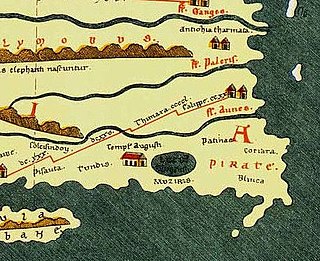
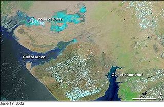
Muchiri, commonly anglicized as Muziris was an ancient harbour and an urban centre on the Malabar Coast. Muziris found mention in the Periplus of the Erythraean Sea, the bardic Tamil poems and a number of classical sources. It was the major ancient port city of Cheras. Core of the city situated in the present day North Paravoor area. The exact location of Muziris has been a matter of dispute among historians and archaeologists. However, excavations since 2004 at Pattanam, near North Paravur, have led some experts to suggesting the hypothesis that the city was located just there. It was an important trading port for Christian and Muslim merchants arriving from other countries.

Indians in the United Arab Emirates constitute the largest part of the population of the country. Over 3,860,000 Indian expats are estimated to be living in the UAE, which is over 38 percent of the total population of the UAE and the fourth highest number of overseas Indian people in the world, after the United States, Saudi Arabia and Nepal. Indian contact with the emirates that now constitute the UAE dates back several centuries, as a result of trade and commerce between the emirates and India. The UAE has experienced a tremendous increase in the population of resident Indians who initially migrated to the country as a result of opportunities in petroleum. Now, Indians are key to the UAE's construction, retail, financial services, healthcare, manufacturing and transport sectors. A sizeable minority of Indian migrants are involved in professional services and entrepreneurship. Relations between India and the UAE have traditionally been very friendly.

<span class="mw-page-title-main">India–Myanmar relations</span> Bilateral relations

India–Myanmar relations, also knows as Indian–Burmese relations or Indian–Myanmar relations, are the bilateral relations between the Republic of India and the Republic of the Union of Myanmar. These relations encompass the political, economic and socio-cultural relations that exist between the two neighboring Asian countries. Political relations have improved considerably since 1993, overcoming tensions related to drug trafficking, the suppression of democracy and the rule of the military junta in Myanmar. Political leaders from both countries meet regularly on a bilateral basis and within the ASEAN Plus Six community. Economic relations are considerable with India representing Myanmar's 4th largest export market and the country's 5th largest import partner.

<span class="mw-page-title-main">India–Maldives relations</span> Bilateral relations

India and Maldives are neighbours sharing a maritime border. Relations have been friendly and close in strategic, economic and military cooperation. India continues to contribute to maintaining security as well as providing financial aid on the island nation.

The String of Pearls is a geopolitical hypothesis proposed by United States political researchers in 2004. The term refers to the network of Chinese military and commercial facilities and relationships along its sea lines of communication, which extend from the Chinese mainland to Port Sudan in the Horn of Africa. The sea lines run through several major maritime choke points such as the Strait of Mandeb, the Strait of Malacca, the Strait of Hormuz, and the Lombok Strait as well as other strategic maritime centres in Somalia and the littoral South Asian countries of Pakistan, Sri Lanka, Bangladesh, and the Maldives.

Africa–India relations are the historical, political, economic, and cultural connections between India and the African continent.

Indian Ocean trade has been a key factor in East–West exchanges throughout history. Long-distance trade in dhows and proas made it a dynamic zone of interaction between peoples, cultures, and civilizations stretching from Southeast Asia to East and Southeast Africa and East Mediterranean in the West in prehistoric and early historic periods. Cities and states on the Indian Ocean rim focused on both the sea and the land.

<span class="mw-page-title-main">China–Maldives relations</span> Bilateral relations

Diplomatic relations between the People's Republic of China and the Maldives were established in 1972. China has an embassy in Malé which opened in November 2011, and the Maldives has an embassy in Beijing which opened in 2009. Approximately 70 percent of the Maldives' total debt is attributed to Chinese projects, with an annual payment of $92 million to China, constituting around 10 percent of the country's entire budget. China has become pervasive in the Maldives, exerting influence over infrastructure, trade, and energy sectors, raising concerns of a new form of Chinese entrapment.

The foreign policy of the Modi government is associated with the policy initiatives made towards other states by the current government of India after Narendra Modi assumed the office of prime minister on May 26, 2014.

<span class="mw-page-title-main">21st Century Maritime Silk Road</span> Sea route part

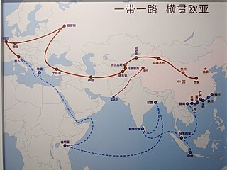
The 21st Century Maritime Silk Road, commonly just Maritime Silk Road (MSR), is the sea route part of the Belt and Road Initiative which is a Chinese strategic initiative to increase investment and foster collaboration across the historic Silk Road.

<span class="mw-page-title-main">Belt and Road Initiative</span> Chinas global infrastructure project

The Belt and Road Initiative, known within China as the One Belt One Road or OBOR/1B1R for short, sometimes referred to as the New Silk Road, is a global infrastructure development strategy adopted by the Chinese government in 2013 to invest in more than 150 countries and international organizations. It is considered a centerpiece of the Chinese leader Xi Jinping's foreign policy. The BRI forms a central component of Xi's "Major Country Diplomacy" strategy, which calls for China to assume a greater leadership role for global affairs in accordance with its rising power and status. It has been compared to the American Marshall Plan. As of August 2023, 155 countries were listed as having signed up to the BRI. The participating countries include almost 75% of the world's population and account for more than half of the world's GDP.

<span class="mw-page-title-main">Maritime Silk Road</span> Ancient and medieval maritime trade route

The Maritime Silk Road or Maritime Silk Route is the maritime section of the historic Silk Road that connected China, Southeast Asia, the Indian subcontinent, the Arabian peninsula, Somalia, Egypt and Europe. It began by the 2nd century BCE and flourished later on until the 15th century CE. Major players in the Maritime Silk Road include the merchants from the Tang, Song, Yuan and Ming dynasties of imperial China, Austronesian sailors in Southeast Asia, Tamil merchants in India and Southeast Asia, and Persian and Arab traders in the Arabian Sea and beyond. The network followed the footsteps of older maritime networks in Southeast Asia, as well as the maritime spice networks of Southeast Asia, Sri Lanka, India, and the Indian Ocean, coinciding with these ancient maritime trade roads by the current era.

References

  1. "Project Mausam". Ministry of Culture, Government of India. Retrieved 13 May 2019.
  2. Daniel, Thomas (2015). "Project Mausam: India's Grand Maritime Strategy (Part I)". Institute of Strategic and International Studies: 1–5.
  3. Shankar, Kumar. "People-Politics-Policy-Performance-Maritime Diplomacy: Whispers of an Indian Wind". login.ezproxy1.library.usyd.edu.au. Retrieved 13 May 2019.
  4. 1 2 3 4 5 cholan (25 June 2014). "Project 'Mausam • IAS Preparation Online". IAS Preparation Online. Retrieved 31 May 2019.
  5. Pearson, Michael N. "The Indian Ocean". login.ezproxy1.library.usyd.edu.au. Retrieved 13 May 2019.
  6. 1 2 Mallapur, Chaitanya (28 April 2017). "Mapping India's Lost Roots: Project Mausam and the Spice Route". China India Dialogue. Archived from the original on 15 August 2019. Retrieved 19 May 2019.
  7. 1 2 3 "Project 'Mausam' extended up to 2020 with the pre-approved fund of Rs 60,039,297: Dr. Mahesh Sharma". Press Information Bureau, Government of India. Retrieved 1 February 2022.
  8. "Unearthing Pattanam". Sahapedia. Retrieved 4 June 2019.
  9. Bhalla, Madhu (20 July 2020). "India Should Revive the Mausam Initiative – But Not as it Stands Now". The Wire. Retrieved 1 February 2022.
  10. "Progress of Project Mausam".
  11. Pillalamarri, Akhilesh (18 September 2014). "Project Mausam: India's Answer to China's 'Maritime Silk Road'". The Diplomat. Retrieved 13 May 2019.
  12. Sharma, Ritu (8 January 2017). "Project Mausam hits a Chinese wall". The New Indian Express. Retrieved 13 May 2019.
  13. Seethi, K M (5 June 2015). "A 2014 Project to Revive India's Historical 'Spice Route' Remains a non-starter". Economic and Political Weekly: 7–8.

Further reading