Proudman Oceanographic Laboratory

Last updated

A former home of POL, built at Bidston, west of Liverpool, in 1975 and used until around 2004. Demolished 2013. Proudman Oceanographic Laboratory, Bidston Hill - geograph.org.uk - 335675.jpg
A former home of POL, built at Bidston, west of Liverpool, in 1975 and used until around 2004. Demolished 2013.

The former Proudman Oceanographic Laboratory (POL) is based in Brownlow Street, Liverpool, England. In April 2010, POL merged with the National Oceanography Centre, Southampton (NOCS) to form the National Oceanography Centre. The Liverpool laboratory's scientific research focuses on oceanography encompassing global sea-levels and geodesy, numerical modelling of continental shelf seas and coastal sediment processes. This research alongside activities of surveying, monitoring, data management and forecasting provides strategic support for the wider mission of the Natural Environment Research Council.

Contents

A leading world centre in tidal prediction (with related interests in earth tides and storm surges) and a leading European centre in modelling and forecasting shelf sea dynamics, it is home to the Coastal Observatory in Liverpool Bay, the National Tidal and Sea Level Facility, the Permanent Service for Mean Sea Level and the British Oceanographic Data Centre. [1] [2] [3] [4]

History of tidal measurements

The history of tidal measurements taken at Liverpool starts with Jeremiah Horrocks (1619–1641) who was born and died at Toxteth. While he is most famous for predicting, and then observing, the transit of Venus in 1639 at Much Hoole near Preston, he also had a great interest in understanding ocean tides, and in particular in verifying that tidal changes were closely related to variations in the Moon's orbit. Shortly before his death, he is known to have made measurements of high waters (probably the times and perhaps also the heights of high tide) on the Mersey coast near his home for at least a month. Unfortunately, his tidal measurements (but not his astronomical records) were lost in the civil war or possibly in the Fire of London.[ citation needed ]

William Hutchinson (1716–1801) compiled the first extended set of sea level measurements in the UK, together with a comprehensive set of meteorological information. He established the Bidston Lighthouse in 1771. His measurements of the heights and times of every high water during 1764–1793 at the Liverpool Old Dock were of high quality and are still being used in scientific research today. Hutchinson's measurements of the tides during 1764–1767 were used by Richard and George Holden to derive the first reliable publicly accessible tide tables in the UK, first published in 1770 for over 200 years.[ citation needed ]

To mark Liverpool 2007 and 2008, POL together with colleagues at Brock University, Canada will produce a CD containing copies of all Hutchinson's tidal and meteorological data sets and background information on his life.

19th century

During the 19th century, the Mersey Docks and Harbour Board (MDHB) established a network of a dozen state-of-the-art sea level stations along the River Mersey, Dee and neighbouring coasts. They were used to provide the best possible tidal information to what became one of the most important ports in the British Empire, together with data for surveying and coastal engineering. The main Liverpool gauges were at George’s Pier, the present-day Pier Head, then Prince's Pier next to the ocean liner landing stage and now Gladstone Dock. Together these sites have provided data which make up the longest UK sea level record and one of the longest in the world. These data have been used to study long term changes in mean sea levels and in the sea level extreme levels which often result in flooding.

In 1845, the MDHB established the Liverpool Observatory at Waterloo Dock, Liverpool to provide all the tidal, meteorological and astronomical information required by ship owners.

In 1866, the expanding port resulted in the Observatory being relocated in 1866 to Bidston Hill on the Wirral, where Hutchinson had established Bidston Lighthouse in 1771. It was built with sandstone from excavating the deep cellars. [5]

20th century

In 1929, the Liverpool Observatory was merged with the Liverpool University Tidal Institute and its work became more focused on scientific research, rather than port operations. This combined institute (with a number of name changes and official owners) was to become a world-famous centre for sea level and tidal research with three Fellows of the Royal Society among its Directors: Joseph Proudman, Arthur Doodson and David Cartwright.

The Institute concentrated on sea level monitoring and prediction around UK coasts, and indeed on understanding sea level changes worldwide: In 1933, the Permanent Service for Mean Sea Level was established at Bidston by Proudman and remains important. Such understanding informs government departments on policies for coastal protection, and contributes to international scientific study groups such as those of the Intergovernmental Panel on Climate Change. The tide can be predicted at any location around the UK with several centimetre accuracy. Superimposed upon the astronomical tide, which is caused by the gravitational attraction of the Moon and Sun, is the storm surge caused by strong winds and low air pressures. [ citation needed ]

In 1953, the major flood at Sea Palling and other parts of the north Norfolk Coast resulted from a large storm surge occurring at high tide. This disaster led to the development of the UK National Tide Gauge Network and the UK Storm Tide Forecasting System. The Institute led the development of computer models to predict UK storm surges several days ahead based on forecast weather information. Routine surge forecasts are now produced by the Met Office and result in flood warnings issued by the Environment Agency.[ citation needed ]

In 1965, the Liverpool Tidal Institute became part of the Natural Environment Research Council. In 1970 it fused with the National Institute of Oceanography to form the Institute of Oceanographic Sciences. [6]

In 1979, a new building right next to the Observatory for staff and a computer mainframe was opened and named after Joseph Proudman; in 2004 it relocated to a new building at the University of Liverpool and the Proudman building on Bidston Hill was torn down in 2012. [5] In 1987, the Liverpool Tidal Institute was renamed the Proudman Oceanographic Laboratory.[ citation needed ]

21st century

In 2004, it moved from Bidston to the campus of Liverpool University with sea level science, shelf sea science and numerical modelling of ocean processes as the three main areas of expertise of research.

Coastal Observatory

POL houses the Coastal Observatory in Liverpool Bay. Its objective is to study a typical coastal sea's response both to natural forces and to the effects of human activity. The Observatory integrates real-time data measurements with data from models into a "pre-operational coastal prediction system" [7] [ dead link ] whose results will be displayed on the web. The concept is founded on obtaining data in real time, using telemetry, sending the data from underwater to the sea surface, to land, to POL's web site, enabling what is often known as 'armchair oceanography'.

Measurements

The aim of the Coastal Observatory is to build a time series of data. The Observatory has a particular interest in such areas as storm surges, seasonality, and variations in river discharge, with an emphasis on the River Mersey. August 2007 marked five years of continuous running of the Coastal Observatory in Liverpool Bay, taking measurements such as:

See also

Related Research Articles

<span class="mw-page-title-main">Tide</span> Rise and fall of the sea level under astronomical gravitational influences

Tides are the rise and fall of sea levels caused by the combined effects of the gravitational forces exerted by the Moon and are also caused by the Earth and Moon orbiting one another.

<span class="mw-page-title-main">Oceanography</span> Study of physical, chemical, and biological processes in the ocean

Oceanography, also known as oceanology, sea science and ocean science, is the scientific study of the oceans. It is an Earth science, which covers a wide range of topics, including ecosystem dynamics; ocean currents, waves, and geophysical fluid dynamics; plate tectonics and seabed geology; and fluxes of various chemical substances and physical properties within the ocean and across its boundaries. These diverse topics reflect multiple disciplines that oceanographers utilize to glean further knowledge of the world ocean, including astronomy, biology, chemistry, geography, geology, hydrology, meteorology and physics. Paleoceanography studies the history of the oceans in the geologic past. An oceanographer is a person who studies many matters concerned with oceans, including marine geology, physics, chemistry, and biology.

<span class="mw-page-title-main">Storm surge</span> Rise of water associated with a low-pressure weather system

A storm surge, storm flood, tidal surge, or storm tide is a coastal flood or tsunami-like phenomenon of rising water commonly associated with low-pressure weather systems, such as cyclones. It is measured as the rise in water level above the normal tidal level, and does not include waves.

<span class="mw-page-title-main">Bidston</span> Village in Wirral, Merseyside, England

Bidston is a village and civil parish in the Metropolitan Borough of Wirral in Merseyside, England.

<span class="mw-page-title-main">Waterloo Dock, Liverpool</span>

Waterloo Dock is a dock on the River Mersey, England, and part of the Port of Liverpool. It is situated in the northern dock system in Vauxhall and connected to Princes Half Tide Dock to the south. The site of Victoria Dock is located to the north.

Joseph Proudman, CBE, FRS was a distinguished British mathematician and oceanographer of international repute. His theoretical studies into the oceanic tides not only "solved practically all the remaining tidal problems which are soluble within the framework of classical hydrodynamics and analytical mathematics" but laid the basis of a tidal prediction service developed with Arthur Doodson of great international importance.

This is a list of meteorology topics. The terms relate to meteorology, the interdisciplinary scientific study of the atmosphere that focuses on weather processes and forecasting.
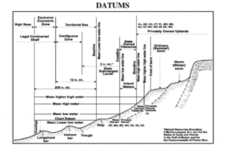
<span class="mw-page-title-main">Chart datum</span> Level of water from which depths displayed on a nautical chart are measured

A chart datum is the water level surface serving as origin of depths displayed on a nautical chart and for reporting and predicting tide heights. A chart datum is generally derived from some tidal phase, in which case it is also known as a tidal datum. Common chart datums are lowest astronomical tide (LAT) and mean lower low water (MLLW). In non-tidal areas, e.g. the Baltic Sea, mean sea level (MSL) is used. A chart datum is a type of vertical datum and must not be confused with the horizontal datum for the chart.

The National Oceanography Centre (NOC) is a marine science research and technology institution based on two sites in Southampton and Liverpool, England. It is the UK’s largest institution for integrated sea level science, coastal and deep ocean research and technology development. The Centre was established to promote cooperation with institutions across the UK marine science community, to better address key issues including sea level change, the ocean's role is climate change, computer simulation of the ocean's behaviour, and the long term monitoring and future of the Arctic Circle.

<span class="mw-page-title-main">Bidston Hill</span> Hill and woodland in Bidston, Wirral, England

Bidston Hill is 100 acres (0.40 km2) of heathland and woodland containing historic buildings and ancient rock carvings, on the Wirral Peninsula, near the Birkenhead suburb of Bidston, in Merseyside, England. With a peak of 231 feet (70 m), Bidston Hill is one of the highest points on the Wirral. The land was part of Sir Robert Vyner's estate and purchased by Birkenhead Corporation in 1894 for use by the public.

Arthur Thomas Doodson was a British oceanographer.

The North West Shelf Operational Oceanographic System (NOOS) monitors physical, sedimentological and ecological variables for the North Sea area. NOOS is operated by partners from the nine countries bordering the extended North Sea and European North West Shelf; Belgium, Denmark, France, Germany, Ireland, Netherlands, Norway, Sweden, and United Kingdom. Working collaboratively to develop and implement ocean observing systems in the area. Near real time and recent history sea levels are available to on their web site in map, graph or table format.

Indian National Center for Ocean Information Services (INCOIS) is an autonomous organization of the Government of India, under the Ministry of Earth Sciences, located in Pragathi Nagar, Hyderabad. ESSO-INCOIS was established as an autonomous body in 1998 under the Ministry of Earth Sciences (MoES) and is a unit of the Earth System Science Organization (ESSO). ESSO- INCOIS is mandated to provide the best possible ocean information and advisory services to society, industry, government agencies and the scientific community through sustained ocean observations and constant improvements through systematic and focussed research.

<span class="mw-page-title-main">Outline of oceanography</span> Hierarchical outline list of articles related to oceanography

The following outline is provided as an overview of and introduction to Oceanography.

<span class="mw-page-title-main">British Oceanographic Data Centre</span> National facility for conserving and distributing data about the marine environment

The British Oceanographic Data Centre (BODC) is a national facility for looking after and distributing data about the marine environment. BODC is the designated marine science data centre for the United Kingdom and part of the National Oceanography Centre (NOC) — primarily at its facility in Liverpool, with small number of its staff in Southampton. The centre provides a resource for science, education and industry, as well as the general public.

<span class="mw-page-title-main">Tuvalu Meteorological Service</span>

The Tuvalu Meteorological Service (TMS) is the principal meteorological observatory of Tuvalu and is responsible for providing weather services to the islands of Tuvalu. A meteorological office was established on Funafuti at the time the islands of Tuvalu were administered as parts of the Gilbert and Ellice Islands colony of the United Kingdom. The meteorological office is now an agency of the government of Tuvalu.

<span class="mw-page-title-main">Metocean</span> The syllabic abbreviation of meteorology and (physical) oceanography.

In offshore and coastal engineering, metocean refers to the syllabic abbreviation of meteorology and (physical) oceanography.

<span class="mw-page-title-main">Ishiguro Storm Surge Computer</span>

The Ishiguro Storm Surge Machine is an analogue computer built by Japanese oceanographer Shizuo Ishiguro. Between 1960 and 1983, it was used to model storm surges in the North Sea by the UK National Institute of Oceanography. It is now on display in the Mathematics Gallery of the Science Museum in London.
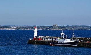
<span class="mw-page-title-main">Newlyn Tidal Observatory</span> British tidal observatory

Newlyn Tidal Observatory is a grade II listed tide gauge hut on the South Pier in Newlyn, Cornwall in England. Measurements of sea level taken at the observatory between 1915 and 1921 were used to define the reference level, Ordnance Datum Newlyn, for height measurement on the British mainland. The tide gauge has collected over 100 years of observations which has significantly contributed to studies in sea level science.

David Pugh was a British marine scientist and academic. He founded the Global Sea Level Observing System, was President of the Intergovernmental Oceanographic Commission of UNESCO, Director of the Permanent Service for Mean Sea Level, and emeritus fellow of the UK National Oceanography Centre.

References

  1. "The POL Coastal Observatory". Elsevier Oceanography Series. 2003. doi:10.1016/S0422-9894(03)80088-0.
  2. "History". National Tidal and Sea Level Facility . Archived from the original on 13 January 2024. Retrieved 13 January 2024.
  3. "Permanent Service for Mean Sea Level". International Association for the Physical Sciences of the Oceans. IUGG. Archived from the original on 13 January 2024. Retrieved 13 January 2024.
  4. "Our history". British Oceanographic Data Centre . Archived from the original on 13 January 2024. Retrieved 13 January 2024.
  5. 1 2 Friends of Bidston Hill (2018). "Bidston Observatory". Archived from the original on 15 January 2024. Retrieved 8 February 2023.
  6. National Oceanography Centre (n.d.). "Our History". noc.ac.uk. Archived from the original on 15 January 2024. Retrieved 8 February 2023.
  7. "Coastal Observatory, Liverpool Bay, Irish Sea (UK)". Archived from the original on 24 August 2007. Retrieved 18 May 2019.

53°24′27.5″N2°58′8.2″W / 53.407639°N 2.968944°W / 53.407639; -2.968944