History and tourism
Founded in 1889 in time of President Patricio Escobar, formerly known as Angel Custodio. It was based on Enterprise Taninera Carlos Casado, which is also called "Puerto Casado." Elevated by district in 1973.
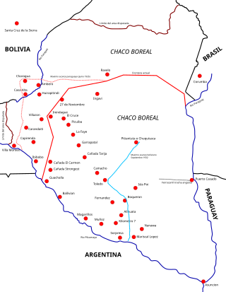
This was used as a port of transit for Paraguayan troops on their way to fight the Bolivians during the Chaco War.
The Carlos Casado Company came to have more than 5,000,000 hectares in the Paraguayan Chaco, today the factory is shut down. It is from here that Mennonites and Paraguayan soldiers passed, using the narrow-gauge trains of the Chaco Central railroad that extended 145 km west from the River Paraguay.
In Puerto Casado there are places of historical epoch of the Chaco War, the first Mennonite settlers arrived here in 1920.
Galvan Hill is located 5 km south of "Kilometro 11," the former railway station that left from Puerto Casado. The boat makes a high Aquidabán here, part of Concepcion. Another boat that is here for the "Cacique II," which part of Asuncion for Vallemí.
At Galvan Hill one can still see the old railroad tracks. Here Emiliano R. Fernández wrote his poem "The Fashion" in 1926. This is the first railroad station of importance along the railroad.
The railway was built by the company for the extraction of timber, with nearly 150 km of narrow gauge track into the heart of the Chaco. The same route of the railway was extended up to 160 km, which enabled the Paraguayan troops in campaign to access the fortresses to stop the advance of Bolivians in this vast territory during the Chaco War.
During the Chaco War of the railroad was vital to transport soldiers, arms, ammunition, supplies, vehicles, fuel, medicines and wounded.
The old Kilometro 11 station, a former house that was part of the old railway station of the Carlos Casado Company, is one of the historic landmarks still standing in the locality.
With the sale of public lands in the late nineteenth century was established company Carlos Casado Ltda., which acquired in 1886 over 7,800 square kilometres (3,000 sq mi), was devoted to logging and production of tannin. Tannin is a substance extracted from the "quebracho" tree, used for tanning hides. The son of the founder, José Casado, arrived in 1929 to manage the site, lived on site until 1945.
During the Chaco War, the facilities were used as workshops for all kinds of machinery, armaments, especially motor vehicles, before being sent into battle. It also was used as river port and military post.
In 1931 the Command Infantry Division was installed at the port, José Félix Estigarribia accepted the post of Commander that he proposed the then president Joseph P. Guggiari since late July, 1931 Estigarribia was already installed there. When the new commander settled in the place, the owner of the factory provided him with a house, called "La Chaqueña", a large and comfortable residence located in the city centre.
Emiliano R. Fernandez, popular poet and musician, often called the "northern poet," to 1923 was in Puerto Casado, where he performed several tasks. Often his works are signed as having been written in Alto Paraguay.
As for handicrafts, in the early 80's a former worker of the company had the idea of making a guampa (mate cup) for his own use from pieces of the stainless steel that was used to store tannin. The idea was warmly accepted and began to receive orders and the manufacturer improved technology and creating new models of guampa for drinking mate and terere. Today these are manufactured in various designs on special orders for gifts or as souvenirs of Puerto Casado.
In the Paraguay and Apa Rivers and in the many streams in the area, an important tourist activity is fishing.

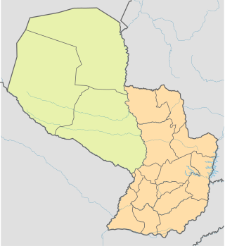
Paraguay is a country in South America, bordering Argentina, Bolivia and Brazil. The Paraguay River divides the country into strikingly different eastern and western regions. Both the eastern region and the western region gently slope toward and are drained into the Paraguay River, which separates and unifies the two regions. With the Paraneña region reaching southward and the Chaco extending to the north, Paraguay straddles the Tropic of Capricorn and experiences both subtropical and tropical climates.
Paraguay's transportation system ranges from adequate to poor, largely depending on the region of the country. The country has a network of roads, railroads, rivers, and airports, but significant infrastructure and regulation improvements are needed.

The Chaco War was fought from 1932 to 1935 between Bolivia and Paraguay, over the control of the northern part of the Gran Chaco region of South America, which was thought to be rich in oil. The war is also referred to as La Guerra de la Sed in literary circles since it was fought in the semi-arid Chaco. The bloodiest interstate military conflict fought in South America in the 20th century, it was fought between two of its poorest countries, both of which had lost territory to neighbours in 19th-century wars.

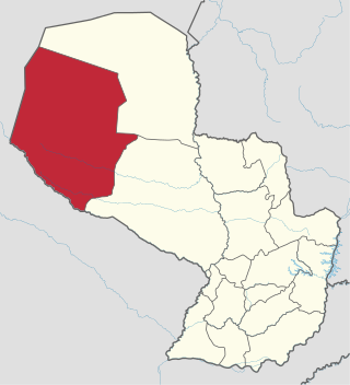
Boquerón is a department in the western region of Paraguay. It is the country's largest department, with an area of 91,669 km2 (35,394 sq mi), but, according to the statistics for 2021 by INE, its population is only 68,080, being the second least populated department. The department includes the Russian Mennonite colonies of Fernheim, Menno and its administrative center Loma Plata and Neuland. The capital is Filadelfia. Other towns are General Eugenio A. Garay, Doctor Pedro P. Peña and Mariscal Estigarribia.

Presidente Hayes is a department in Paraguay. The capital is the city of Villa Hayes. The department was named after U.S. President Rutherford B. Hayes, who awarded the territory to Paraguay while arbitrating a boundary dispute between Paraguay and Argentina after the Paraguayan War.

The Gran Chaco or Dry Chaco is a sparsely populated, hot and semiarid lowland tropical dry broadleaf forest natural region of the Río de la Plata basin, divided among eastern Bolivia, western Paraguay, northern Argentina, and a portion of the Brazilian states of Mato Grosso and Mato Grosso do Sul, where it is connected with the Pantanal region. This land is sometimes called the Chaco Plain.

The Paraguayan Chaco or Región Occidental is a semi-arid region in Paraguay, with a very low population density. The area is being rapidly deforested. Consisting of more than 60% of Paraguay's land area, but with less than 3% of the population, the Chaco is one of the most sparsely inhabited areas in South America.

San Juan Bautista, capital of the Department of Misiones, Paraguay, is considered the cradle of the religious mission culture. The city is the seat of the Roman Catholic Diocese of San Juan Bautista de las Misiones.

Pilar is the capital city of the Paraguayan department of Ñeembucú, located along the Paraguay River in the southwestern part of the country. Located about 258 km (160 mi) from Asunción, Pilar serves as an important center of commerce and government for the far southwestern region of the country.
Menno Colony is a Mennonite settlement located in the central part of the Chaco region, in northwest Paraguay, occupying an area of 7500 km² (2900 mi²). It was founded in 1926 by Plautdietsch-speaking descendants of Russian Mennonites who emigrated from Canadian provinces of Manitoba and Saskatchewan. Neighbouring Mennonite settlements are Fernheim Colony and Neuland Colony. The main settlement of the colony is Loma Plata. Menno is the largest of the Mennonite colonies in Paraguay.

Fort Borbón is a fort located in the Paraguayan Chaco; it was established to provide protection from the natives and Portuguese. After the Portuguese were expelled by Gaspar Rodríguez de Francia, it was changed to its present name Fort Olimpo.
Loma Plata is a city in the district (distrito) of the Department of Boquerón, Paraguay. It is located 407km from Asunción by a paved detour of 22km from the Ruta Transchaco. It is the main town of the Menno Colony, one of the Mennonite colonies of the Paraguayan Chaco.
The Gran Chaco is a plain of about 1.000.000 km2. It covers parts of Bolivia, Paraguay, Brazil and Argentina.
The Chaco War was the first major Latin American conflict in which aircraft were used. This aerial war carried a large human and materiel cost. At that time, Bolivia possessed one of the greatest aerial forces in the region, however this fact did not prevent its final defeat. Bolivia lacked the expertise to utilise its aerial forces, and was thus unable to maximise its use of military aviation. Paraguay had a small number of pilots and technicians, all veterans of the revolution of 1922. The 1922 revolution was a brief civil war in which the government and the rebels used aircraft in the operations, and José Félix Estigarribia could be considered an innovator in the military use of aircraft on the continent.

La Escondida is a village and municipality in Chaco Province in northern Argentina La Escondida in the region of Chaco with its 3,948 residents is located in Argentina - some 522 miles (840 km) north of Buenos Aires.
Quebracho is a common name in Spanish to describe very hard wood tree species. The etymology of the name derived from quiebrahacha, or quebrar hacha, meaning "axe-breaker". The corresponding English-language term for such hardwoods is breakax or breakaxe.

The Chamacoco people (Ishír) are an indigenous people of Paraguay. Some also live in Brazil.
The Forestal Land, Timber and Railways Company Limited, commonly known as La Forestal, was a British forestry company that operated in the region between the southern Chaco and northern Santa Fe provinces in Argentina. During the late 19th and early 20th centuries, La Forestal exploited the extensive quebracho forests in these provinces, becoming the leading global producer of tannin. The company played a significant role in establishing approximately 40 towns, constructed ports, laid down 400 kilometers of private railways, and operated around 30 factories. At its peak, La Forestal employed about 20,000 people.

The Humaitá-class gunboat was a two-unit class of riverine gunboats designed by Paraguayan naval engineer José Bozzano and built in Genoa, Italy, for the Paraguayan Navy from 1928 to 1931. The warships played a key role as fast armed transports during the Chaco War with Bolivia.

The February Revolution in Paraguay was a military coup d'état on February 17, 1936, that brought to power colonel Rafael Franco. The revolution marked the end of Liberal Party rule in Paraguay and started the ascendancy of military dictatorships that lasted for more than half a century.


