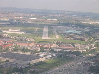
Buttonville Municipal Airport or Toronto/Buttonville Municipal Airport was a medium-sized airport in the neighbourhood of Buttonville in Markham, Ontario, Canada, 29 km (18 mi) north of Downtown Toronto, which closed in November 2023. It was operated by Torontair. Due to its location within Toronto's suburbs, there were several strict noise-reduction procedures for aircraft using the airport, which was open and staffed 24 hours a day, 365 days a year. In 2014, Buttonville was Canada's 20th busiest airport by aircraft movements. There was also a weather station located at the airport, which was still operational on the site but closed along with the airport.

North Bay Airport or North Bay/Jack Garland Airport in North Bay, Ontario, Canada is located at Hornell Heights, 4 nautical miles north-northeast of the city. It is located adjacent to Canadian Forces Base North Bay, operational since 1951, the operational control centre for Canadian operations of the North American Aerospace Defense Command.

Peterborough Airport is located 3 nautical miles south-southwest of the city of Peterborough, Ontario, Canada. It includes a main 7,000 by 100 ft asphalt runway oriented east-west, and a smaller 2,000 by 49 ft paved (2014) runway oriented northwest-southeast. A new terminal building was built in 2011. Aircraft completions company Flying Colours Corp. is the largest tenant at the airport.

Oshawa Executive Airport is a municipal airport adjacent to the north end of the city of Oshawa, Ontario, Canada. It is the busiest general aviation airport without scheduled airline service in the Greater Toronto Area by aircraft movements and one of the busiest general aviation only airports in Canada. It includes two paved runways and instrument approaches.

EarltonAirport is located 1 nautical mile southwest of Earlton, Ontario. The airport has a 5,998 by 150 ft paved runway (08-26) oriented east–west, and a 3,019 by 150 ft gravel/snow runway (16-34) oriented north–south.

Windsor International Airport is located in the southeast portion of the city of Windsor, Ontario, Canada. The airport serves a mixture of scheduled airline flights and general aviation, and is a popular point of entry into Canada for private and business aircraft. The airspace above the airport is exceptionally busy because of the proximity to Detroit Metropolitan Airport, and Instrument Flight Rules (IFR) arrivals and departures are handled by Detroit approach control.

Iqaluit Airport serves Iqaluit, Nunavut, Canada and is located adjacent to the city. It hosts scheduled passenger service from Ottawa, Montreal, Rankin Inlet, and Kuujjuaq on carriers such as Canadian North, and from smaller communities throughout eastern Nunavut. It is also used as a forward operating base by the Royal Canadian Air Force (RCAF). In 2011, the terminal handled more than 120,000 passengers.

Baker Lake Airport is located 3 nautical miles southwest of Baker Lake, Nunavut, Canada. It is operated by the government of Nunavut. It has a single gravel runway 4,195 ft × 100 ft.

Cambridge Bay Airport is located 1.6 nautical miles southwest of Cambridge Bay, Nunavut, Canada, and is operated by the government of Nunavut.

Gjoa Haven Airport is located 1.5 nautical miles northeast of Gjoa Haven, Nunavut, Canada, and is operated by the government of Nunavut.

Cranbrook/Canadian Rockies International Airport is an international airport located 5 nautical miles north of Cranbrook and 20 km (12 mi) south-east of Kimberley, British Columbia, in the Canadian Rockies.
Qikiqtarjuaq is a community located on Broughton Island in the Qikiqtaaluk Region of Nunavut, Canada. The island is known for Arctic wildlife, bird watching at the Qaqulluit National Wildlife Area. The community serves as the northern access point for Auyuittuq National Park and Pangnirtung is the southern access point.

Ulukhaktok/Holman Airport, located at Ulukhaktok, Northwest Territories, Canada was fully opened in December 1978 with the start of the Community Aerodrome Radio Station (CARS). However, aircraft had been using the runway prior to that as construction was completed in the summer of 1978.

Deer Lake Regional Airport is located 3 nautical miles north northeast of Deer Lake, Newfoundland and Labrador, Canada. It is currently run by the Deer Lake Regional Airport Authority and is the closest airport to Gros Morne National Park and Corner Brook. It is the second busiest airport on Newfoundland after St. John's International Airport serving 300,000 passengers annually. Deer Lake Airport serves a large area of Newfoundland, from the Great Northern Peninsula to Channel-Port aux Basques.

Kuujjuaq Airport is an airport located 1.5 nautical miles southwest of Kuujjuaq, Quebec, Canada.

Rimouski Aerodrome is a registered aerodrome located 1.8 nautical miles northeast of Rimouski, Quebec, Canada. It only handles general aviation and cargo flights.

Red Lake Airport is located 3 nautical miles north of Red Lake, Ontario, Canada.
Peace River Airport is a municipally owned airport located 5 nautical miles west of the Town of Peace River, Alberta, Canada. The airport has one runway, which is 5,000 ft × 150 ft, and a terminal building, which is 21,000 sq ft (2,000 m2).
Tofino-Long Beach Airport is a non-towered airport that is located within the Pacific Rim National Park Reserve. Immediately adjacent to Long Beach, it is 6 nautical miles southeast of Tofino, British Columbia, Canada.

Markham Airport or Toronto/Markham Airport is a private aerodrome operating 2.6 nautical miles north of Markham, Ontario, Canada near Toronto.


