
Pawtucket is a city in Providence County, Rhode Island. The population was 75,604 at the 2020 census, making the city the fourth-largest in the state. Pawtucket borders Providence and East Providence to the south, Central Falls and Lincoln to the north, and North Providence to the west. The city also borders the Massachusetts municipalities of Seekonk and Attleboro.

Saylesville is a village and historic district in Lincoln, Rhode Island.
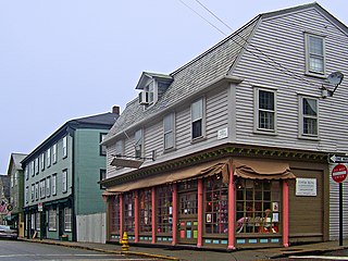
The Newport Historic District is a historic district that covers 250 acres in the center of Newport in the U.S. state of Rhode Island. It was designated a National Historic Landmark (NHL) in 1968 due to its extensive and well-preserved assortment of intact colonial buildings dating from the early and mid-18th century. Six of those buildings are themselves NHLs in their own right, including the city's oldest house and the former meeting place of the colonial and state legislatures. Newer and modern buildings coexist with the historic structures.

The Smith Hill Historic District is a historic district located in northwestern Providence, Rhode Island, just west of the Rhode Island State House and Interstate 95. It includes 57-65 Brownell Street, 73-114 Holden Street, 23-80 Jewett Street, 189-240 Smith Street and 10-18 W. Park Street. This area is a densely built residential section, an isolated remnant of what was once a larger residential area. Most of the 41 properties are residential units built between 1870 and 1930, and are typically 2-1/2 or 3+1⁄2 stories in height. They are set on lot sizes ranging generally from 3000 to 5000 square feet, and are set close to the sidewalk. The only major non-residential buildings are St. Patrick's School at 244 Smith Street and "The Mohican" at 185-189 Smith Street; the latter is an Art Deco brick and concrete commercial block two stories in height.

The Cato Hill Historic District is a residential historic district in central Woonsocket, Rhode Island. It consists of about 2-1/2 blocks of Church and Cato Streets, as well as the streets crossing them. The area, located on a hill just above Woonsocket's downtown area, is a densely populated area built primarily between 1838 and 1875, during Woonsocket's growth as a major textile processing center. Cato Hill is named for Cato Aldrich, an African American who purchased the land from the Arnolds who founded Woonsocket. The houses of the district exhibit vernacular forms of the architectural styles popular in the mid-19th century.
The North End Historic District is a historic district in Woonsocket, Rhode Island encompassing an affluent residential area developed predominantly between about 1880 and 1930. It is bounded by Harris Avenue on the west, Winter Street on the north, Summer and Prospect Streets to the east, and Spring and Blackstone Streets to the south. It is separated from Woonsockets commercial and industrial heart by a neighborhood of densely populated worker housing. Most of the district's 224 major buildings are of relatively high quality and in good condition, and are reflective of the architectural styles that predominated in the late 19th and early 20th centuries: Queen Anne Victorian, Colonial Revival, and Tudor Revival forms and styles are the most common seen.

The South Central Falls Historic District is a historic district in Central Falls, Rhode Island. It is a predominantly residential area, densely populated, which was developed most heavily in the late 19th century. It is bounded roughly by Broad Street to the east, the Pawtucket city line to the south, Dexter Street to the west, and Rand Street and Jenks Park to the north. It has 377 contributing buildings, most of which were built before 1920. The district was added to the National Register of Historic Places in 1991.

The Wayland Historic District is a predominantly residential historic district on the east side of Providence, Rhode Island. It is a large area, covering about 122 acres (49 ha), bounded roughly on the north by Everett and Laurel Avenues, on the east by Blackstone Boulevard and Butler Avenue, on the west by Arlington Avenue, and on the south by Angell and South Angell Streets. This area, which was in the 19th century part of the Moses Brown farm, was platted for development in 1891, with most of the construction taking place in the early decades of the 20th century. Most of the residential properties in the district are single-family houses, typically built in revival styles popular at the time. They are set on similarly sized lots with fairly uniform setbacks, and were typically built without garages. There are a number of two-family houses, and a small number of apartment buildings, most of which are found on the arterial roads of the area. There are several religious buildings, including several churches; the most architecturally distinctive religious building is the Jewish Temple Beth El, built 1951–54.

The Church Hill Industrial District is an industrial historic district on the west side of Pawtucket, Rhode Island. It encompasses an area that was intensively developed between about 1850 and 1920, and includes five separate industrial facilities. Four of these are relatively modest in size, and originally served a combination of textile mills and ironworks, the latter of which often manufactured parts used in the textile manufacturing processes. The oldest building is an 1848 ironworks facility, which runs along Pine Street between Main and Bayley. The largest single complex, added in the 2011 expansion of the district, is the Union Waddell complex between Bayley Street and the Amtrak railroad tracks, which has ten surviving buildings from the early 20th century.
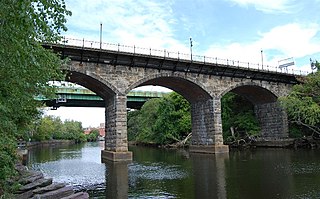
The Division Street Bridge is an historic roadway and sidewalk stone arch bridge in Pawtucket, Rhode Island, carrying Division Street over the Seekonk River. The structure was built in 1875–1877 at a cost of USD$95,000. It is a nine-span stone and brick bridge with a total length of about 450 feet (140 m), making it the "finest and longest" stone arch bridge in the state. It is said to be a symbolic icon of the unity of the two neighborhoods, which are divided by the river, coming together as the Town of Pawtucket. The bridge was listed on the National Register of Historic Places in 1983. Although it may be "functionally obsolete" relative to traffic patterns and in need of repairs, it is considered to be architecturally and historically significant.

The Fifth Ward Wardroom is a historic meeting hall at 47 Mulberry Street in Pawtucket, Rhode Island. It is a single-story red brick building, with a low-pitch hipped roof. Basically rectangular, an enclosed entry pavilion projects from the main block. The building was designed by William R. Walker & Son and built in 1886. Originally used as a polling place and meeting hall, it was later used as a school and by veterans organizations before being converted into a single family residence during its National Register of Historic Places nomination. It was listed on the historic register in 1983.

The Fuller Houses are two historic homes at 339-341 and 343-345 Broadway in Pawtucket, Rhode Island. Constructed in 1896–1897, the two Queen Anne-styled homes were constructed as rental properties for the Fuller family and are believed to have originally been identical in construction. The 2+1⁄2-story houses are marked by an octagonal bay which contains the front staircase and a large two-story porch projecting almost completely from the house itself. For the National Register of Historic Places nomination only a single unit was examined, but the identical unit below is believed to have undergone minimal alterations. The other house, 343-345 Broadway, was not surveyed, but has been more seriously modified to allow for four apartment units. The Fuller Houses are architecturally significant as well-preserved and well-detailed Queen Anne-styled apartment flats. The Fuller Houses were added to the National Register of Historic Places in 1983.

The Pawtucket Congregational Church is an historic church building at 40 and 56 Walcott Street, at the junction of Broadway and Walcott St., in the Quality Hill neighborhood of Pawtucket, Rhode Island.

The Pitcher-Goff House, is an historic house at 58 Walcott Street in the Quality Hill neighborhood of Pawtucket, Rhode Island. The house is architecturally eclectic, with a largely Italianate exterior, and a Late Victorian interior. The house was built for Elias B. Pitcher, a cotton textile manufacturer, in 1840. Later it was sold to Lyman B. Goff, another local industrialist, who made significant alterations to the interior, replacing a great deal of the older woodwork with more fashionable Queen Anne styling in 1881. He also modified the exterior, but these changes were largely limited to the porch, which also exhibits fine Queen Anne detailing.

St. Mary's Church of the Immaculate Conception Complex is an historic Roman Catholic church complex at 103 Pine Street in Pawtucket, Rhode Island.

St. John the Baptist Church is an historic Roman Catholic church at 68 Slater Street in Pawtucket, Rhode Island within the Diocese of Providence.

The Broadway–Armory Historic District is a historic district encompassing a mainly residential mixed-used urban area west of downtown Providence, Rhode Island.

The Southern Thames Historic District encompasses the commercial and residential area immediately to the south of the colonial center of Newport, Rhode Island. This area, covering about 135 acres (55 ha), was developed both residentially and commercially between about 1850 and 1920, with the majority of its growth coming in the late 19th century. It is characterized by densely built streets, including Thames Street, Newport's major north–south thoroughfare. The district includes the southern portion of Newport's waterfront, extending south from Memorial Boulevard along Thames and Spring Streets to Morton Street, and west to Marchant Street in its southernmost section. The district's housing stock and commercial architecture are largely vernacular wood-frame structures, set close to the sidewalk on small lots. The waterfront area is composed of wharves with warehouses and other structures, many of which have been converted to commercial use. One of the most prominent buildings in the district is the Emmanuel Episcopal Church, designed by Ralph Adams Cram and built in 1912–13.

Highland Heights–Stevens' Subdivision Historic District is a residential historic district located in Highland Park, Michigan along five east-west streets: Farrand Park, McLean Street, Colorado Street, Rhode Island Street, and Massachusetts Street, between Woodward Avenue on the west and Oakland Avenue on the east. The district was listed on the National Register of Historic Places in 1988.
The Downtown Pawtucket Historic District encompasses a major portion of the central business district of Pawtucket, Rhode Island. The city's downtown was developed primarily between 1871 and 1930, covering the period when it grew to become the second-largest city in the state. The district is irregularly shaped, including properties on Montgomery Street south of Manchester, and properties on Exchange, North Union, and Summer streets between Broad and High Streets, as well as a few properties on Main Street and Maple Street east of Park Place. It includes 50 buildings on 14 acres (5.7 ha), built in a cross-section of architectural styles from the late 18th century to the mid-20th century, although the main exterior construction material is brick. Most of the buildings are commercial in use, although there are three houses and a church included in the area.


