Quebec County, Quebec

Last updated

Quebec County was a historic county in the province of Quebec, Canada. The county included the Quebec City metropolitan area and extended northwestward. The county seat was Loretteville.

Contents

Quebec County was used as an electoral district in the first election held for members of the Legislative Assembly of Lower Canada in 1792.

Creation (1855)

Map of the municipalities of the County of Quebec, as they existed in January 1924. Comte de Quebec 01-01-1924.jpg
Map of the municipalities of the County of Quebec, as they existed in January 1924.

The County was established on July 1, 1855, [1] encompassing all municipalities and unorganized territory within the following limits: [2]

  • to the south: the Saint Lawrence River
  • to the north: the 48th parallel
  • to the west: the western limits of the parishes of Sainte-Foy, l'Ancienne-Lorette and Saint-Ambroise, and of the Seigniory of Saint-Gabriel and the prolongation thereof to the northern limit of the County
  • to the east: the southwestern line of the Seigniory of La Côte de Beaupré until it meets the southeastern line of the Township of Tewkesbury, then northeast to its eastern corner, then by its northeastern line to the rear thereof, and then by the prolongation of that line to the northern limit of the county
  • excepting the City of Quebec and the parishes of Notre-Dame-de-Quebec and Saint-Roch-de-Québec.

In 1896, in addition to the unorganized territory, the County comprised the following entities: [3]

In 1864, Saint-Colomb-de-Sillery was granted the powers of a county council for certain limited purposes. [6] [7]

Municipalities

The county included the following municipalities/townships:

Municipal reorganization (1970-1981)

The municipalities constituting the suburban area surrounding Quebec City were withdrawn from the County at the beginning of 1970 to form the Communauté urbaine de Québec .

When Quebec's county boundaries were redrawn into Regional County Municipalities the county was dissolved mostly into La Jacques-Cartier, with small parts going to Le Haut-Saint-Maurice and Portneuf.

See also

Further reading

Notes

  1. being that part of the parish of Notre-Dame-de-Québec lying outside the limits of the City of Quebec
  2. a seigniory lying north of Saint-Gabriel, measuring two leagues square, [4] created in 1698 but never settled or developed prior to the abolition of seigneurial tenure, and now forming part of the ZEC Batiscan-Neilson [5]

Related Research Articles

<span class="mw-page-title-main">Sainte-Foy, Quebec City</span> Districts in Quebec, Canada

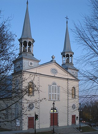
Sainte-Foy is a former city in central Quebec, Canada alongside the Saint Lawrence River. It was amalgamated into Quebec City at the start of 2002. Most of the formerly independent municipality of Sainte-Foy is located in the borough of Sainte-Foy–Sillery–Cap-Rouge — initially as one of the two constituent districts of the former borough of Sainte-Foy–Sillery. On 1 November 2009, Sainte-Foy was subdivided into four separate districts: Cité-Universitaire, Plateau, Saint-Louis, Pointe-de-Sainte-Foy, when the borough of Sainte-Foy–Sillery–Cap-Rouge was formed.

<span class="mw-page-title-main">Charlesbourg, Quebec City</span> Borough of Quebec City in Canada

Charlesbourg is a borough of Quebec City, in the northeastern part of the city, west of the borough of Beauport.

<span class="mw-page-title-main">L'Ancienne-Lorette</span> City in Quebec, Canada

L'Ancienne-Lorette is a city in central Quebec, Canada. It is a suburb of and an enclave within Quebec City. It was merged with Quebec City on January 1, 2002, as part of a 2000–2006 municipal reorganization in Quebec, but, after a 2004 referendum, it was reconstituted as a separate city on January 1, 2006.

<span class="mw-page-title-main">Capitale-Nationale</span> Administrative region in Quebec, Canada

Capitale-Nationale is one of the 17 administrative regions of Quebec. It is anchored by the provincial capital, Quebec City, and is largely coextensive with that city's metropolitan area. It has a land area of 18,797.45 km2. It reported a total resident population of 729,997 as of the Canada 2016 Census, with Quebec City having 73.7 percent of the total.

<span class="mw-page-title-main">Boroughs of Quebec City</span>

Quebec City is divided into six arrondissements or boroughs. These boroughs are the result of several waves of amalgamation and reorganization of the political boundaries of Quebec City.

The 2000–2006 municipal reorganization in Quebec resulted in large-scale amalgamation of smaller municipalities in Quebec into larger cities. It was undertaken by one administration, and modified and partially undone by its successor.

Montmorency was a federal electoral district in the province of Quebec, Canada, that was represented in the House of Commons of Canada from 1867 to 1917, and from 1968 to 2004.

<span class="mw-page-title-main">Quebec City metropolitan community</span> Metropolitan area in Quebec, Canada

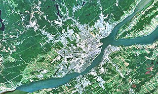
The Communauté métropolitaine de Québec (CMQ), or Quebec Metropolitan Community, is an administrative division of the province of Quebec, comprising the metropolitan area of Quebec City and Lévis. The CMQ is one of the two metropolitan communities of Quebec.

<span class="mw-page-title-main">Municipal history of Quebec</span> Aspect of Canadian history

The municipal history of Quebec started in 1796 with the creation of administrations for Montréal and Quebec City, but it really developed immediately prior to the creation of the Province of Canada in 1841 with the formation of municipal districts, followed in March 1845 when the Parliament of the Province of Canada adopted an Act to create local authorities in Lower Canada which took effect in July 1845.

Ligue Interzone de hockey mineur BC Rive Nord is an ice hockey league Based in the Quebec Metropolitan Area. It regroups many levels of hockey from Atom to Junior. It has two junior levels, Junior "A" and Junior "B".

<span class="mw-page-title-main">Saint-Gabriel-de-Valcartier</span> Municipality in Quebec, Canada

Saint-Gabriel-de-Valcartier is a municipality in the Capitale-Nationale region of Quebec, Canada, located in the Jacques-Cartier River valley. It is home to the Canadian Forces Base Valcartier since World War I.

<span class="mw-page-title-main">Rivière du Cap Rouge</span> River in Quebec, Canada

The Cap-Rouge river is a river flowing on the north shore of the Saint-Laurent river at the height of the Sainte-Foy–Sillery–Cap-Rouge borough of Quebec City and in the city of Saint-Augustin-de-Desmaures, both cities in the administrative region of Capitale-Nationale, in the province of Quebec, Canada.

<span class="mw-page-title-main">Communauté urbaine de Québec</span> Dissolved Region in Quebec, Canada

The Communauté urbaine de Québec was a regional municipal body that existed in the area around Quebec City from 1970 to 2001.

<span class="mw-page-title-main">Lorette River</span> River in Quebec, Canada

The Lorette River is a tributary of the Saint-Charles River, crossing the sector Sainte-Foy–Sillery–Cap-Rouge and the area of L'Ancienne-Lorette in Quebec City, in the administrative region of Capitale-Nationale, in the province of Quebec, Canada.

<span class="mw-page-title-main">Jaune River (Saint-Charles River tributary)</span> River in Capitale-Nationale (Québec, Canada)

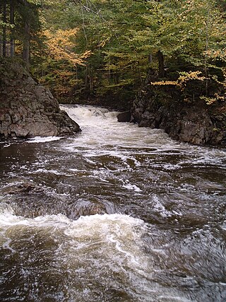
The Jaune River is a tributary of the Saint-Charles River flowing in the administrative region of Capitale-Nationale, in the province of Quebec, Canada. The course of the river crosses:

Quebec County was an electoral district of the Legislative Assembly of the Parliament of the Province of Canada, in Canada East, surrounding Quebec City. It was created in 1841 and was based on the previous electoral district of the same name for the Legislative Assembly of Lower Canada.

References

  1. Lower Canada Municipal and Road Act of 1855 , S.Prov.C. 1855, c. 100, s. 1, 7
  2. An Act to enlarge the Representation of the People of this Province in Parliament , S.Prov.C. 1853, c. 152, s. 18
  3. Deschamps 1896, p. 864.
  4. Chassé, Sonia; Girard-Wallot, Rita; Wallot, Jean-Pierre (1988). "Neilson, John". In Halpenny, Francess G (ed.). Dictionary of Canadian Biography . Vol. VII (1836–1850) (online ed.). University of Toronto Press.
  5. Lussier, Mario (2012). "Le fief Hubert : la noble terre inatteignable" (PDF). Bulletin d'information (in French). Quebec: Société d’histoire de La Haute-Saint-Charles. 9 (1): 14–15. Archived from the original (PDF) on 2017-01-18. Retrieved 2017-01-16.
  6. Deschamps 1896, pp. 485–486.
  7. An Act to extend the powers of the Local Municipality of St. Colombe de Sillery , S.Prov.C. 1864, c. 62

46°52′N71°16′W / 46.86°N 71.26°W / 46.86; -71.26