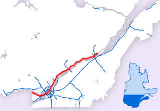
Autoroute 40, officially known as Autoroute Félix-Leclerc outside Montreal and Metropolitan Autoroute/Autoroute Métropolitaine within Montreal, is an Autoroute on the north shore of the St. Lawrence River in the Canadian province of Quebec. It is one of the two major connections between Montreal and Quebec City, the other being Autoroute 20 on the south shore of the St. Lawrence. Autoroute 40 is currently 347 km (215.6 mi) long. Between the Ontario–Quebec boundary and the interchange with Autoroute 25, the route is signed as part of the Trans-Canada Highway.

Route 138 is a major highway in the Canadian province of Quebec, following the entire north shore of the Saint Lawrence River past Montreal to the temporary eastern terminus in Kegashka on the Gulf of Saint Lawrence. The western terminus is in Elgin, at the border with New York State south-west of Montreal. Part of this highway is known as the Chemin du Roy, or King's Highway, which is one of the oldest highways in Canada.

Route 157 is a four-lane north/south highway on the north shore of the Saint Lawrence River in Quebec, Canada. Its northern terminus is in Shawinigan at the junction of Route 153, and the southern terminus is at the junction of Route 138 in Cap-de-la-Madeleine, now part of Trois-Rivières.

Provincial Highway 159 is a two-lane north/south highway on the north shore of the Saint Lawrence River in Quebec, Canada. Its northern terminus is in Saint-Roch-de-Mékinac at the junction of Route 155, and the southern terminus is at the junction of Route 138 in Sainte-Anne-de-la-Pérade.

Route 297 is short 25 km two-lane north/south highway in Quebec, Canada, which starts in Baie-des-Sables at the junction of Route 132 and ends in Saint-Moïse. The highway acts mainly as a shortcut between Baie-des-Sables and the southern section of Route 132 which leads to the Matapédia River Valley and the southern part of the Gaspé Peninsula.

Route 158 is an east-west arterial road running between Lachute and Berthierville, north of the Ottawa and Saint Lawrence rivers, in the Laurentides region.

Route 255 is a north/south highway on the south shore of the St. Lawrence River. Its northern terminus is in Baie-du-Febvre at the junction of Route 132 and its southern terminus is in Bury at the junction of Quebec Route 214.

Route 230 is a two-lane east/west provincial highway on the south shore of the Saint Lawrence River in the Bas-Saint-Laurent region of Eastern Quebec, Canada. Its eastern terminus is in Saint-Alexandre-de-Kamouraska east of the junction of Route 289 and the western terminus is at the junction of Route 132 in La Pocatière.

Route 170 is a major east/west highway on the north shore of the St. Lawrence River in Quebec, Canada, and it parallels the Saguenay River on the south side of it. The western terminus of Route 170 is in Métabetchouan–Lac-à-la-Croix at the junction of Route 169, at Lac Saint-Jean, and the eastern terminus is in Saint-Siméon, at the junction of Route 138, close to the Saint Lawrence River.

Route 172 is an east/west highway on the north shore of the St. Lawrence River in Quebec, Canada, and it parallels the Saguenay River on the north side of it. The western terminus of Route 172 is in Saint-Nazaire at the junction of Route 169, and the eastern terminus is in Tadoussac, at the junction of Route 138.
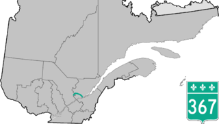
Route 367 is a 100 km two-lane north/south highway on the north shore of the Saint Lawrence River in Quebec, Canada. Although technically a north/south highway, long stretches of the road are east/west. Its northern/western terminus is close to Lac-aux-Sables at the junction of Route 363 and the southern/eastern terminus is in Saint-Augustin-de-Desmaures at the junction of Route 138. Route 367 used to stop in Rivière-à-Pierre, but in the late 1990s they have added the stretch between Rivière-à-Pierre and the junction of Route 363.

Route 111 is a north/south highway on the north shore of the Saint-Lawrence River in the Abitibi-Témiscamingue region of Quebec, Canada. Its northern terminus is in the municipality of Baie-James at the junction of Route 393, and its southern terminus is in Val-d'Or at the junction of Route 117.
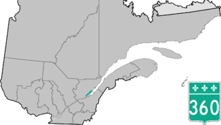
Route 360 is a provincial highway located in the Capitale-Nationale region in the south central part of the province of Quebec. The highway runs from Quebec City's Beauport sector and ends at the junction of Route 138 northeast of Saint-Tite-des-Caps in the Charlevoix region. For a large portion of its length it runs right beside Route 138, overlapping it briefly near Beaupré. The road also travels through significant portions of the Charlevoix touristic area and also crosses Mont-Sainte-Anne ski resort and the Montmorency Falls located at the Montmorency River which connects the Saint Lawrence River nearby.

Route 381 is a provincial highway located in the Capitale-Nationale and Saguenay–Lac-Saint-Jean regions of Quebec. It runs from Baie-Saint-Paul at the junction of Route 138 and ends in the La Baie sector of the City of Saguenay at the junction of Route 170.

Route 393 is a Quebec provincial highway located in the province's Abitibi-Témiscamingue and Nord-du-Québec regions. The highway runs from the junction of Route 101 in the Rouyn-Noranda suburb of Destor and ends in Val-Paradis in the municipality of Baie-James. In La Sarre it overlaps Route 111.

The Noire River is a tributary of the North-West shore of Saint Lawrence River flowing north-east of La Malbaie, in the municipality of Saint-Siméon, in Charlevoix-Est Regional County Municipality, in Quebec, in Canada.
The Rivière du Premier Rang is a tributary of the west bank of the Jean-Noël River flowing on the north bank of the Saint Lawrence River, in the municipalities of Saint-Hilarion and Les Éboulements, in the MRC of Charlevoix Regional County Municipality, in the administrative region of Capitale-Nationale, in the province of Quebec, in Canada.
The Rivière du Moulin is a tributary of the west shore of Saint-Paul Bay on the northwest shore of the St. Lawrence River. This river flows in the municipality of Petite-Rivière-Saint-François and in the city of Baie-Saint-Paul, in the Charlevoix Regional County Municipality, in the administrative region of Capitale-Nationale, in the province of Quebec, in Canada.
The Rivière des Boudreault is a tributary of the northwest shore of the St. Lawrence River, in the municipality of Les Éboulements, in the Charlevoix Regional County Municipality, in the administrative region of Capitale-Nationale, in the province of Quebec, in Canada.
The Chicago River is a tributary of the east bank of the middle part of the Rivière du Gouffre, flowing in the administrative region of Capitale-Nationale, in the province from Quebec, to Canada. The course of this river flows through the regional county municipalities (MRCs) of:

