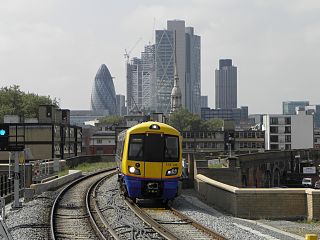
The East London line is part of the London Overground, running north to south through the East, Docklands and South areas of London. It was previously a line of the London Underground.

The North London line (NLL) is a railway line which passes through the inner suburbs of west, north-west, north, and north-east London, England between Richmond in the south-west and Stratford in the east, avoiding central London. Its route is a rough semicircle.

Old Street is an interchange station at the junction of Old Street and City Road in Central London for London Underground and National Rail services.
The Stoke Newington & Edmonton Railway was built by the Great Eastern Railway, under the GER Act of 29 July 1864. Construction was delayed due to the financial problems of the GER. Work commenced on the Hackney Downs to Lower Edmonton section in 1870. The section from Bethnal Green Junction to Stoke Newington with stations at Cambridge Heath, London Fields, Hackney Downs, Rectory Road, and Stoke Newington opened on 27 May 1872. The remainder opened on 22 July 1872 with stations at Stamford Hill, Seven Sisters, Bruce Grove, White Hart Lane, Silver Street, and Edmonton, then to Edmonton Green. The connection with the original branch line to Enfield Town north of Edmonton Green station was opened on 1 August 1872.

Dalston Kingsland railway station is a railway station on the North London Line in London, England. It is in the Dalston area of the London Borough of Hackney, on the western side of Kingsland High Street and opposite Ridley Road Market. The station and all trains serving it are operated by London Overground. It is in Travelcard Zone 2. Kingsland railway station was first opened on the site in 1850, but was replaced by Dalston Junction in 1865. The current station was opened by British Rail in 1983. Ticket barriers are in operation. The station straddles the boundary with the London Borough of Islington, with part of the platforms falling within Islington.

Epping is a London Underground station in the market town of Epping in Essex, England. The station serves as the north-eastern terminus of the Central line. Located in Travelcard Zone 6, it is one of eight London Underground stations in the Epping Forest District. The station before Epping is Theydon Bois, which is about three minutes' travelling time away.

Hackney Central is a London Overground station on the North London line in Hackney Central, north-east London. It lies between Dalston Kingsland and Homerton and is in Travelcard Zone 2. The station and all trains serving it are operated by London Overground services which are managed by Transport for London. However, there is no standard red National Rail "double arrow" logo signage at the station, instead only the Overground roundel.

East London is the northeastern part of London, England, east of the ancient City of London and north of the River Thames as it begins to widen. East London developed as London's docklands and the primary industrial centre. The expansion of railways in the 19th century encouraged the eastward expansion of the East End of London and a proliferation of new suburbs. The industrial lands of East London are today an area of regeneration, which are well advanced in places such as Canary Wharf and ongoing elsewhere.

Bethnal Green is a London Overground station on the Lea Valley lines in the southern part of Bethnal Green, in East London. The station is 1 mile 10 chains down the line from London Liverpool Street; the next station is either Hackney Downs or Cambridge Heath. It is an interchange station between three services operated by London Overground. Its three-letter station code is BET and it is in Travelcard zone 2.

Cambridge Heath is a railway station operated by London Overground in Cambridge Heath, East London. The station is 1 mile 61 chains (2.8 km) down the line from London Liverpool Street and is situated between Bethnal Green and London Fields on the Lea Valley lines to Cheshunt and Enfield Town. Its three-letter station code is CBH and it is in Travelcard zone 2.

London Fields is a London Overground station on the Lea Valley Lines, serving the district of London Fields in the London Borough of Hackney, east London. It is 2 miles 35 chains (3.9 km) down-line from London Liverpool Street and is situated between Cambridge Heath and Hackney Downs. Its three-letter station code is LOF and it is in Travelcard zone 2.
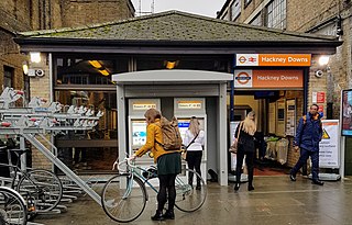
Hackney Downs is a London Overground and National Rail station in Hackney Central and serves the old common land of Hackney Downs in Lower Clapton in the London Borough of Hackney, it is on the Lea Valley lines and West Anglia Main Line. It is 2 miles 78 chains (4.8 km) down the line from London Liverpool Street and has a direct passenger link to Hackney Central station, providing interchange with the North London line of the Overground network.
Ponders End railway station is on the West Anglia Main Line, serving the district of Ponders End in the London Borough of Enfield, north London. It is 9 miles 71 chains (15.9 km) down the line from London Liverpool Street and is located between Meridian Water and Brimsdown. Its three-letter station code is PON and it is in Travelcard zone 5.

The Lea Valley lines are two commuter lines and two branches in north-east London, so named because they run along the Lower Lea Valley of the River Lea. They were part of the Great Eastern Railway, now part of the Anglia Route of Network Rail.

Broxbourne railway station is on the West Anglia Main Line serving the towns of Broxbourne and Hoddesdon in Hertfordshire, England. It is 17 miles 17 chains (27.7 km) down the line from London Liverpool Street and is situated between Cheshunt and Roydon. Its three-letter station code is BXB and it is in fare zone B.

The West Anglia Main Line is one of the two main lines that operate out of Liverpool Street. It runs generally north through Cheshunt, Broxbourne, Harlow, Bishop's Stortford and Audley End to Cambridge, with branches between serving Stratford, Hertford and Stansted Airport. The line runs along the boundary between Hertfordshire and Essex for much of its length.

Dalston Junction is an inter-modal rail and bus transport interchange in Dalston, London. It is located at the crossroads of Dalston Lane, Kingsland Road and Balls Pond Road. The station served by London Overground East London line and is in Zone 2. The station is located in a short section of cut and cover tunnel north of the Kingsland Viaduct.

Victoria Park was a railway station near Victoria Park, east London, that was on the North London Railway (NLR) which opened in September 1850 to Bow and to the London Docks in January 1852.
Lower Edmonton railway station was a station in Edmonton, London opened in 1849 by the Eastern Counties Railway as part of the original Enfield Town branch line. Originally named Edmonton it was renamed as Lower Edmonton low level to distinguish it from neighbouring Lower Edmonton high level. It closed to passengers in 1939 although the line on which it stood lasted until 1964.

Hackney is a district in East London, England, forming around two-thirds of the area of the modern London Borough of Hackney, to which it gives its name. It is 4 miles (6.4 km) northeast of Charing Cross and includes part of the Queen Elizabeth Olympic Park. Historically it was within the county of Middlesex.