
Queensland Cement and Lime Company (QCL) was a company that manufactured cement and lime for use in construction in Queensland, Australia. [1] It supplied many major projects in Queensland. It was also known as Queensland Cement Limited.
Queensland Cement and Lime Company (QCL) was a company that manufactured cement and lime for use in construction in Queensland, Australia. [1] It supplied many major projects in Queensland. It was also known as Queensland Cement Limited.
The company was established in 1914, operating a cement factory at Station Road (now Station Avenue), Darra in Brisbane ( 27°33′53″S152°57′03″E / 27.5646°S 152.9508°E ). From 1916, it obtained limestone from Gore on the Darling Downs. In the early 1930s, it built Oxley Wharf on the Brisbane River at Seventeen Mile Rocks ( 27°32′40″S152°57′52″E / 27.5444°S 152.9645°E ). [2] The company had a dredge at Mud Island in Moreton Bay from where they obtained coral, which was then transported up the river to the wharf from where it was conveyed via the company's private road to the Darra factory. By 1936, the company ceased using limestone from Gore in favour of the coral from Moreton Bay. [1]

In the decade following World War II the company acquired the Australian Army ship Crusader and the former HMAS LST 3022 after they were decommissioned from military service. These vessels were renamed Cementco and Coral respectively, and were extensively modified for their new roles. Coral was used to dredge coral from Morton Bay, and Cementco transported the material up the Brisbane River to the company's cement factory at Darra. [3]

In 1969, the road transport was replaced by a 3.5 km overhead conveyor. In 1988 the company was renamed Queensland Cement Limited following some company mergers. In 1995, the company was unable to renew its dredging licences for Moreton Bay, leading to the closure of the Darra factory in 1998 after its stockpile was completely exhausted. [1]
In 2003, the company merged with Australian Cement Holdings to create Cement Australia, which (as at 2020) still has some facilities at Station Avenue within a large industrial estate. [4]
The company's wharf site at Seventeen Mile Rocks was taken over by Brisbane City Council in 1990. The council developed the site into the Rocks Riverside Park which opened in December 2003. The park incorporates elements of its industrial heritage.
The locality of Cement Mills in the Goondiwindi Region is located at the site of the company's works near Gore. [5]

The Brisbane River is the longest river in South East Queensland, Australia, and flows through the city of Brisbane, before emptying into Moreton Bay on the Coral Sea. John Oxley, the first European to explore the river, named it after the Governor of New South Wales, Sir Thomas Brisbane in 1823. The penal colony of Moreton Bay later adopted the same name, eventually becoming the present city of Brisbane. The river is a tidal estuary and the water is brackish from its mouth through the majority of the Brisbane metropolitan area westward to the Mount Crosby Weir. The river is wide and navigable throughout the Brisbane metropolitan area.
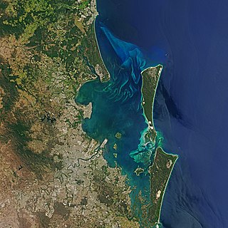
Moreton Bay is a bay located on the eastern coast of Australia 14 kilometres (8.7 mi) from central Brisbane, Queensland. It is one of Queensland's most important coastal resources. The waters of Moreton Bay are a popular destination for recreational anglers and are used by commercial operators who provide seafood to market.

Inala is a south-western suburb in the City of Brisbane, Queensland, Australia. In the 2021 census, Inala had a population of 15,273 people.

Oxley is a south-western suburb in the City of Brisbane, Queensland, Australia. In the 2016 census, Oxley had a population of 8,336 people.
Darra is a south-western suburb in the City of Brisbane, Queensland, Australia. In the 2016 census, Darra had a population of 4,343 people.
Rocks Riverside Park is a park by the Brisbane River in Seventeen Mile Rocks, Brisbane, Queensland, Australia. The park was opened on 7 December 2003, and features industrial artefacts from its previous use by the Queensland Cement and Lime Company. Public art which draws upon the park's industrial heritage are also featured throughout, as is a crop patch which reflects the site's farming days.

Goodna is a suburb on the eastern edge of the City of Ipswich in Queensland, Australia. In the 2016 census, Goodna had a population of 10,461 people.

Wacol is a suburb in the City of Brisbane, Queensland, Australia. In the 2016 census, Wacol had a population of 3,761 people.

Seventeen Mile Rocks is a suburb in the City of Brisbane, Queensland, Australia. In the 2016 census, Seventeen Mile Rocks had a population of 2,720 people.

Richlands is an outer south-western suburb in the City of Brisbane, Queensland, Australia. In the 2016 census, Richlands had a population of 3,598 people.

HMAS LST 3022 was a Mark 3 Landing Ship Tank (LST) operated by the Royal Navy during World War II, and the Royal Australian Navy (RAN) from 1946 until 1954.
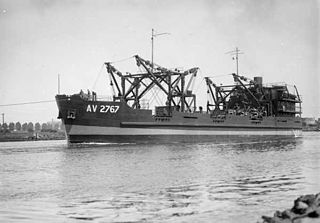
Crusader (AV2767) was an Australian Army amphibious operations support ship of World War II. She was launched shortly before the war ended and entered service in late 1935. From 1945 to 1947 she was mainly used to return Australian Army equipment from the islands off New Guinea. She was also loaned to the Australian Shipping Board in early 1947 and transported earth moving equipment and timber between Melbourne and Tasmania. However, the Army did not need a ship with Crusader's capabilities after the war, and she was sold in 1947 to the Queensland Cement and Lime Company which operated her as a coral barge on the Brisbane River until the mid-1980s. The ship was scuttled in 1986 and became a popular dive wreck.

Theophilus Parsons Pugh (1831–1896) was an Australian journalist, newspaper editor, politician, publisher and public servant, as well as the editor-in-chief of the Moreton Bay Courier, which he in 1861 renamed to The Courier, renamed again in 1864 to the Brisbane Courier.

The Shire of Sherwood is a former local government area of Queensland, Australia, located in south-western Brisbane in and around the suburb of Sherwood.

Langshaw Marble Lime Works is a heritage-listed remains of a former lime kiln at 12 Julius Street, New Farm, City of Brisbane, Queensland, Australia. It was built from c. 1878 to c. 1881. It was added to the Queensland Heritage Register on 13 October 1997.

The Moreton Bay Penal Settlement operated from 1825 to 1842. It became the city of Brisbane, Queensland, Australia.
Ipswich Town Wharves are heritage-listed remnants of wharves beside the Bremer River at Bremer Street, North Ipswich, City of Ipswich, Queensland, Australia. They were built from 1847 to c. 1927. They were also known as Australasian Steam Navigation Wharf and William Collins and Son Wharf, J & G Harris Wharf, and Walter Gray and Co Wharf. They were added to the Queensland Heritage Register on 31 July 2006.

James Campbell (1830–1904) was a Scottish merchant of timber and other building products based in Brisbane, Queensland, Australia. He founded the hardware firm James Campbell and Sons.
Cement Mills is a rural locality in the Goondiwindi Region, Queensland, Australia. In the 2016 census, Cement Mills had a population of 13 people.

The geography of Brisbane is characterised by its coastal location in the south eastern corner of the Queensland state of Australia. It is located halfway up the Australian east coast with longitudinal and latitudinal coordinates of 27.5° south and 153° east. The city resides within the Moreton Bay Floodplain, stretching from Caboolture to the north, Beenleigh to the south and as far as Ipswich to the west whilst being bordered by the Pacific Ocean to the east.