
Markham is a city in the York Region of Ontario, Canada. It is approximately 30 km (19 mi) northeast of Downtown Toronto. In the 2021 Census, Markham had a population of 338,503, which ranked it the largest in York Region, fourth largest in the Greater Toronto Area (GTA), and 16th largest in Canada.

Newmarket is a town and regional seat of the Regional Municipality of York in the Canadian province of Ontario. It is part of Greater Toronto in the Golden Horseshoe region of Southern Ontario. The name stems from the fact that the settlement was a "New Market", in contrast to York as the Old Market.

The Regional Municipality of York, also called York Region, is a regional municipality in Southern Ontario, Canada, between Lake Simcoe and Toronto. The region was established after the passing of then Bill 102, An Act to Establish The Regional Municipality of York, in 1970. It replaced the former York County in 1971, and is part of the Greater Toronto Area and the inner ring of the Golden Horseshoe. The regional government is headquartered in Newmarket.

Keswick (/ˈkɛzˌwɪk/) is a community located in the Canadian province of Ontario. Situated in Cook's Bay on Lake Simcoe, 72 km (45 mi) north of Toronto. Keswick is part of the Town of Georgina, the northernmost municipality in the Regional Municipality of York. In the Canada 2016 Census, the municipal population of Keswick was 26,757.

East Gwillimbury is a town on the East Holland River in the upper-tier municipality the Regional Municipality of York. It is part of the Greater Toronto Area of southern Ontario, in Canada. It was formed by the amalgamation of the Township of East Gwillimbury with all the previously incorporated villages and hamlets within the township. The main centres in East Gwillimbury are the villages of Holland Landing, Queensville, Sharon, and Mount Albert. The Civic Centre are located along Leslie Street in Sharon. The northernmost interchange of Highway 404 is at the North edge of East Gwillimbury, just south of Ravenshoe Road. The hamlets of Holt and Brown Hill are also within town limits.

Innisfil is a town in Ontario, Canada, located on the western shore of Lake Simcoe in Simcoe County, immediately south of Barrie and 80 kilometres (50 mi) north of Toronto. It has historically been a rural area, but since it is geographically sandwiched between the high-growth areas of Barrie and the York Region, there has been growing residential development in Innisfil.
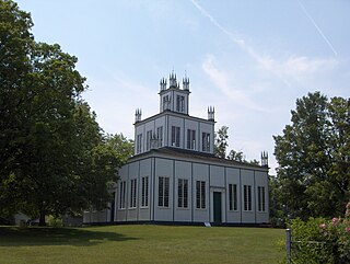
Sharon is a former village now incorporated into the municipality of the Town of East Gwillimbury, Ontario, Canada, formerly the Township of East Gwillimbury. The municipal offices of the town are in Sharon.

Bradford is the primary country urban area of the Town of Bradford West Gwillimbury, Ontario, in Canada. It overlooks a farming community, known as The Holland Marsh, located on the Holland River that flows into Lake Simcoe.

Tay is a township in Central Ontario, Canada, located in Simcoe County in the southern Georgian Bay region. The township was named in 1822 after a pet dog of Lady Sarah Maitland (1792–1873), wife of Sir Peregrine Maitland, Lieutenant Governor of Upper Canada. Two other adjoining townships were also named for her pet dogs, Tiny and Flos.
The Don Mills Centre was a shopping mall in Toronto, Ontario, Canada. It was located on a 44-acre commercial site, at the southwest corner of Don Mills Road and Lawrence Avenue East in Toronto. There were at least 98 stores during the height of the mall's existence. The majority of the mall was closed and demolished in summer 2006 for redevelopment as the Shops at Don Mills.

York—Simcoe is a federal electoral district in Ontario, Canada, that has been represented in the House of Commons of Canada from 1968 to 1979, from 1988 to 1997 and since 2004.

Bathurst Street is a main north–south thoroughfare in Toronto, Ontario, Canada. It begins at an intersection of the Queens Quay roadway, just north of the Lake Ontario shoreline. It continues north through Toronto to the Toronto boundary at Steeles Avenue. It is a four-lane thoroughfare throughout Toronto. The roadway continues north into York Region where it is known as York Regional Road 38.
King's Highway 48, also known as Highway 48, is a provincially maintained highway in southern Ontario that extends from Major Mackenzie Drive in Markham, through Whitchurch-Stouffville and East Gwillimbury, to Highway 12 south-east of Beaverton. The route is generally rural and straight, passing near several communities within the Regional Municipality of York. The route is 65.2 kilometres (40.5 mi) long. Most part of the road has a speed limit of 80 km/h (50 mph), except within town limits, where the speed limit is reduced to 60 km/h (37 mph) or 50 km/h (31 mph).

Holland Landing is a community in the town of East Gwillimbury, located in the northern part of the Regional Municipality of York, in south-central Ontario, Canada. Its major road is Yonge Street and the community has bus service by GO Transit route 68 and York Region Transit route 52. The East Gwillimbury GO train station is in the southeast corner of Holland Landing, providing weekday commuter train service. The East Holland River runs through the community and has several marinas for recreational boats.
Mount Albert is a village located within the Town of East Gwillimbury and is part of York Region. It is located 65 km north-east of Toronto, 21 km south of Sutton, 45 km west-southwest of Beaverton and 30 km north of Markham. Mount Albert is accessible by Highway 404 and Highway 48.

Sutton is a suburban community located nearly 2 km south of Lake Simcoe in Ontario, Canada. The community was formerly a village but is now part of the Town of Georgina after amalgamation with it and North Gwillimbury in 1971. The Black River runs on the north end of the downtown. Highway 48 goes just south of the downtown. Sutton has a population of just over 6,000 people. Sutton is located about 1 hour north of Toronto.
The East Holland River is a river in Ontario, Canada that is part of the Holland River watershed that empties into Cook's Bay in Lake Simcoe. The headwaters of the East Holland River rise in the Oak Ridges Moraine. The river runs generally north from the town of Newmarket, and through Holland Landing where it joins up with the West Holland River.

Cramahe is a rural township located in Northumberland County in southern Ontario, Canada. It is situated just off Ontario Highway 401 approximately 140 km East of Toronto. It was named for Hector Theophilus de Cramahé, who was Lieutenant-Governor of the Province of Quebec. The township's seat and largest town is Colborne.
Hagerman's Corners is a dispersed rural community in Markham, Ontario, Canada. Located at 14th Avenue and Kennedy Road, the former farm lands have disappeared and given way to homes and commercial parks. It is geographically located between the communities of Milliken Mills and Unionville, within the city of Markham.
Vandorf is a hamlet located in the town of Whitchurch–Stouffville, Ontario, in Canada. It is the most westerly settlement within the Town of Whitchurch-Stouffville. With a population of approximately 722, Vandorf consists mainly of estate residential homes and farms.
