R-18 regional road (Montenegro)

Last updated
Wegschild Montenegro R-18.svg
R-18 regional road
Regionalni put R-18
R-18 regional road MNE 2016.svg
Route information
Length34.2 km (21.3 mi)
Major junctions
East endWegschild Montenegro M-6.svg M-6 in Pljevlja
West end Šula
Location
Country Montenegro
Municipalities Pljevlja
Highway system
Wegschild Montenegro R-17.svg R-17 Wegschild Montenegro R-19.svg R-19

R-18 regional road (Montenegrin : Regionalni put R-18) (previously part of M-8 highway) is a Montenegrin roadway. [1]

Contents

History

M-6 highway was built as part of the larger M-8 highway within the Yugoslav highway network, spanning Bosnia and Herzegovina, Montenegro and Serbia. It connected Pljevlja with Foča in Bosnia and Herzegovina, and Prijepolje, Sjenica and Novi Pazar in Serbia. [2] However, construction was never completed on the Montenegrin section of the road. [3]

In January 2016, the Ministry of Transport and Maritime Affairs published bylaw on categorisation of state roads. [1] With new categorisation, part of M-8 highway (west of Pljevlja) was downgraded to regional road and named as R-18 regional road.

Major intersections

MunicipalityLocationkmmiDestinationsNotes
Pljevlja Pljevlja 0.00.0Wegschild Montenegro M-6.svg M-6  Žabljak, Prijepolje in Serbia
Gradac 23.414.5
No major intersection
Šula 34.421.4
Road ends in Šula, no major intersesction
1.000 mi = 1.609 km; 1.000 km = 0.621 mi

Related Research Articles

<span class="mw-page-title-main">Pljevlja</span> Town and municipality in Montenegro

Pljevlja is a town and the center of Pljevlja Municipality located in the northern part of Montenegro. The town lies at an altitude of 770 m (2,530 ft). In the Middle Ages, Pljevlja had been a crossroad of the important commercial roads and cultural streams, with important roads connecting the littoral with the Balkan interior. In 2011, the municipality of Pljevlja had a population of 30,786, while the city itself had a population of about 19,489 making it the fourth largest urban settlement in Montenegro. The municipality borders those of Žabljak, Bijelo Polje and Mojkovac in Montenegro, as well as Bosnia and Herzegovina to the west and Serbia to the northeast. With a total area of 1,346 km2 (520 sq mi), it is the third largest municipality in Montenegro.

<span class="mw-page-title-main">Sandžak</span> Geographical region in Serbia and Montenegro

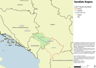
Sandžak, also known as Sanjak, is a historical geo-political region in Serbia and Montenegro. The name Sandžak derives from the Sanjak of Novi Pazar, a former Ottoman administrative district founded in 1865. Serbs usually refer to the region by its medieval name of Raška.

<span class="mw-page-title-main">Sanjak of Novi Pazar</span> Sanjak of the Ottoman Empire from 1865 to 1902

The Sanjak of Novi Pazar was an Ottoman sanjak that was created in 1865. It was reorganized in 1880 and 1902. The Ottoman rule in the region lasted until the First Balkan War (1912). The Sanjak of Novi Pazar included territories of present-day northeastern Montenegro and southwestern Serbia, also including some northern parts of Kosovo. In modern day terms, the borders of the region is known as Sandžak.

<span class="mw-page-title-main">Zeta Banovina</span>

The Zeta Banovina, was a province (banovina) of the Kingdom of Yugoslavia between 1929 and 1941. This province consisted of all of present-day Montenegro as well as adjacent parts of Central Serbia, Croatia, Kosovo and Bosnia and Herzegovina. It was named after the Zeta River which also gave its name to the medieval state of Zeta that roughly corresponds to modern-day Montenegro. The capital of Banovina was Cetinje.

<span class="mw-page-title-main">Ćehotina</span> River in Montenegro, Bosnia and Herzegovina

The Ćehotina, also known as the Ćeotina, Ćotina or Čehotina, is a 125 kilometres (78 mi) long river in Montenegro and Bosnia and Herzegovina. It is a right bank tributary of the Drina river.

Gradac may refer to:

<span class="mw-page-title-main">Sandžak Muslim militia</span> Military unit

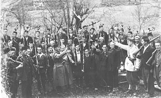
The Sandžak Muslim militia was established in Sandžak and eastern Herzegovina in Axis occupied Yugoslavia between April or June and August 1941 during World War II. It was under control of the Independent State of Croatia until September 1941, when Italian forces gradually put it under their command and established additional units not only in Sandžak, but in eastern Herzegovina as well. After the capitulation of Italy in September 1943 it was put under German control, while some of its units were merged with three battalions of Albanian collaborationist troops to establish the "SS Polizei-Selbstschutz-Regiment Sandschak" under command of the senior Waffen SS officer Karl von Krempler.

<span class="mw-page-title-main">M-10 highway (Montenegro)</span> Highway in Montenegro

M-10 highway is a Montenegrin roadway.

<span class="mw-page-title-main">R-19 regional road (Montenegro)</span> Road in Montenegro

R-19 regional road is a Montenegrin roadway.

<span class="mw-page-title-main">M-6 highway (Montenegro)</span> Highway in Montenegro

M-6 highway is a Montenegrin roadway.

<span class="mw-page-title-main">M-7 highway (Montenegro)</span> Highway in Montenegro

M-7 highway is a Montenegrin roadway.

<span class="mw-page-title-main">M-1 highway (Montenegro)</span> Highway in Montenegro

M-1 highway is a Montenegrin roadway.

<span class="mw-page-title-main">R-2 regional road (Montenegro)</span> Road in Montenegro

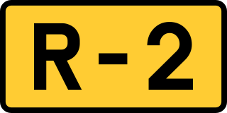
R-2 regional road is a Montenegrin roadway.

<span class="mw-page-title-main">R-3 regional road (Montenegro)</span> Road in Montenegro

R-3 regional road is a Montenegrin roadway.

<span class="mw-page-title-main">R-4 regional road (Montenegro)</span> Road in Montenegro

R-4 regional road is a Montenegrin roadway.

<span class="mw-page-title-main">R-7 regional road (Montenegro)</span> Road in Montenegro

R-7 regional road is a Montenegrin roadway.

<span class="mw-page-title-main">R-9 regional road (Montenegro)</span> Roadway

R-9 regional road is a Montenegrin roadway.

<span class="mw-page-title-main">R-11 regional road (Montenegro)</span> Road in Montenegro

R-11 regional road is a Montenegrin roadway.

<span class="mw-page-title-main">R-13 regional road (Montenegro)</span> Road in Montenegro

R-13 regional road is a Montenegrin roadway.

References

  1. 1 2 "Pravilnik o kategorizaciji državnih puteva" [Regulation on categorisation of state roads]. www.sluzbenilist.me (in Montenegrin). Official Gazette of Montenegro. 5 January 2016. Retrieved 18 June 2017.
  2. "Odluka o utvrđivanju magistralnih puteva" [Decision on determining highways](PDF) (in Serbo-Croatian). Federal Executive Council. 1984. Archived from the original (PDF) on 24 September 2015. Retrieved 27 May 2015. 8. put Foča - Pljevlja - Prijepolje - Sjenica - Novi Pazar;
  3. Doderović, Miroslav; Ivanović, Zdravko (Fall 2012). Drumski saobraćaj u Crnoj Gori [Vehicular transport in Montenegro](PDF) (in Montenegrin). Matica crnogorska. p. 482. Retrieved 24 May 2015. "Magistralni put Pljevlja – Gradac – Šula (granica sa BiH) je veza Pljevalja sa Fočom, a dionica Pljevlja - Gradac zahtijeva rekonstrukciju sa popravkom horizontalnih elemenata i kompletnu rehabilitaciju kolovoza. Izgradnja magistralnog puta Šula – granica sa BiH je nastavak putnog pravca Pljevlja –Gradac