RRH Staxton Wold

Last updated

RRH Staxton Wold
Ensign of the Royal Air Force.svg
Near Scarborough, North Yorkshire in England
R.A.F. Staxton Wold - geograph.org.uk - 1330500.jpg
RAF Staxton Wold
RAF Staxton Wold Badge.jpg
Vigilamus et Defendimus
(Latin for 'We Watch and We Ward') [1]
North Yorkshire UK location map (2023).svg
Red pog.svg
RRH Staxton Wold
Shown within North Yorkshire
Coordinates 54°11′11″N000°26′04″W / 54.18639°N 0.43444°W / 54.18639; -0.43444
Type Remote Radar Head
Area13 hectares (32 acres) [2]
Height574 feet (175 m)
Site information
Owner Ministry of Defence
Operator Royal Air Force
Controlled by No. 1 Group (Air Combat)
ConditionOperational
Radar type Lockheed Martin AN/TPS-77 (Type 92) Air Defence Radar
Site history
Built1936 (1936)
In use1937 – present
Garrison information
OccupantsRadar Flight (South)

RemoteRadarHeadStaxton Wold or RRH Staxton Wold is an air defence radar station operated by the Royal Air Force, located near Scarborough in North Yorkshire, England. [3] As it has been a radar site continuously since 1939, it has a claim to be the oldest working radar station in the world.

Contents

History

The present-day site of RRH Staxton Wold has had an early warning function since the 3rd century AD, when it was the site of a warning beacon. It was first selected to be used as a radar station in 1937, when it was set up as part of the Chain Home system, being some 574 feet (175 m) above sea level and only 4 miles (6.4 km) inland of the Yorkshire Coast. [4] [5] Building work did not begin until December 1938 as delays in procuring the site occurred when the landowners resisted selling (this being before the Second World War, so the government found it harder to demand the land by force for the war effort). [6]

The site became fully operational in April 1939 and is the only one of the original stations still in use, and may thus claim to be the oldest continuously serving radar station. [7] Just before the outbreak of war (July 1939), the base was equipped with a Bofors anti-aircraft gun, [8] and by December 1939, it was only one of two operational radar stations in Yorkshire (the other being Danby Beacon). [9] For six weeks during late 1939, Sir Bernard Lovell was posted to Staxton Wold from the University of Manchester whilst assessing radar at the site. [10]

Maintenance and operating staff were drawn from No. 73 Wing RAF, part of No. 60 Group RAF, with administrative and other human necessities catered for by RAF Church Fenton. [11] In the 1990s, the station was maintained and operated by No. 129 Signals Unit, and was part of Sector 2 headquartered by RAF Neatishead, which covered the southern half of the United Kingdom. [12]

In the 1950s, with the threat of aerial bombardment on the station, the RAF installed service fire-fighters at the base, who would tackle fires until North Yorkshire Fire and Rescue Service (NYF&RS) would arrive to assist. In the 1980s, the RAF fire-fighters were asked to attend local incidents in their area until the NYF&RS arrived to take control. However, by the early 21st century, the base was largely automated and the fire-fighters were removed from Staxton Wold. [13]

During July 1990 the Type 85 radar was decommissioned after 23 years of use, it was replaced by the Type 93. [14]

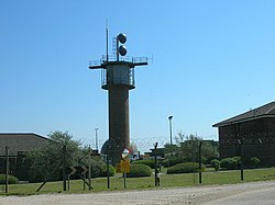
Today it is a Remote Radar Head (RRH) within the United Kingdom Air Surveillance and Control System (UKASACS). [15] The radar at Staxton Wold is a Lockheed Martin AN/TPS-77 radar which was due to be working by September 2013, [16] but only became fully operational in early 2015. [17] In September 2017, it was reported that the TPS-77 at Staxton Wold would be transferred to RRH Saxa Vord. [18]

As part of a major upgrade of RRH sites around the U.K. the MOD began a programme titled HYDRA in 2020 to install new state-of-the-art communications buildings, radar towers and bespoke perimeter security. [19] [20]

Notable personnel

See also

Related Research Articles

<span class="mw-page-title-main">NATO Integrated Air Defense System</span> NATO Air defence radar network

The NATO Integrated Air Defense System is a command and control network combining radars and other facilities spread throughout the NATO alliance's air defence forces. It formed in the mid-1950s and became operational in 1962 as NADGE. It has been constantly upgraded since its formation, notably with the integration of Airborne Early Warning aircraft in the 1970s. The United Kingdom maintained its own network, but was fully integrated with the network since the introduction of the Linesman/Mediator network in the 1970s. Similarly, the German network maintained an independent nature through GEADGE.

<span class="mw-page-title-main">ROTOR</span> 1950s British air defence radar system

ROTOR was an elaborate air defence radar system built by the British Government in the early 1950s to counter possible attack by Soviet bombers. To get it operational as quickly as possible, it was initially made up primarily of WWII-era systems, notably the original Chain Home radars for the early warning role, and the AMES Type 7 for plotting and interception control. Data from these stations was sent to a network of control stations, mostly built underground, using an extensive telephone and telex network.

<span class="mw-page-title-main">RAF Boulmer</span>

Royal Air Force Boulmer or more simply RAF Boulmer is a Royal Air Force station near Alnwick in Northumberland, England, and is home to Aerospace Surveillance and Control System (ASACS) Force Command, Control and Reporting Centre (CRC) Boulmer.

<span class="mw-page-title-main">RAF Buchan</span>

Royal Air Force Buchan or more simply RAF Buchan is a former Royal Air Force station near Peterhead in Aberdeenshire, Scotland.

<span class="mw-page-title-main">RRH Benbecula</span> Royal Air Force radar site in the Western Isles, Scotland

Remote Radar Head Benbecula or RRH Benbecula, is an air defence radar station operated by the Royal Air Force. It is located at Cleitreabhal a'Deas, 17 kilometres (11 mi) from Lochmaddy on the isle of North Uist in the Outer Hebrides of Scotland.

<span class="mw-page-title-main">RAF Saxa Vord</span> Royal Air Force air defence radar on Unst, Shetland, Scotland, United Kingdom

Remote Radar Head Saxa Vord or RRH Saxa Vord, is a Royal Air Force radar station located on the island of Unst, the most northern of the Shetland Islands in Scotland. As of July 2019 it is once more a fully operational radar station, after closure in 2006. The station's motto Praemoneo de Periculis reflects its role. RAF Saxa Vord is further north than Saint Petersburg in Russia, and on the same latitude as Anchorage, Alaska. The station was named after Saxa Vord, which is the highest hill on Unst at 935 ft (285 m). It holds the unofficial British record for wind speed, which in 1992 was recorded at 197 mph (317 km/h) — just before the measuring equipment blew away.

<span class="mw-page-title-main">RAF Neatishead</span> Operational radar base of the Royal Air Force in Norfolk, England

Remote Radar Head Neatishead, and commonly abbreviated RRH Neatishead, is an air defence radar site operated by the Royal Air Force (RAF). It is located approximately 11 kilometres north-east of Norwich in the county of Norfolk, England.

<span class="mw-page-title-main">RRH Portreath</span> Royal Air Force air defence radar in Cornwall, England

Remote Radar Head Portreath or RRH Portreath is an air defence radar station operated by the Royal Air Force. It has a coastal location at Nancekuke Common, approximately 1.25 kilometres (0.78 mi) north east of the village of Portreath in Cornwall, England.

<span class="mw-page-title-main">RAF Goldsborough</span> Former Royal Air Force radar base in Yorkshire, England

Royal Air Force Goldsborough or more simply RAF Goldsborough is a former Royal Air Force station located in North Yorkshire, England.

Staxton is a village in North Yorkshire, England, part of the civil parish of Willerby, and situated approximately 8.2 miles from Scarborough town centre.

<span class="mw-page-title-main">RAF Trimingham</span>

Remote Radar Head Trimingham or RRH Trimingham is a former TPS-77 radar station situated on the coast in the English county of Norfolk. The site is located on the coast road between Cromer and Mundesley, 1 kilometre east of the village of Trimingham but the activity has now moved to RRH Neatishead due to the threat from coastal erosion. The radar station was a satellite station of RAF Neatishead. This radar station was controlled and maintained by a section of Radar Technicians and Operators and supported by a team of Ground Engineers. Trimingham provided extensive coverage of the East coast of the United Kingdom and helped contribute to the recognised air picture and defence of the United Kingdom. The type 93 became operational on the site in April 1997.

<span class="mw-page-title-main">RRH Buchan</span>

Remote Radar Head Buchan or RRH Buchan is an air defence radar station operated by the Royal Air Force. It is located at Stirling Hill, 3.2 kilometres (2.0 mi) south of Peterhead on the Aberdeenshire coast of North East Scotland.

<span class="mw-page-title-main">RAF Holmpton</span> Royal Air Force base in Yorkshire, England

Royal Air Force Holmpton or more simply RAF Holmpton is a former Royal Air Force Cold War era nuclear bunker that was built in the 1950s as an early warning radar station as part of the ROTOR Radar Defence Programme. Located just south of the village of Holmpton, in the East Riding of Yorkshire, England, RAF Holmpton remained a part of the Defence Estate right up to 8 December 2014 when it was sold into private ownership after 62 years of military service.

<span class="mw-page-title-main">Quick Reaction Alert</span>

Quick Reaction Alert (QRA) is state of readiness and modus operandi of air defence maintained at all hours of the day by NATO air forces. The United States usually refers to Quick Reaction Alert as 'Airspace Control Alert'.

<span class="mw-page-title-main">Fraisthorpe Wind Farm</span> Wind power generating site in the East Riding of Yorkshire, England

Fraisthorpe Wind Farm is a wind power generating site located in the village of Fraisthorpe in the East Riding of Yorkshire, England. The site is just 2 miles (3.2 km) south of Bridlington and 40 miles (64 km) east of York. It was granted full planning permission in early 2015 when the Ministry of Defence dropped their objection to the site. This was despite the apparent vocal opposition by local people and councillors. It started generating electricity in August 2016.

<span class="mw-page-title-main">RAF Shipton</span> Former Royal Air Force base in Yorkshire, England

Royal Air Force Shipton was a First World War era airfield located north of the village of Shipton-by-Beningbrough, in North Yorkshire, England. During the First World War, it was used by No. 76 Squadron RAF whose remit was to provide Home Defence (HD).

<span class="mw-page-title-main">Bent Rigg radar station</span> Former Royal Air Force radar site in North Yorkshire, England

Bent Rigg Radar Station,, was a radar site located at Bent Rigg, 0.6 miles (1 km) south of Ravenscar, North Yorkshire, England. Several radar stations had been located in the Ravenscar area from 1938, but a more permanent site was built at Bent Rigg in 1941, which was crewed by technicians and other staff from the Royal Air Force. Bent Rigg, and the wider location around Ravenscar, was deemed "attractive" for the siting of long-range finding equipment. It was originally part of the Coastal Defence/Chain Home Low (CD/CHL) system, designed to detect shipping. Later, it was upgraded with more powerful equipment as part of the Chain Home Extra Low (CHEL). The last recorded use of the station was in September 1944, and it is believed that the site closed soon afterwards.

<span class="mw-page-title-main">RRH Brizlee Wood</span> Royal Air Force base in Northumberland, England

Remote Radar Head Brizlee Wood, is an air defence radar station operated by the Royal Air Force located at Brizlee Wood, near Alnwick in Northumberland, England. Originally opened as an Ace High site in the early 1960s, it now forms part of the Air Surveillance and Control System (ASACS) of the Royal Air Force.

References

  1. Pine, L. G. (1983). A dictionary of mottoes (1 ed.). London: Routledge & Kegan Paul. p.  252. ISBN   0-7100-9339-X.
  2. "Defence Estates Development Plan 2009 – Annex A". GOV.UK. Ministry of Defence. 3 July 2009. p. 12. Retrieved 30 April 2019.
  3. "Hidden gems open their doors for you". Scarborough News. 7 September 2011. Retrieved 28 February 2016.
  4. Catford 2006, p. 18.
  5. "301" (Map). Scarborough, Bridlington & Flamborough Head. 1:25,000. Explorer. Ordnance Survey. 2017. ISBN   978-0-319-24553-8.
  6. Dobinson 2010, pp. 209–210.
  7. Philpott, Colin (2018). Secret wartime Britain : hidden places that helped win the Second World War. Yorkshire: Pen & Sword. p. 93. ISBN   978-1526735478.
  8. Dobinson 2010, p. 213.
  9. Dobinson 2010, p. 252.
  10. Morison, Ian (September 2013). "Sir Bernard Lovell". Proceedings of the American Philosophical Society. Philadelphia: American Philosophical Society. 157 (3): 362. OCLC   1045045921.
  11. Catford 2006, p. 19.
  12. Jackson, Paul A. (1995). Royal Air Force (2 ed.). Shepperton: Ian Allan. p. 92. ISBN   0711023387.
  13. Shannon, Les (2003). Conflagrations : Scarborough's firefighting history. Scarborough: St. John's Pub. p. 239. ISBN   0954648307.
  14. March 1991, p. 83.
  15. "RAF Boulmer". UKASACS. Royal Air Force. Retrieved 28 February 2016.
  16. "Armed Forces". Parliament.uk. Retrieved 8 July 2016.
  17. "Winds of change bring threat of blight to coast". Yorkshire Post. 9 March 2015. Retrieved 8 July 2016.
  18. "UK RAF RADAR COVERAGE TO BE ENHANCED". Mönch Verlagsgesellschaft mbH. 21 September 2017. Retrieved 22 September 2017.
  19. "Upgrading RAF Remote Radar Heads". 17 June 2021. Retrieved 11 November 2021.
  20. "Behind the scenes of Programme HYDRA". 23 June 2021. Retrieved 11 November 2021.
  21. "Sir Bernard Lovell" . The Times. 8 August 2012. Retrieved 10 January 2022.
  22. Jones, F. E. (November 1983). "Eric Eastwood". Biographical Memoirs of Fellows of the Royal Society. London: Royal Society. 29: 184. ISSN   0080-4606.

Sources