The Metropolitan Borough of Bury is a metropolitan borough of Greater Manchester in England. It is north of Manchester, to the east of Bolton and west of Rochdale. The borough is centred around the town of Bury but also includes other towns such as Ramsbottom, Tottington, Radcliffe, Whitefield and Prestwich. Bury bounds the Lancashire districts of Rossendale and Blackburn with Darwen to the north. With a population of 193,823 in 2021, it is the smallest borough in Greater Manchester.

Castle Combe is a village and civil parish within the Cotswolds Area of Outstanding Natural Beauty in Wiltshire, England. The village is around 5 miles (8 km) north-west of Chippenham. A castle once stood in the area, but was demolished centuries ago.

Hursley is a village and civil parish in Hampshire, England with a population of around 900 in 2011. It is located roughly midway between Romsey and Winchester on the A3090. Besides the village the parish includes the hamlets of Standon and Pitt and the outlying settlement at Farley Chamberlayne.
Longthorpe is an area of the city of Peterborough, in the ceremonial county of Cambridgeshire, England. Located two miles (3.2 km) west from the city centre, the area covers 1,390 acres. For electoral purposes it forms part of Peterborough West ward.

St Ann's Church is a Church of England parish church in Manchester, England. Although named after St Anne, it also pays tribute to the patron of the church, Ann, Lady Bland. St Ann's Church is a Grade I listed building.

Sulgrave is a village and civil parish in West Northamptonshire, England, about 5 miles (8 km) north of Brackley. The village is just south of a stream that rises in the parish and flows east to join the River Tove, a tributary of the Great Ouse.

Radcliffe is a market town in the Metropolitan Borough of Bury, Greater Manchester, England. It lies in the Irwell Valley 7 miles (11 km) northwest of Manchester and 3 miles (5 km) southwest of Bury and is contiguous with Whitefield to the south. The disused Manchester Bolton & Bury Canal bisects the town.

Swineshead is a village and civil parish in the Borough of Boston in Lincolnshire, England. It is 7 miles (11 km) west of the town of Boston. The population of the civil parish including Baythorpe was 2,810 at the 2011 census. The parish includes the areas of Swineshead Bridge and North End to the north, Fenhouses and Blackjack to the east, and Drayton to the south.

Smithills Hall is a Grade I listed manor house, and a scheduled monument in Smithills, Bolton, Greater Manchester, England. It stands on the slopes of the West Pennine Moors above Bolton at a height of 500 feet (150 m), 3 miles (4.8 km) north west of the town centre. It occupies a defensive site near the Astley and Raveden Brooks. One of the oldest manor houses in North West England, its oldest parts, including the great hall, date from the 15th century and it has since been altered and extended, particularly the west wing. Parts of it were moated. The property is owned by Bolton Metropolitan Borough Council and open to the public.

Tawstock is a village, civil parish and former manor in North Devon in the English county of Devon, England. The parish is surrounded clockwise from the north by the parishes of Barnstaple, Bishop's Tawton, Atherington, Yarnscombe, Horwood, Lovacott and Newton Tracey and Fremington. In 2001 it had a population of 2,093. The estimated population in June 2019 was 2,372.

There are 37 scheduled monuments in Greater Manchester, a metropolitan county in North West England. In the United Kingdom, a scheduled monument is a "nationally important" archaeological site or historic building that has been given protection against unauthorised change by being placed on a list by the Secretary of State for Digital Culture, Media and Sport; Historic England recommends sites for scheduling to the Secretary of State. Scheduled monuments are defined in the Ancient Monuments and Archaeological Areas Act 1979 and the National Heritage Act 1983. There are nearly 20,000 entries on the schedule, which is maintained by Historic England as part of the National Heritage List for England; more than one site can be included in a single entry. While a scheduled monument can also be recognised as a listed building, Historic England's aim is to set the most appropriate form of protection in place for the building or site. Applications to deschedule a site are administered Historic England, who will carry out an assessment and make a recommendation to the Secretary of State.

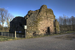
Bury Castle was an early medieval moated manor house in Bury, Lancashire. Its remains are listed as a Scheduled Ancient Monument. The manor house was built by Sir Thomas Pilkington – lord of the manors of Bury and Pilkington, and an influential member of Lancashire's gentry – in 1469. He was given permission by Edward IV to:
"'build to make and to construct walls and turrets with stone, lime and sand around and below his manor house in Bury in the County of Lancaster, and to shut in the manor house with such manner of walls and turrets; also to embattle, crenellate and machicolate those towers."

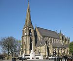
The Parish Church of St Mary, Radcliffe is a church in Radcliffe, Greater Manchester. It was built during the 14th century, but the tower was not added until the 15th century. The building is designated Grade I by English Heritage, having been listed in 1966 under its former name of the Church of St Mary and St Bartholomew. In 1991, some local parishes were merged, and the church adopted its present name.

Hinton Waldrist is a village and civil parish in the Vale of White Horse, England. It was part of Berkshire until the 1974 boundary changes transferred it to Oxfordshire. The village is between Oxford and Faringdon, 9 miles (14 km) southwest of Oxford. The parish includes the hamlet of Duxford. The 2011 Census recorded the parish's population as 328.

Kilmington is a village and civil parish in the extreme west of Wiltshire, England, about 8 miles (13 km) southwest of Warminster. The parish includes the hamlets of Kilmington Common and Norton Ferris.

St James, Norton is the Church of England parish church of the Norton district of Sheffield, South Yorkshire, England.

There are 48 Grade I listed buildings in Greater Manchester, England. In the United Kingdom, the term listed building refers to a building or other structure officially designated as being of special architectural, historical or cultural significance; Grade I structures are those considered to be "buildings of exceptional interest". In England, the authority for listing under the Planning Act 1990 rests with Historic England, a non-departmental public body sponsored by the Department for Culture, Media and Sport.
Radcliffe is a town in the Metropolitan Borough of Bury, Greater Manchester, England, and includes the village of Ainsworth and the countryside around and between them. It is unparished, and contains 31 listed buildings that are recorded in the National Heritage List for England. Of these, two are listed at Grade I, the highest of the three grades, three are at Grade II*, the middle grade, and the others are at Grade II, the lowest grade. The listed buildings include farmhouses and farm buildings, private houses, churches and associated items, a ruined pele tower, a public house, two structures associated with the demolished Mount Sion Mill, a disused railway viaduct, and a war memorial.