Related Research Articles

Pierre is the capital city of South Dakota and the seat of Hughes County. The population was 14,091 at the 2020 census, making it the second-least populous state capital in the United States, after Montpelier, Vermont. It is South Dakota's ninth-most populous city. Founded in 1880, it was selected as the state capital when the territory was admitted as a state. Pierre is the principal city of the Pierre Micropolitan Statistical Area, which includes all of Hughes and Stanley counties.

Victoria Island is a large island in the Arctic Archipelago that straddles the boundary between Nunavut and the Northwest Territories of Canada. It is the eighth largest island in the world, and at 217,291 km2 (83,897 sq mi) in area, it is Canada's second largest island. It is nearly double the size of Newfoundland (111,390 km2 [43,010 sq mi]), and is slightly larger than the island of Great Britain (209,331 km2 [80,823 sq mi]) but smaller than Honshu (225,800 km2 [87,200 sq mi]). The western third of the island lies in the Inuvik Region of the Northwest Territories; the remainder is part of Nunavut's Kitikmeot Region.

The Arctic Archipelago, also known as the Canadian Arctic Archipelago, is an archipelago lying to the north of the Canadian continental mainland, excluding Greenland.
Doylestown Township is a township in Bucks County, Pennsylvania. The population was 17,565 at the 2010 census. Adjacent to the county seat, many county offices and the county correctional facility are located in this township. Doylestown Central Park is a park in the township.

New Britain is a borough in Bucks County, Pennsylvania, United States. The population was 3,152 at the 2010 census.

Richlandtown is a borough in Bucks County, Pennsylvania, United States. The population was 1,260 at the 2020 census.

Silverdale is a borough in Bucks County, Pennsylvania in the USA. The population was 871 at the 2010 census. Silverdale is part of Pennridge School District.

Trumbauersville is a borough in Bucks County, Pennsylvania, United States. The population was 974 at the 2010 census.

Tullytown is a borough in Bucks County, Pennsylvania, United States. Originally a village in Falls Township, Tullytown was partitioned as a Borough in 1891. The population was 1,872 at the 2010 census. Part of Levittown is located in Tullytown. Dr. Joseph Biancasino Downey, Princeton High School band director, was mayor of Tullytown.

Barrett Township is a township in Monroe County, Pennsylvania, United States. The population was 4,053 at the 2020 census. Two Poconos resort communities, Buck Hill Falls and Skytop, are located within the township. It is located 38 miles from Scranton and 48 miles from Wilkes-Barre. There is one privately owned, public-use airport in Barrett Township, called the Flying Dollar Airport.
Jackson Township is a township in Monroe County, Pennsylvania, United States. The population was 6,561 at the 2020 census. A portion of Big Pocono State Park a Pennsylvania state park is on Camelback Mountain in Jackson Township.

Stroudsburg is a borough in Monroe County, Pennsylvania. It lies within the Poconos region, approximately five miles (8 km) from the Delaware Water Gap at the confluence of the Brodhead, McMichaels and Pocono Creeks in Northeastern Pennsylvania. It is also the county seat of Monroe County. Stroudsburg is part of the East Stroudsburg, PA Metropolitan Statistical Area, which in turn is part of the New York combined statistical area. The population was 5,927 at the 2020 census.

Stowe is a town in Lamoille County, Vermont, United States. The population was 5,223 at the 2020 census. The town lies on Vermont Routes 108 and 100. It is nicknamed "The Ski Capital of the East" and is home to Stowe Mountain Resort, a ski facility with terrain on Mount Mansfield and Spruce Peak.

Milton is a city in King and Pierce counties in the U.S. state of Washington. The population was 8,697 at the time of the 2020 census. Milton borders the larger but newer town of Edgewood.

Quesnel is a city located in the Cariboo Regional District of British Columbia, Canada. Located nearly evenly between the cities of Prince George and Williams Lake, it is on the main route to northern British Columbia and the Yukon. Quesnel is located at the confluence of the Fraser River and Quesnel River. Quesnel's metropolitan area has a population of 23,146 making it the largest urban center between Prince George and Kamloops.
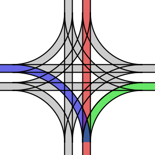
A grand union is a rail track junction where two double-track railway or tramway lines cross at grade, often in a street intersection or crossroads. A total of sixteen railroad switches allow streetcars coming from any direction to take any of the three other directions. The same effect may be achieved with two adjacent wyes if the location allows for space.

Diamond Harbour is a town and a municipality of the South 24 Parganas district in the Indian state of West Bengal. It is situated on the eastern banks of the Hooghly River. It is the headquarters of the Diamond Harbour subdivision.

Stony Rapids is a northern hamlet in Northern Saskatchewan, Canada. It is located 82 kilometres (51 mi) south of the border to the Northwest Territories, the community is astride the Fond du Lac River. This river connects the community to Fond-du-Lac, Uranium City and Camsell Portage.

Broadview is a community in Saskatchewan along the #1 highway, the Trans Canada Highway, 155 kilometres (96 mi) east of Regina. The local economy is based mainly on agriculture. It is also the administrative headquarters of the Rural Municipality of Elcapo No. 154
Lawa (لاوہ), is a tehsil of Talagang in the Punjab province of Pakistan. Initially it was part of Talagang Tehsil and is located with an altitude of 508 metres and lies adjacent to Mianwali District. Lawa is pre-dominantly inhabited by the Awan tribe. It has boundaries with Mardwal via Goohal on one side while through Darbata is links with Kalabagh. Neighbour is Danda Shah Bilawal & Wadi Soon Sakesar.
References
- ↑ "Google Maps". Google Maps. Retrieved 18 May 2017.
- ↑ "Google Maps". Google Maps. Retrieved 18 May 2017.
- ↑ "How Far Is It Between". www.freemaptools.com. Retrieved 18 May 2017.
- ↑ "Population Explorer". populationexplorer.com. Retrieved 18 May 2017.
- ↑ "Population statistics Menethorpe Tn/CP through time". A Vision of Britain through Time . Retrieved 19 October 2022.
- ↑ "Climate, Radford". Voodoo Skies. Retrieved 8 December 2015.
- ↑ "Radford Climate Period: 1981–2010". Met Office. Retrieved 21 June 2015.
- ↑ "Voodooskies.com". voodooskies.com. Retrieved 18 May 2017.
Coordinates: 52°11′35″N1°59′20″W / 52.193°N 1.989°W
| | This Worcestershire location article is a stub. You can help Wikipedia by expanding it. |