
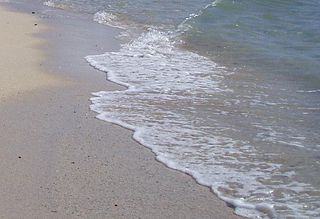
A beach is a landform alongside a body of water which consists of loose particles. The particles composing a beach are typically made from rock, such as sand, gravel, shingle, pebbles, etc. The particles can also be biological in origin, such as mollusc shells or coralline algae. Sediments settle in different densities and structures, depending on the local wave action and weather, creating different textures, colors and gradients or layers of material.

A slurry pipeline is a specially engineered pipeline used to move ores, such as coal or iron, or mining waste, called tailings, over long distances. A mixture of the ore concentrate and water, called slurry, is pumped to its destination and the water is filtered out. Due to the abrasive properties of slurry, the pipelines can be lined with high-density polyethylene (HDPE), or manufactured completely from HDPE Pipe, although this requires a very thick pipe wall. Slurry pipelines are used as an alternative to railroad transportation when mines are located in remote, inaccessible areas.

Sediment is a naturally occurring material that is broken down by processes of weathering and erosion, and is subsequently transported by the action of wind, water, or ice or by the force of gravity acting on the particles. For example, sand and silt can be carried in suspension in river water and on reaching the sea bed deposited by sedimentation. If buried, they may eventually become sandstone and siltstone through lithification.

Spray drying is a method of producing a dry powder from a liquid or slurry by rapidly drying with a hot gas. This is the preferred method of drying of many thermally-sensitive materials such as foods and pharmaceuticals. A consistent particle size distribution is a reason for spray drying some industrial products such as catalysts. Air is the heated drying medium; however, if the liquid is a flammable solvent such as ethanol or the product is oxygen-sensitive then nitrogen is used.

Coastal erosion is the loss or displacement of land, or the long-term removal of sediment and rocks along the coastline due to the action of waves, currents, tides, wind-driven water, waterborne ice, or other impacts of storms. The landward retreat of the shoreline can be measured and described over a temporal scale of tides, seasons, and other short-term cyclic processes. Coastal erosion may be caused by hydraulic action, abrasion, impact and corrosion by wind and water, and other forces, natural or unnatural.
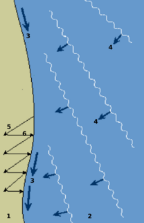
Longshore drift from longshore current is a geological process that consists of the transportation of sediments along a coast parallel to the shoreline, which is dependent on oblique incoming wave direction. Oblique incoming wind squeezes water along the coast, and so generates a water current which moves parallel to the coast. Longshore drift is simply the sediment moved by the longshore current. This current and sediment movement occur within the surf zone.

A groyne, built perpendicular to the shore, is a rigid hydraulic structure built from an ocean shore or from a bank that interrupts water flow and limits the movement of sediment. It is usually made out of wood, concrete, or stone. In the ocean, groynes create beaches, prevent beach erosion caused by longshore drift where this is the dominant process and facilitate beach nourishment. There is also often cross-shore movement which if longer than the groyne will limit its effectiveness.

Hydraulic mining is a form of mining that uses high-pressure jets of water to dislodge rock material or move sediment. In the placer mining of gold or tin, the resulting water-sediment slurry is directed through sluice boxes to remove the gold. It is also used in mining kaolin and coal.

Palm Islands are three artificial islands, Palm Jumeirah, Deira Island and Palm Jebel Ali, on the coast of Dubai, United Arab Emirates. Creation of the islands started in 2001.

Dredging is the operation of excavating material from a water environment. Possible purposes of dredging include: improving existing water features; reshaping land and water features to alter drainage, navigability, and commercial use; constructing dams, dikes, and other controls for streams and shorelines; and recovering valuable mineral deposits or marine life having commercial value. In all but a few situations the excavation is undertaken by a specialist floating plant, known as a dredger. Dredging is carried out in many different locations and for many different purposes, but the main objectives are usually to recover material of value or use, or to create a greater depth of water. Dredges have been classified as suction or mechanical.

Beach nourishment describes a process by which sediment, usually sand, lost through longshore drift or erosion is replaced from other sources. A wider beach can reduce storm damage to coastal structures by dissipating energy across the surf zone, protecting upland structures and infrastructure from storm surges, tsunamis and unusually high tides. Beach nourishment is typically part of a larger Integrated coastal zone management aimed at coastal defense. Nourishment is typically a repetitive process since it does not remove the physical forces that cause erosion but simply mitigates their effects.

Coastal geography is the study of the constantly changing region between the ocean and the land, incorporating both the physical geography and the human geography of the coast. It includes understanding coastal weathering processes, particularly wave action, sediment movement and weather, and the ways in which humans interact with the coast
Swash, or forewash in geography, is a turbulent layer of water that washes up on the beach after an incoming wave has broken. The swash action can move beach materials up and down the beach, which results in the cross-shore sediment exchange. The time-scale of swash motion varies from seconds to minutes depending on the type of beach. Greater swash generally occurs on flatter beaches. The swash motion plays the primary role in the formation of morphological features and their changes in the swash zone. The swash action also plays an important role as one of the instantaneous processes in wider coastal morphodynamics.

Siltation, or sans, is water pollution caused by particulate terrestrial clastic material, with a particle size dominated by silt or clay. It refers both to the increased concentration of suspended sediments and to the increased accumulation of fine sediments on bottoms where they are undesirable. Siltation is most often caused by soil erosion or sediment spill.
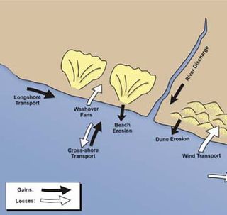
Sedimentary budgets are a coastal management tool used to analyze and describe the different sediment inputs (sources) and outputs (sinks) on the coasts, which is used to predict morphological change in any particular coastline over time. Within a coastal environment the rate of change of sediment is dependent on the amount of sediment brought into the system versus the amount of sediment that leaves the system. These inputs and outputs of sediment then equate to the total balance of the system and more than often reflect the amounts of erosion or accretion affecting the morphology of the coast.

The Atlantic surf clam, also called the bar clam, hen clam, skimmer or simply sea clam, is a very large, edible, saltwater clam or marine bivalve mollusk in the family Mactridae. It is commonly found in the western Atlantic Ocean. Reaching up to 20 centimetres (7.9 in) or more in length, it is much larger than Spisula solida, which resides in the eastern Atlantic waters off of Great Britain.

A river is a natural flowing watercourse, usually freshwater, flowing towards an ocean, sea, lake or another river. In some cases a river flows into the ground and becomes dry at the end of its course without reaching another body of water. Small rivers can be referred to using names such as stream, creek, brook, rivulet, and rill. There are no official definitions for the generic term river as applied to geographic features, although in some countries or communities a stream is defined by its size. Many names for small rivers are specific to geographic location; examples are "run" in some parts of the United States, "burn" in Scotland and northeast England, and "beck" in northern England. Sometimes a river is defined as being larger than a creek, but not always: the language is vague.

Sand is a granular material composed of finely divided rock and mineral particles. It is defined by size, being finer than gravel and coarser than silt. Sand can also refer to a textural class of soil or soil type; i.e., a soil containing more than 85 percent sand-sized particles by mass.
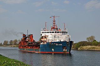
A trailing suction hopper dredger is a ship that has a full sailing capacity used to maintain navigable waterways, deepening the maritime canals that are threatened to become silted, to construct new land elsewhere or to replace sand eroded by storms or wave action on the beaches. This is made possible by large powerful pumps and engines able to suck sand, clay, silt and gravel.
A dredge plume is a cloud of debris that forms as a result of dredging. Such plumes usually begin either at the bottom where the dredging takes place, or at the surface from either overflow from the dredging equipment or dumping of the dredged material in a different location.
