
Erosion is the action of surface processes that removes soil, rock, or dissolved material from one location on the Earth's crust and then transports it to another location where it is deposited. Erosion is distinct from weathering which involves no movement. Removal of rock or soil as clastic sediment is referred to as physical or mechanical erosion; this contrasts with chemical erosion, where soil or rock material is removed from an area by dissolution. Eroded sediment or solutes may be transported just a few millimetres, or for thousands of kilometres.
Soil erosion is the denudation or wearing away of the upper layer of soil. It is a form of soil degradation. This natural process is caused by the dynamic activity of erosive agents, that is, water, ice (glaciers), snow, air (wind), plants, and animals. In accordance with these agents, erosion is sometimes divided into water erosion, glacial erosion, snow erosion, wind (aeolean) erosion, zoogenic erosion and anthropogenic erosion such as tillage erosion. Soil erosion may be a slow process that continues relatively unnoticed, or it may occur at an alarming rate causing a serious loss of topsoil. The loss of soil from farmland may be reflected in reduced crop production potential, lower surface water quality and damaged drainage networks. Soil erosion could also cause sinkholes.

A gully is a landform created by running water, mass movement, or commonly a combination of both eroding sharply into soil or other relatively erodible material, typically on a hillside or in river floodplains or terraces. Gullies resemble large ditches or small valleys, but are metres to tens of metres in depth and width and are characterised by a distinct 'headscarp' or 'headwall' and progress by headward erosion. Gullies are commonly related to intermittent or ephemeral water flow usually associated with localised intense or protracted rainfall events, or snowmelt. Gullies can be formed and accelerated by cultivation practices on hillslopes in farmland, and they can develop rapidly in rangelands from existing natural erosion forms subject to vegetative cover removal and livestock activity.
Robert Elmer Horton was an American hydrologist, geomorphologist, civil engineer, and soil scientist, considered by many to be the father of modern American hydrology. An eponymous medal is awarded by the American Geophysical Union (AGU) to recognize outstanding contributions to the field of hydrological geophysics. The AGU Hydrology section was formed largely due to his personal property that was bequeathed to AGU.
Claypan is a dense, compact, slowly permeable layer in the subsoil. It has a much higher clay content than the overlying material, from which it is separated by a sharply defined boundary. The dense structure restricts root growth and water infiltration. Therefore, a perched water table might form on top of the claypan. In the Canadian classification system, claypan is defined as a clay-enriched illuvial B (Bt) horizon.
Drainage density is a quantity used to describe physical parameters of a drainage basin. First described by Robert E. Horton, drainage density is defined as the total length of channel in a drainage basin divided by the total area, represented by the following equation:

Infiltration is the process by which water on the ground surface enters the soil. It is commonly used in both hydrology and soil sciences. The infiltration capacity is defined as the maximum rate of infiltration. It is most often measured in meters per day but can also be measured in other units of distance over time if necessary. The infiltration capacity decreases as the soil moisture content of soils surface layers increases. If the precipitation rate exceeds the infiltration rate, runoff will usually occur unless there is some physical barrier.
The United States Environmental Protection Agency (EPA) Storm Water Management Model (SWMM) is a dynamic rainfall–runoff–subsurface runoff simulation model used for single-event to long-term (continuous) simulation of the surface/subsurface hydrology quantity and quality from primarily urban/suburban areas. It can simulate the Rainfall- runoff, runoff, evaporation, infiltration and groundwater connection for roots, streets, grassed areas, rain gardens and ditches and pipes, for example. The hydrology component of SWMM operates on a collection of subcatchment areas divided into impervious and pervious areas with and without depression storage to predict runoff and pollutant loads from precipitation, evaporation and infiltration losses from each of the subcatchment. Besides, low impact development (LID) and best management practice areas on the subcatchment can be modeled to reduce the impervious and pervious runoff. The routing or hydraulics section of SWMM transports this water and possible associated water quality constituents through a system of closed pipes, open channels, storage/treatment devices, ponds, storages, pumps, orifices, weirs, outlets, outfalls and other regulators.
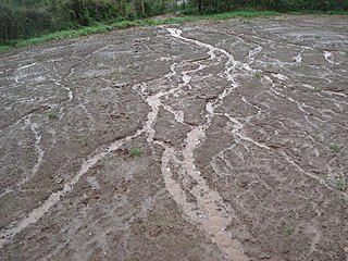
In hillslope geomorphology, a rill is a shallow channel cut into soil by the erosive action of flowing surface water. Similar but smaller incised channels are known as microrills; larger incised channels are known as gullies.

Surface runoff is the flow of water occurring on the ground surface when excess rainwater, stormwater, meltwater, or other sources, can no longer sufficiently rapidly infiltrate in the soil. This can occur when the soil is saturated by water to its full capacity, and the rain arrives more quickly than the soil can absorb it. Surface runoff often occurs because impervious areas do not allow water to soak into the ground. Furthermore, runoff can occur either through natural or man-made processes. Surface runoff is a major component of the water cycle. It is the primary agent of soil erosion by water. The land area producing runoff that drains to a common point is called a drainage basin.
Streamflow, or channel runoff, is the flow of water in streams and other channels, and is a major element of the water cycle. It is one component of the movement of water from the land to waterbodies, the other component being surface runoff. Water flowing in channels comes from surface runoff from adjacent hillslopes, from groundwater flow out of the ground, and from water discharged from pipes. The discharge of water flowing in a channel is measured using stream gauges or can be estimated by the Manning equation. The record of flow over time is called a hydrograph. Flooding occurs when the volume of water exceeds the capacity of the channel.
A spray nozzle is a device that facilitates the dispersion of a liquid by the formation of a spray. The production of a spray requires the fragmentation of liquid structures, such as liquid sheets or ligaments, into droplets, often by using kinetic energy to overcome the cost of creating additional surface area. A wide variety of spray nozzles exist, that make use of one or multiple liquid breakup mechanisms, which can be divided into three categories: liquid sheet breakup, jets and capillary waves. Spray nozzles are of great importance for many applications, where the spray nozzle is designed to have the right spray characteristics.

A buffer strip is an area of land maintained in permanent vegetation that helps to control air quality, soil quality, and water quality, along with other environmental problems, dealing primarily on land that is used in agriculture. Buffer strips trap sediment, and enhance filtration of nutrients and pesticides by slowing down surface runoff that could enter the local surface waters. The root systems of the planted vegetation in these buffers hold soil particles together which alleviate the soil of wind erosion and stabilize stream banks providing protection against substantial erosion and landslides. Farmers can also use buffer strips to square up existing crop fields to provide safety for equipment while also farming more efficiently.
The Universal Soil Loss Equation (USLE) is a widely used mathematical model that describes soil erosion processes.
The following outline is provided as an overview of and topical guide to hydrology:
The Water Erosion Prediction Project (WEPP) model is a physically based erosion simulation model built on the fundamentals of hydrology, plant science, hydraulics, and erosion mechanics. The model was developed by an interagency team of scientists to replace the Universal Soil Loss Equation (USLE) and has been widely used in the United States and the world. WEPP requires four inputs, i.e., climate, topography, soil, and management (vegetation); and provides various types of outputs, including water balance, soil detachment and deposition at points along the slope, sediment delivery, and vegetation growth. The WEPP model has been improved continuously since its public delivery in 1995, and is applicable for a variety of areas.

A spray is a dynamic collection of drops dispersed in a gas. The process of forming a spray is known as atomization. A spray nozzle is the device used to generate a spray. The two main uses of sprays are to distribute material over a cross-section and to generate liquid surface area. There are thousands of applications in which sprays allow material to be used most efficiently. The spray characteristics required must be understood in order to select the most appropriate technology, optimal device and size.
Post-fire hillslope stabilization treatments are treatments aimed at stabilizing fire-affected slopes by counteracting the negative impact of fire on vegetation and soil properties. The final objective of these treatments is reducing the risk of catastrophic runoff and erosion events and protecting valued resources downhill. Post-fire hillslope stabilization treatments are also called post-fire mitigation treatments and emergency stabilization treatments.

May Sho’ate is a river of the Nile basin. Rising in the mountains of Dogu’a Tembien in northern Ethiopia, it flows southward to empty finally in Giba and Tekezé River.
The rainfall patterns during the peak growing season of March, April and May have been changing over the past few decades in the province of Rift Valley, Kenya. Since the 1970s, rainfall during this season has increased in quantity but decreased in the number of days rained. This has resulted in an increase of rain intensity.


