Rainwater harvesting in the Sahel is a combination of "indigenous and innovative"[1] agricultural strategies that "plant the rain" and reduce evaporation, so that crops have access to soil moisture for the longest possible period of time. In the resource-poor drylands of the Sahel region of Africa, irrigation systems and chemical fertilizers are often prohibitively expensive and thus uncommon: so increasing or maintaining crop yields in the face of climate change depends on augmenting the region's extant rainfed agriculture systems to "increase water storage within the soil and replenish soil nutrients."[2]Rainwater harvesting is a form of agricultural water management.[3] Rainwater harvesting is most effective when combined with systems for soil regeneration and organic-matter management.[4]
Landscape gradient of the Sahel, photographed from space
The Sahel is an ecologically (rather than geopolitically) defined region of Africa. The noun Sahel comes from the Arabic sāḥil (Arabic: ساحل) describing a border, shore or edge, which aptly describes the transitional areas of Africa where savanna becomes the hyper-arid Sahara Desert. (According to the Concise Oxford Dictionary of World Place Names, "The Arabs considered the Sahara to be a huge ocean with the Sahel as its shore."[5]) The Sahel crosses Senegal, The Gambia, Mauritania, Mali, Burkina Faso, Ghana, Niger, Nigeria, Cameroon, Chad, Central African Republic, South Sudan, Sudan, and Eritrea in a belt up to 1,000km (620mi) wide that spans 5,400km (3,360mi) from the Atlantic Ocean in the west to the Red Sea in the east. The Sahel is marked by decreasing levels of precipitation from south to north, but what defines a dryland ecosystem is not necessarily low rainfall. In some cases the dryness is due to persistent high levels of evaporation (due to heat or desiccating winds). Unpredictable rainfall is often also a factor.[6]
Place
The Sahel
The Sahara
The Sahel
Sub-Saharan Africa
Population estimates of the Sahel vary depending on which political subdivisions are included, but the count is in the vicinity of 100 million people,[7] including nearly a million refugees and internally displaced people.[8] The countries of the Sahel region are mainly poor. For example, the Volta River basin is occupied by about 20 million people who live in the countries of Burkina Faso and Ghana; 61 percent of Burkinabe and 45 percent of Ghanaians live on less than US$1 per day.[9] About 12 million farmers in the region (including people in Niger, Chad, Mauritania, Mali, and probably Burkina Faso and Senegal[10]), are occasionally or "chronically vulnerable to food and nutrition insecurity."[11] The Brookings Institution has described Sahelians as among the "most underprivileged, marginalized, and poorest people" on Earth.[7]
Subsistence food production
Irrigation in the Sahel tends to be reserved for cash crops like groundnuts; these Nigerian women are selling okpa made from groundnuts.
Agriculture contributes between 10 and 70 percent of GDP to the economies of most sub-Saharan countries.[12] The major agricultural systems of the Sahel are oasis, pastoral, and mixed production of cereals and root crops.[13] The root crops are predominantly sweet potato and cassava; cereals are predominantly millet and sorghum, with some maize; the "north-south rainfall gradient defines...a successive north-south dominance of millet, sorghum and maize."[9]Climate changes over the next 25 years are predicted to decrease Sahelian cereal production by double-digit percentages, largely due to increased heat.[14][11] The Intergovernmental Panel on Climate Change also predicts double-digit decreases due to increased rainfall variability.[15]
Homegrown staple crops account for an estimated 90 percent of food consumption in the Sahel, and 90 percent of these crops are grown using exclusively rain-fed agriculture.[16][11] A general African transition to first-world-style irrigation systems is considered unlikely, and the Sahel region has an "especially limited irrigation potential."[17] According to the United Nations Food and Agriculture Organization, no more than 10 percent of African food production is likely to be grown under irrigation over the next 20 years.[18] Mechanized irrigation, where it exists, is typically limited to more lucrative cash crops, rather than subsistence.[19] Therefore, in order to increase or even maintain the Sahel's dryland agriculture production capacity the "most logical strategy...will be improving rainfed productivity for most staples."[18]
Freshly ground millet flour ready for millet couscous or millet porridge; millet, a staple ingredient for cuisines across the arid and semi-arid Sahelian climatic zone, goes by many local names: in Wolof, soungouf, in French, farine de mil.
Precipitation patterns and soil quality are "key constraint[s]" in Sahelian food production.[20] Rainfall levels are both generally low to start with and "highly variable" to complicate matters.[21] This variability is a common cause of crop failure due to unpredictable "onset and distribution" of rainfall;[9] cereal yields are impacted by the start date and duration of the rain as much as by the absolute quantity.[15] The majority of the year is the dry season, which ends with harmattan winds blowing dust south from the Sahara; rain usually falls between one and four months of the year, from June through September.[22][23]
Soils in the Sahel are typically degraded, [21] often "crusty, abandoned agricultural lands"[24] and "particularly poor in organic carbon."[25] In Burkina Faso, one-third of all land is degraded.[26] The human-induced structural damage to soils[27] wrought by intensive 20th-century agriculture methods "is especially evident during droughts when the land is stripped bare of vegetation and erosive winds and water take their toll."[28] In addition to the toll of soil and wind erosion on old fields, the practices of burning or removing crop residues, and a shift to fewer or no fallowing periods due to increased population density (and commensurate increased need to cultivate all accessible land) have contributed to further decreases in natural fertility. [29][30]
The Sahel is dappled with "unproductive crusty patches" found on "old dunes, sandy plains, colluvial slopes, and alluvial terraces."[29] These "glazed" patches are regionally known as glacis and are found, for example, on approximately 60 percent of all degraded land in Niger.[31] "Glacis" describes a slope made particularly slippery, for whatever reason, and is related to the Old Frenchglacier.[32]Glacis patches in the Sahel are more or less impermeable; rainwater runs off or evaporates, further immiserating the soil biome, and thus the plants and the people.[31]
Even before the full impact of climate change is felt in the Sahel, the region struggles with challenges including "unsustainable management strategies, weak economies, weak infrastructure, 'inappropriate resource tenure', inappropriate interventions (such as eucalyptus plantations), [and] ineffective institutions."[33] The future of the Sahel is insecure.[34] Climate change impacts will be variable but there is a "likelihood of negative impacts in most locations from increased temperatures, greater rainfall variability, and more extreme weather events."[35]
In South Sudan, a mother harvests the root crop cassava while her daughter collects firewood.
Rainwater harvesting techniques of the Sahel
The purpose of rainwater harvesting in the Sahel and other dryland eco-agricultural regions is to extend the usability of irregular water inputs.[25] Banking rainwater (through techniques often summarized by the epigram "slow it, spread it, sink it") is possible with site-appropriate techniques and as more water becomes "available for ecosystems...their capacity to perform their functions is improved."[36] Furthermore, soil restoration is possible and would potentially open up more than 700,000,000 acres (280,000,000ha) of land in Africa for additional cultivation, which could in turn reduce deforestation for agricultural uses.[26] Niger has implemented several of these techniques on a wide scale beginning in the 1980s and has recovered approximately 250,000ha (620,000 acres) of degraded land.[37]
Benefits of rainwater harvesting (especially on a community scale) include additional drinking water for animals, land reclamation opportunities, higher soil fertility, accelerated growth of timber for firewood, and reinforcement of a virtuous cycle pattern leading toward additional rainfall[12] (trees make rain).[38] Any or all of the following techniques reduce water runoff and thus increase soil water storage, generally yielding about two to three times more growth than crops grown in the same regions/conditions under a more conventional system.[39] One study found that appropriately managed Sahelian rainwater-harvesting techniques increased runoff retention up to 87 percent, doubled water infiltration rates, and extended the crop-growing season up to 20 days.[40]
A bouli[fr] is a small-scale artificial pond dug "where there is convergence of runoff" at the midpoint or bottom of a slope. This water tends to last for two[41] or even three months into the dry period after the monsoon.[42][43] In addition to supplying additional water for livestock and vegetable gardens the bouli "can recreate an ecosystem favourable to the life of the fauna and the local flora, boosting recharge of water tables during droughts and allowing vegetation to grow even during the dry period."[44]Bouli may be the most poorly studied of the rainwater harvesting techniques appropriate for the Sahel, as there are relatively few studies about the mechanics and benefits of this system.[44]
Bunds
Barrier to slow down the advance of sand dunes in the outskirts of Chinguetti, Adrar, Mauritania
Mauritian farmers build weirs to trap windblown sand during the dry season and during the "infrequent rains" these weirs serve to minimize water runoff and maximize groundwater recharge; the stone rows of Burkina Faso, Mali, and Niger function by similar principles.[45] Stone rows, typically called bunds, are a traditional and widely used means of land improvement in the Sahel. Laid out on contour, stone rows minimize soil erosion but also minimize rainwater runoff and offer favorable microclimates.[46][1][42] Bunds not laid out in parallel with the natural contours of the land may result in "some gully formation during rainy periods."[47] Bunds can also be made of earth, which was the original practice that preceded the use of stone.[46] Bunds may be laid out up to 30 meters apart and may themselves be planted with indigenous vegetation such as Andropogon gayanus or Piliostigma reticulatum.[46]
Both earth and stone bunds are prone to material deterioration over time and demand periodic maintenance; as a general rule, the more stones used the more stable the row.[46][44]Projet d’aménagement des terroirs et conservation des eaux (PATECORE) popularized the three-stone system for building more durable, animal-disturbance-resistant stone rows, in which one large stone is placed atop three smaller stones.[48][49][50]
Stone bunds and demi-lunes constructed on a farm in Ethiopia
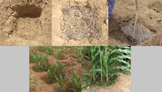
Half-moons, which are known as demi-lunes[fr] through much of the Sahel because of the French colonial influence on regional languages, are a widely used traditional form of semi-circular planting pit. Half-moons are formed by digging a hole up to four meters across but somewhat shallower in depth,[51] and "placing the removed earth on the downhill side." [42] Half-moons are particularly useful for remediating the more or less impermeable glacis soils.[31] These edged planting pits capture and hold organic matter and moisture. The accumulated detritus in turn attracts termites and other invertebrates whose actions create passages and pores in the organic matter, building humus, and permitting better water infiltration.[1][26] Half-moons have been shown to reduce the risk of crop failure and increase agricultural productivity, especially with the use of "complementary inputs" such as animal manures.[52]
Half-moons, however, are extremely labor-intensive: "constructing just one takes several hours"[30] and the preparation of the planting areas must be done during the dry season when the ground is very hard and the heat may be severe. According to one account based on interviews with Sahelian farm families, "preparation of [one hectare of demi-lunes] amounts to two to four person-months of work, and yearly maintenance of approximately one-person month is required."[1]
A zaï is a "water pocket"[42] and is another indigenous planting method, developed in the Yatenga.[53] The word comes from the Moré language, and means something like "getting up early and hurrying out to prepare the soil" or even "breaking and fragmenting the soil crust before sowing."[15]Tassa is the Hausa language word for this concept.[54] A similar practice in the Yako region is called guendo.[55] Similar to half-moons, but smaller, zaï are usually 24 to 40cm wide, 10 to 25cm deep, spaced about 40cm apart in a grid across the field. Zaï are usually established with "two handfuls" of organic matter in the form of animal manure, crop residues, or a composted combination of the two.[44] These pits were traditionally used on a small scale to remediate degraded zipélé lands but are now being used on much larger plots.[47]Zaï are best-suited for use in areas that see "isohyets of 300 and 800 mm rainfall."[56]Zaï have been shows to increase yields between 2.5 and 20 times normal, "depending on the crop."[57]
As with half-moons, the major drawback of zaï is in the hundreds of man-hours that are necessary to build them.[58] Families must either have a large number of fit and able-bodied workers, or "pay for the services of the young people's association."[59]
Other techniques
Other beneficial and successful practices in the Sahel include:
Tied ridges, a planting system that looks a Belgian waffle[46]
Obstacles to implementation
Dried cow dung near Katari, Nigeria; in some cases a shortage of nitrogen-rich animal manures is a limiting factor on establishing zaï and demi-lunesLandscape of Mopti Region, Mali, in 1972, a period of severe Sahel drought
Widespread adoption of rainwater harvesting techniques in the Sahel is so far limited by a number of factors including a high upfront cost for labor.[62][63] The massive quantity and weight of stones needed to establish bunds is often prohibitive.[64] It is estimated that 40 long tons (41,000kg; 90,000lb) of rock are needed to establish stone rows for just one hectare of arable land.[61] Other limits include lack of knowledge about these techniques and the absence of training programs.[12]
In the words of one development analyst, "agricultural water management strategies have been over-studied, over-promoted, and over-funded. However, despite the efforts of numerous projects, water scarcity still limits agricultural production of most of the smallholder crop-livestock farmers of the basin and cereal yields are still lying far below their potential."[65] One study found that village training programs, "a low-cost policy intervention," were highly effective in increasing uptake of rainwater harvesting techniques.[66][67]
Additional images
Rainwater harvesting in the Sahel
Annual rainfall in the Sahel
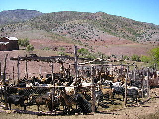
Example of an arid pastoral-oasis agricultural system in Fada, Chad
Fox, P.; Rockström, J. (2000). "Water-harvesting for supplementary irrigation of cereal crops to overcome intra-seasonal dry-spells in the Sahel". Physics and Chemistry of the Earth, Part B: Hydrology, Oceans and Atmosphere. 25 (3): 289–296. Bibcode:2000PCEB...25..289F. doi:10.1016/S1464-1909(00)00017-4.
Burkina Faso is a landlocked Sahel country that shares borders with six nations. It lies between the Sahara desert and the Gulf of Guinea, south of the loop of the Niger River, mostly between latitudes 9° and 15°N, and longitudes 6°W and 3°E. The land is green in the south, with forests and fruit trees, and semi-arid in the north. Most of central Burkina Faso lies on a savanna plateau, 198–305 metres (650–1,001 ft) above sea level, with fields, brush, and scattered trees. Burkina Faso's game preserves – the most important of which are Arly, Nazinga, and W National Park—contain lions, elephants, hippopotamus, monkeys, common warthogs, and antelopes. Previously the endangered painted hunting dog, Lycaon pictus occurred in Burkina Faso, but, although the last sightings were made in Arli National Park, the species is considered extirpated from Burkina Faso.
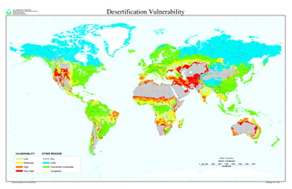
Desertification is a type of land degradation in drylands in which biological productivity is lost due to natural processes or induced by human activities whereby fertile areas become arid. It is the spread of arid areas caused by a variety of factors, such as overexploitation of soil as a result of human activity and the effects of climate change. Geographic areas most affected include the Sahel region in Africa, the Gobi Desert and Mongolia in Asia as well as parts of South America. Drylands occupy approximately 40–41% of Earth's land area and are home to more than 2 billion people.
The Sahel region or Sahelian acacia savanna is a biogeographical region in Africa. It is the transition zone between the more humid Sudanian savannas to its south and the drier Sahara to the north. The Sahel has a hot semi-arid climate and stretches across the southernmost latitudes of North Africa between the Atlantic Ocean and the Red Sea. Although geographically located in the tropics, the Sahel does not have a tropical climate.
Dryland farming and dry farming encompass specific agricultural techniques for the non-irrigated cultivation of crops. Dryland farming is associated with drylands, areas characterized by a cool wet season followed by a warm dry season. They are also associated with arid conditions, areas prone to drought and those having scarce water resources.
Rainwater harvesting (RWH) is the collection and storage of rain, rather than allowing it to run off. Rainwater is collected from a roof like surface and redirected to a tank, cistern, deep pit, aquifer, or a reservoir with percolation, so that it seeps down and restores the ground water. Dew and fog can also be collected with nets or other tools. Rainwater harvesting differs from stormwater harvesting as the runoff is typically collected from roofs and other area surfaces for storage and subsequent reuse. Its uses include watering gardens, livestock, irrigation, domestic use with proper treatment, and domestic heating. The harvested water can also be committed to longer-term storage or groundwater recharge.
Contour bunding or contour farming or Contour ploughing is the farming practice of plowing and/or planting across a slope following its elevation contour lines. These contour lines create a water break which reduces the formation of rills and gullies during times of heavy precipitation, allowing more time for the water to settle into the soil. In contour plowing, the ruts made by the plow run perpendicular rather than parallel to the slopes, generally furrows that curve around the land and are level. This method is also known for preventing tillage erosion. Tillage erosion is the soil movement and erosion by tilling a given plot of land. A similar practice is contour bunding where stones are placed around the contours of slopes. Contour ploughing has been proved to reduce fertilizer loss, power and time consumption, and wear on machines, as well as to increase crop yields and reduces soil erosion.
The Sahel region of Africa has long experienced a series of historic droughts, dating back to at least the 17th century. The Sahel region is a climate zone sandwiched between the Sudanian Savanna to the south and the Sahara desert to the north, across West and Central Africa. While the frequency of drought in the region is thought to have increased from the end of the 19th century, three long droughts have had dramatic environmental and societal effects upon the Sahel nations. Famine followed severe droughts in the 1910s, the 1940s, and the 1960s, 1970s and 1980s, although a partial recovery occurred from 1975-80. The most recent drought occurred in 2012.
Desert farming is the practice of developing agriculture in deserts. As agriculture depends upon irrigation and water supply, farming in arid regions where water is scarce is a challenge. However, desert farming has been practiced by humans for thousands of years. In the Negev, there is evidence to suggest agriculture as far back as 5000 BC. Today, the Imperial Valley in southern California, Australia, Saudi Arabia, Israel and Palestine are examples of modern desert agriculture. Water efficiency has been important to the growth of desert agriculture. Water reuse, desalination, and drip irrigation are all modern ways that regions and countries have expanded their agriculture despite being in an arid climate.
The Great Green Wall or Great Green Wall of the Sahara and the Sahel is a project adopted by the African Union in 2007, initially conceived as a way to combat desertification in the Sahel region and hold back expansion of the Sahara desert, by planting a wall of trees stretching across the entire Sahel from Djibouti, Djibouti to Dakar, Senegal. The original dimensions of the "wall" were to be 15 km wide and 7,775 km long, but the program expanded to encompass nations in both northern and western Africa. The concept evolved into promoting water harvesting techniques, greenery protection and improving indigenous land use techniques, aimed at creating a mosaic of green and productive landscapes across North Africa. Later it adopted the view that desert boundaries change based on rainfall variations.
Farmer-managed natural regeneration (FMNR) is a low-cost, sustainable land restoration technique used to combat poverty and hunger amongst poor subsistence farmers in developing countries by increasing food and timber production, and resilience to climate extremes. It involves the systematic regeneration and management of trees and shrubs from tree stumps, roots and seeds. FMNR was developed by the Australian agricultural economist Tony Rinaudo in the 1980s in West Africa. The background and development are described in Rinaudo's book The Forest Underground.
Burkina Faso is largely wild bush country with a mixture of grass and small trees in varying proportions. The savanna region is mainly grassland in the rainy season and semi desert during the harmattan period. Fauna, one of the most diverse in West Africa, includes the elephant, hippopotamus, buffalo, monkey, lions, crocodile, giraffe, various types of antelope, and a vast variety of bird and insect life. The country has 147 mammal species, 330 aquatic species including 121 species of fish and 2067 different plant species. Of the plant species, the dominant endemic species are shea tree and the baobab, the former plant species has immense economic value to the country.
Agriculture is the primary economic activity of a majority of Niger's 17 million citizens.
Yacouba Sawadogo was a Burkinabé farmer and agronomist who successfully used a traditional farming technique called zaï to restore soils damaged by desertification and drought. Such techniques are known by the collective terms agroforestry and farmer-managed natural regeneration.
A large-scale, drought-induced famine occurred in Africa's Sahel region and many parts of the neighbouring Sénégal River Area from February to August 2010. It is one of many famines to have hit the region in recent times.
Drylands are defined by a scarcity of water. Drylands are zones where precipitation is balanced by evaporation from surfaces and by transpiration by plants (evapotranspiration). The United Nations Environment Program defines drylands as tropical and temperate areas with an aridity index of less than 0.65. One can classify drylands into four sub-types:
Zaï or tassa is a farming technique of digging pits in less permeable soil to catch water and concentrate compost. The pits are between 15 and 50 centimetres across and around 5 to 15 centimetres deep, spaced approximately 80 centimetres (3 ft) apart. The technique is traditionally used in western Sahel to restore degraded drylands and increase soil fertility.
Melesse Temesgen is an Ethiopian agricultural engineer, hydrologist and businessman. He was born on 7 July 1964 in Gojjam, Ethiopia. He is the CEO of Aybar Engineering PLC.
A number of movements seek to expand the practice of agroecology in West Africa. Agroecology is a scientific discipline, movement and practice that integrates ecology in agriculture with strong emphasis on diversification, food sovereignty, energy efficiency and sustainability. Agroecological practices apply the systems and knowledge that traditional farmers in the region have developed and inherited. The agroecological social movement empowers smallholder farmers that hold the knowledge of indigenous farming systems, however are recently engulfed by larger farms or are migrating to urban areas, looking for better paying jobs.
Desertification in Africa is a form of land degradation that involves the conversion of productive land into desert or arid areas. This issue is a pressing environmental concern that poses a significant threat to the livelihoods of millions of people in Africa who depend on the land for subsistence. Geographical and environmental studies have recently coined the term desertification. Desertification is the process by which a piece of land becomes a desert, as the word desert implies. The loss or destruction of the biological potential of the land is referred to as desertification. It reduces or eliminates the potential for plant and animal production on the land and is a component of the widespread ecosystem degradation. Additionally, the term desertification is specifically used to describe the deterioration of the world's drylands, or its arid, semi-arid, and sub-humid climates. These regions may be far from the so-called natural or climatic deserts, but they still experience irregular water stress due to their low and variable rainfall. They are especially susceptible to damage from excessive human land use pressure. The causes of desertification are a combination of natural and human factors, with climate change exacerbating the problem. Despite this, there is a common misconception that desertification in Africa is solely the result of natural causes like climate change and soil erosion. In reality, human activities like deforestation, overgrazing, and unsustainable agricultural practices contribute significantly to the issue. Another misconception is that, desertification is irreversible, and that degraded land will forever remain barren wastelands. However, it is possible to restore degraded land through sustainable land management practices like reforestation and soil conservation. A 10.3 million km2 area, or 34.2% of the continent's surface, is at risk of desertification. If the deserts are taken into account, the affected and potentially affected area is roughly 16.5 million km2 or 54.6% of all of Africa. 5.7 percent of the continent's surface is made up of very severe regions, 16.2 percent by severe regions, and 12.3 percent by moderate to mild regions.
A semi-circular bund is a rainwater harvesting technique consisting in digging semilunar holes in the ground with the opening perpendicular to the flow of water.
This page is based on this Wikipedia article Text is available under the CC BY-SA 4.0 license; additional terms may apply. Images, videos and audio are available under their respective licenses.


 Annual rainfall in the Sahel
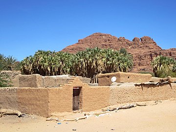 Example of an arid pastoral-oasis agricultural system in Fada, Chad
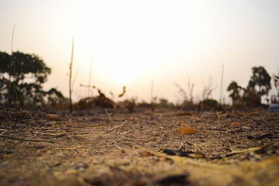 View of the horizon with the harmattan coming on
 "Dawadawa Tree in Clean and Beautiful Environment," Ghana
![Planting pits, Niouma [fr] near Yako, Passore Province, Burkina Faso Demi-lune (half-moone) agriculture.jpg](http://upload.wikimedia.org/wikipedia/commons/thumb/9/96/Demi-lune_%28half-moone%29_agriculture.jpg/220px-Demi-lune_%28half-moone%29_agriculture.jpg)