Related Research Articles

Gambier Terrace is a street of 19th-century houses overlooking St. James's Mount and Gardens and Liverpool Cathedral. It is generally reckoned to be in Canning, although it falls within the Rodney Street conservation area, together with Hope Street and Rodney Street.

St Philip Neri Church Liverpool is home to the Roman Catholic chaplaincy to the universities in Liverpool. It features a Byzantine inspired design by PS Gilby and was built between 1914 and 1920. There are exterior friezes depicting the Last Supper and of Our Lady and the Child Jesus inscribed with the two titles given to Our Lady at the Council of Ephesus in 431 AD, i.e. 'Deipara' and 'Theotokos' over the door onto Catherine Street. There is also a large stone inscribed in Latin set in the wall bearing the name of Thomas (Whiteside), Archbishop of Liverpool 8 Oct 1916 which dates from the time the church was constructed. The parish grew from the school named 'The Institute' which opened in 1853 in nearby Hope Street. It was visited by the founder of the English Oratorians (Cardinal) John Henry Newman of The Oratory of St Philip Neri in Edgbaston, Birmingham. The parish and later the church were named after Saint Philip Neri in honour of Newman since Philip Neri had founded the original Oratory church in Rome. Parish registers of the church dating as far back as 1864 can be inspected at the Liverpool Record Office.

Stanley Park is a 110 acres (45 ha) park in Liverpool, England, designed by Edward Kemp, which was opened on 14 May 1870 by the Mayor of Liverpool, Joseph Hubback. It is significant among Liverpool's parks on account of its layout and architecture. It has a grand terrace with expansive bedding schemes that were once highlighted by fountains. It includes the 1899 Gladstone Conservatory, a Grade II listed building built by Mackenzie & Moncur of Edinburgh. 50–60% of the land consisted of open turfed areas, suitable for sport, with most of the rest being laid out as formal gardens and lakes. Kemp designed a horse-riding track, though it did not catch on and was restyled as a cycle track around 1907.

Greenbank Park is a public park in Liverpool, England, with the middle of the park dominated by a small lake. It is situated in the suburb of Mossley Hill in the south of the city, close to Penny Lane and Sefton Park.

St John's Gardens is an open space in Liverpool, England, to the west of St George's Hall. The gardens are part of the William Brown Street conservation area, and comprise one of the two open spaces within Liverpool's World Heritage Site. It has been a Green Flag site since 2003. The gardens contain ornamental flower beds, and memorials to notable people of the city.

Ness Botanic Gardens are near the cities of Liverpool and Chester on the English-Welsh border in The Wirral. They occupy a site of 64 acres overlooking the Dee Estuary. The Ness Botanic Gardens were created by Arthur Kilpin Bulley (1861-1942), a wealthy cotton trader from Liverpool and benefited from collections by many garden hunters including George Forrest and Frank Kingdon-Ward.
Gladstone Dock was a station on the Liverpool Overhead Railway, between Alexandra Dock and Seaforth Sands. It was opened on 16 June 1930, the final station to open on the network.

Otterspool Promenade is a riverside walk and accompanying area of parkland in the Aigburth and Grassendale districts of Liverpool, England. The promenade runs along the bank of the River Mersey from just north of Garston Docks to Otterspool Park. A narrower footpath and cycling lane continue along the riverbank to the city centre, ending at the Albert Dock. The promenade adjoins the former private parkland estates of Cressington Park, Fulwood Park and Grassendale Park. It is notable for the excellent views it gives of shipping in the Mersey and over the river to the Wirral.
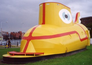
The Yellow Submarine in Liverpool is a large model representation of the submarine featured in the 1968 animated film Yellow Submarine, inspired by the 1966 song of the same name on the Beatles album Revolver. It was built by a group of about 80 apprentices from Cammell Laird's shipyard, designed in part by Mr L Pinch, a draughtsman at the yard, for exhibition at the International Garden Festival in Liverpool in 1984. The Submarine was in a garden themed around the Beatles, one of 60 such themed gardens, and was highly popular. The garden took the form of an apple-shaped labyrinth, containing symbolic references to the group, and included a bronze statue of John Lennon, which now stands at Liverpool John Lennon Airport.
Chavasse Park is an open space in the city centre of Liverpool, England, United Kingdom. It was named in commemoration of the Chavasse family; Francis and his twin sons Christopher Maude Chavasse, and Noel Godfrey Chavasse.

Woolton Woods and Camp Hill is a wooded park in the Woolton suburb of Liverpool, England.
Canning railway station was a railway station on the Liverpool Overhead Railway.

Abercromby Square is a square in the University of Liverpool, England. It is bordered by Oxford Street to the north and Cambridge Street to the south. It is named after General Sir Ralph Abercromby, commander of the British Army in Egypt, who died of his wounds following the Battle of Alexandria in 1801.
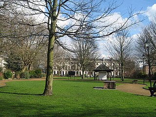
Falkner Square is a square in Canning on the border of Liverpool city centre and Toxteth. Falkner Square Gardens occupy the centre of the square. The Square was completed in 1830 and in 1835 the central area was acquired as a park, one of the first areas so acquired by the council.
Reynolds Park is a 14-acre (57,000 m2) park in Woolton, Liverpool. The origins of the park are 200 years ago, it was bequeathed to the City Council in 1926.
Devonfield Garden is a park in north Liverpool, England. In 2010, it was one of 17 parks in the city to win a Green Flag Award.
Allerton Tower Park is a public park in Allerton, Liverpool, in England.
Molunkus Stream is a tributary of the Mattawamkeag River in Maine. From the confluence of the stream's East Branch and West Branch in Sherman, the river runs 35.6 miles (57.3 km) southeast to its mouth on the Mattawamkeag in Kingman.

Grant Gardens previously Liverpool Necropolis, is a park and former cemetery in Liverpool, United Kingdom. It is named after Alderman J. R. Grant, J.P, chairman of the Corporation Parks and Gardens Committee.

NGC 4055 is an elliptical galaxy located 310 million light-years away in the constellation Coma Berenices. It was discovered by astronomer William Herschel on April 27, 1785. It was rediscovered by John Herschel on April 29, 1832. It is listed both as NGC 4061 and NGC 4055. NGC 4055 is a member of the NGC 4065 Group and forms an interacting pair with its companion, NGC 4065 as evidenced by distortions in their optical isophotes.
References
- ↑ Layton-Jones, Katy; Lee, Robert (2008), Places of Health and Amusement, Swindon: English Heritage, pp. 4–6, ISBN 978-1-873592-91-5