
The Merrick, or simply Merrick, is a mountain in the Range of the Awful Hand, a sub-range of the Galloway Hills range, part of the Southern Uplands of Scotland. The summit elevation is 843 metres, making it the highest mountain in the Southern Uplands and southern Scotland.

The Southern Uplands are the southernmost and least populous of mainland Scotland's three major geographic areas. The term is used both to describe the geographical region and to collectively denote the various ranges of hills and mountains within this region. An overwhelmingly rural and agricultural region, the Southern Uplands are partly forested and contain many areas of open moorland - the hill names in the area are congruent with these characteristics.

Scotland is the most mountainous country in the United Kingdom. Scotland's mountain ranges can be divided in a roughly north to south direction into: the Scottish Highlands, the Central Belt and the Southern Uplands, the latter two primarily belonging to the Scottish Lowlands. The highlands eponymously contains the country's main mountain ranges, but many hills and mountains are to be found south of these as well. The below lists are not exhaustive; there are countless subranges throughout the country.

The Galloway Hills are part of the Southern Uplands of Scotland, and form the northern boundary of western Galloway. They lie within the bounds of the Galloway Forest Park, an area of some 300 square miles (800 km2) of largely uninhabited wild land, managed by Forestry and Land Scotland. The unusual place names reflect a mixture of the Old Norse and Scottish Gaelic languages and hint at the range of influences which have acted on society within the area over the centuries.

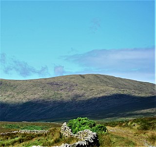
Cairnsmore of Fleet is an isolated mountain in the Southern Uplands of Scotland. The mountain forms an unafforested granite massif, whose highest point is about 10 kilometres (6.2 mi) east of Newton Stewart. It is the highest of the "Solway Hills" sub-range, and the southernmost of Scotland's 219 Grahams, thus making it, or rather its subsidiary top, Knee of Cairnsmore, the most southerly mountain in Scotland. The view to the south takes in the Cree Estuary and Wigtown Bay, and extends as far as the Lake District, the Isle of Man and Snowdonia. The highest summits of the Galloway Hills can be seen to the north, and Ireland is in the view to the west.

Cairnsmore of Carsphairn is a hill in the Carsphairn and Scaur Hills range, part of the Southern Uplands of Scotland. An alternative name, rarely used nowadays, is Cairnsmore of Deugh. It is the highest hill in the range, and its summit is just under six kilometres northeast of Carsphairn village as the crow flies, in the far north of Kirkcudbrightshire.

Kirriereoch Hill is a hill in the Range of the Awful Hand, a sub-range of the Galloway Hills range, part of the Southern Uplands of Scotland. It lies on the border of the old counties of Ayrshire and Kirkcudbrightshire, or the modern regions of Dumfries and Galloway and South Ayrshire. A boundary wall near the summit is the highest point in South Ayrshire and Ayrshire as a whole. Kirriereoch Hill was classified as a Corbett and Marilyn but then deleted from these lists in 1984 due to not being thought to achieve the respective prominence criteria. In August 2015 the hill was relisted as a Marilyn after having been surveyed to have a 150.2 m prominence. However, since this is less than the 152.4 m required, the hill will not be re-listed as a Corbett.
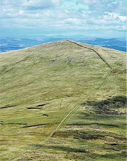
Shalloch on Minnoch is a hill in the Range of the Awful Hand, a sub-range of the Galloway Hills range, part of the Southern Uplands of Scotland. It is frequently climbed from Stinchar bridge to the north, or as part of a full traverse of the range.

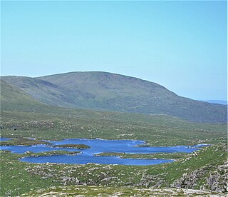
Mullwharchar is a hill in the Dungeon Hills, a sub-range of the Galloway Hills range, part of the Southern Uplands of Scotland. Mullwarchar is situated to the north of Loch Enoch, west of Corserine, northeast of Merrick and east of Kirriereoch Hill. There are 3 cliffs on the mountain named The Slock, The Tauchers and The Organ Pipes and some routes on these are occasionally climbed. Mullwharchar's summit is fairly flat and dotted with erratics.

Milldown is a hill in the Rhinns of Kells, a sub-range of the Galloway Hills range, part of the Southern Uplands of Scotland. It is located immediately north of Meikle Millyea - between these two hills lie the Lochans of Auchniebut, a series of small water bodies at an approximate elevation of 650m - possibly the highest permanent water bodies in the Southern Uplands. As well as this, the hill is also flanked on its SW side by forest plantation - possibly the highest planted commercial forestry in the Southern Uplands. Like most of its neighbours, it is most easily climbed from the east at Forrest Lodge.

Tarfessock is a hill in the Range of the Awful Hand, a sub-range of the Galloway Hills range, part of the Southern Uplands of Scotland. A craggy hill, it is the lowest Donald in the range, being completely obscured by Kirriereoch Hill when viewed from the Merrick. A nearby south top is dotted with a series of lochans. A farmhouse of the same name is located to the west, which along with the hill was at one time the property of the Marquess of Ailsa.

Meaul is a hill in the Rhinns of Kells, a sub-range of the Galloway Hills range, part of the Southern Uplands of Scotland. It is climbed from a number of directions; most commonly from Garryhorn near Carsphairn, often as part of a complete traverse of the ridge.
Cairnsgarroch is a hill in the Rhinns of Kells, a sub-range of the Galloway Hills range, part of the Southern Uplands of Scotland. Really one of approximately six satellites of the main ridge, it is usually climbed as a detour. Ascents starting from Garryhorn or Forrest Estate near Carsphairn are the most common, often as part of a complete traverse of the ridge.

Alhang is a hill in the Carsphairn and Scaur Hills range, part of the Southern Uplands of Scotland. It is the lowest Donald hill in the range; Meikledodd Hill is 1m higher. The northern slopes of the hill are the source of the River Afton. It is most easily climbed from the Water of Ken to the east or as a round from Glen Afton to the north.
Coran of Portmark is a hill in the Rhinns of Kells, a sub-range of the Galloway Hills range, part of the Southern Uplands of Scotland. The most northerly Donald of the range, it is climbed from a number of directions; most commonly from Garryhorn near Carsphairn, often the first hill of a full traverse of the ridge. An old settlement to the west lends its name to the hill.
The Dungeon Hills are a range of hills in the Galloway Hills range, part of the Southern Uplands of Scotland. The central of three parallel ridges, they are neighboured by the Range of the Awful Hand to the west and the Rhinns of Kells to the east. The range is also perpendicular to the Minnigaff Hills range, immediately south. In total, these four ranges are part of the Galloway Forest Park.

The Rhinns of Kells are a range of hills in the Galloway Hills range, part of the Southern Uplands of Scotland. The most easterly of three parallel ridges, they are neighboured to the west by the Range of the Awful Hand and the Dungeon Hills. The eastern portion of the Minnigaff Hills range lies immediately southwest of the range. In total, these four ranges are part of the Galloway Forest Park. The ridge is located entirely within Dumfries and Galloway, with the base of the western flanks being a northwestern boundary of the county.
The Minnigaff Hills are a range of hills in the Galloway Hills range, part of the Southern Uplands of Scotland. A southerly range, they are perpendicular to the Range of the Awful Hand, Dungeon Hills and Rhinns of Kells to the north. In total, these four ranges are part of the Galloway Forest Park.

The Culter Hills, Coulter Fells or variations thereof, are a range of hills, part of the Southern Uplands of Scotland. They are neighboured to the east by the Manor Hills and are split roughly in half by the border between South Lanarkshire and the Scottish Borders.

The Ettrick Hills are a range of hills, part of the Southern Uplands of Scotland. They are neighboured to the northwest by the Moffat Hills and are located mainly within the Scottish Borders, however the Dumfries and Galloway border covers the south and southwesterly flanks.

