Rapidan Dam Canal of the Rappahannock Navigation

Last updated

Rapidan Dam Canal of the Fredericksburg Navigation
USA Virginia location map.svg
Red pog.svg
Usa edcp location map.svg
Red pog.svg
Location Spotsylvania County, Virginia
Nearest city Fredericksburg, Virginia
Coordinates 38°21′28″N77°36′40″W / 38.35778°N 77.61111°W / 38.35778; -77.61111 Coordinates: 38°21′28″N77°36′40″W / 38.35778°N 77.61111°W / 38.35778; -77.61111
Built1829, rebuilt 1845
ArchitectJohn Couty
NRHP reference No. 73002063
VLR No.088-0137
Significant dates
Added to NRHPJuly 26, 1973
Designated VLRJune 19, 1973 [1]

The Rapidan Dam Canal of the Rappahannock Navigation is a canal intended to safely carry Batteaus, sturdy flat-bottomed boats used primarily for transporting cargo, around the rapids at the confluence of the Rappahannock and Rapidan Rivers. The Rapidan Canal, funded and constructed by The Rappahannock Company, consists of two different canals (the Old Rapidan Canal and the Rapidan Canal) built at different times. All of the Rappahannock Navigation, of which the Rapidan Canal is a part, is located in the Piedmont region of Virginia. The Confluence, the name used on maps of the day and sometimes maps of today to denote where the two rivers meet, is located where the borders of the Virginia Counties of Spotsylvania, Stafford and Culpeper meet but is owned by the City of Fredericksburg, Virginia. [2] The Rapidan Canal was listed on the Virginia Landmarks Register (VLR) on June 19, 1973, and on the National Register of Historic Places on July 26, 1973. [3]

Contents

History

Construction of the original Rapidan Canal, sometimes referred to as the "Old Rapidan Canal," started on the north bank of the Rappahannock River in the 1830s, fell into disrepair during the mid- and late 1830s and was abandoned entirely in the 1840s when construction of the new canal on the south bank was complete and the new canal serviceable. [4]

The Rappahannock Company

The history of the entire Rappahannock Navigation, of which the Rapidan Canal was a part, is really the story of the Rappahannock Company. Organized in 1816, The Rappahannock Company sought to build a navigable, 50-mile system of dams and locks on the Rappahannock River and the lower part of the Rapidan River to facilitate the movement of commercial goods between Fredericksburg and the furthest reaches of the navigation. Early investors were primarily Fredericksburg merchants and the Common Council of the Corporation of Fredericksburg (City of Fredericksburg) who wanted Fredericksburg's port to compete as a major shipping port. However, potential canal users on the upper reaches of the planned navigation were reluctant to invest or otherwise support the Company unless work had started on a stretch of canal that would serve their immediate interests. [5]

The Rappahannock Company had started plans for the Rappahannock Navigation as early as 1816, "...but a national recession and the promoter's inability to raise funds delayed actual construction until early 1829" [6] and only ten miles of the originally planned navigation were completed before the project was abandoned. [7] However, beginning in 1845, the Rappahannock Company restarted the effort. Existing components of the Rappahannock Navigation, deteriorated from poor or nonexistent maintenance and damaged by floods and ice, [5] were rebuilt or abandoned and the remainder of the originally planned 50-mile navigation was completed in 1849.

The Rappahannock Company failed in 1853 [8] and the navigation was abandoned entirely by 1855 since it was no longer profitable, if it ever had been, and because of the encroachment of newer, faster, and cheaper rail transportation provided by the Orange and Alexandria Railroad. [9] "...[T]he company had no money left for maintenance or repairs, to say nothing of retiring the huge construction debt, which had reached nearly $450,000...[and] the failing company was turned over to its largest stockholder, the Common Council of the Corporation of Fredericksburg, on July 1, 1852." [5]

General

Rapidan Dam

The Rapidan Dam, the longest dam on the Rappahannock River, [4] [10] was made of wood and dammed both the Rappahannock River and the Rapidan River. Although the dam is in ruins parts of it are still visible. When the river is low, a line of pins driven into the river bed that anchored wooden timbers to bedrock are visible.

Old Rapidan Canal

The Old Rapidan Canal is the "... only canal remaining of the unsuccessful, abandoned effort to build the Rappahannock Navigation in the 1830s." [11] Its guard lock was on the north side of the Rapidan Dam, and the canal was short with two locks near its end. The locks were a crib like construct made entirely of wood and filled with stone. [4] [11]

Original plans, recommended by the Virginia Board of Public Works, called for the canal to start on the south side of the Rapidan Dam (its final location) so that boats could safely access the canal. The engineers of the Rappahannock Company, determined to save costs, built the canal on the north side of the dam. Therefore, boats approaching from the Rapidan had to make a dangerous crossing above the dam.

"The other cost-cutting measure which was to plague the company was the use of wooden rather than stone locks - cheaper at first, but more costly in the long run as they decayed and required rebuilding." [12]

Rapidan Canal

The Rapidan Canal was longer than the Old Rapidan Canal and included a series of five locks [3] "The Rapidan Dam Canal parallels the Rappahannock River from the mouth of the Rapidan River for one and one half miles and then reenters the river through three locks. [13] The Rapidan Canal began on the south side of the Rapidan Dam.

Locks of the Rapidan Canal

Locks of the Rappahannock Navigation are numbered from where the Rappahannock empties into the Chesapeake Bay and increase incrementally travelling upstream; guard locks are not numbered. Therefore, lock numbers of the Rapidan Canal range from six (the lowest lock) to nine (the most upstream lock), inclusive, with a guard lock at the upstream end of the canal. The table below contains more specific information about the particulars of each lock.

Locks of the Rapidan Canal [3]
LockConstructionLift (ft)Distance from
Previous Lock
State Historical
Registration
Lat/LongImage
Guard
stone in mortar
0
0
44SP78
9
granite in cement and bedrock
9.2
.8 miles
44SP80
8
flagstone in mortar
6.75
1 mile
44SP7
7
granite in mortar
6.75
200 ft
44SP6
6
flagstone in mortar
6.75
200 ft
44SP5

Guard Lock

The guard lock is situated at the upriver end of the canal at The Confluence. From the guard lock to Lock 9 was a tow embankment that closely paralleled the river. The tow embankment was protected by a long and massive stone wall, [3] much of which is still visible today.

Lock Nine

Lock 9, the most well preserved of the Rapidan Canal locks, was built into a bluff and is the most unusual on the river because the north lock chamber is solid masonry. [11]

Below lock 9 is a power-line right of way, which crosses the river at a right angle to the canal, incidentally affording a view of the site of the wooden locks that were the Old Rapidan Canal - perhaps the only place where the original canals of the 1830s have remained undisturbed and were not reconstructed in 1847. This part of the canal passes through the U.S. Gold Mine fields, and in fact there are two mine adits in the canal bed, leading into the hillside. These were apparently made after the demise of the canal. A few yards below the adits is the old road to the U.S. ford, and the sluice gate and the foundations of a mill. [3]

Related Research Articles

River Avon, Warwickshire

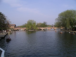
The River Avon in central England flows generally southwestwards and is a major left-bank tributary of the River Severn, of which it is the easternmost. It is also known as the Warwickshire Avon or Shakespeare's Avon, to distinguish it from several other rivers of the same name in the United Kingdom.

Chesapeake and Ohio Canal Canal in Washington, D.C. and Maryland, United States

The Chesapeake and Ohio Canal, abbreviated as the C&O Canal and occasionally called the "Grand Old Ditch," operated from 1831 until 1924 along the Potomac River from Washington, D.C., to Cumberland, Maryland. The canal's principal cargo was coal from the Allegheny Mountains.

Monongahela River River in Pennsylvania and West Virginia, United States

The Monongahela River —often referred to locally as the Mon —is a 130-mile-long (210 km) river on the Allegheny Plateau in north-central West Virginia and southwestern Pennsylvania. The river flows from the confluence of its west and east forks in north-central West Virginia northeasterly into southwestern Pennsylvania, then northerly to Pittsburgh and its confluence with the Allegheny River to form the Ohio River. The river's entire length is navigable via a series of locks and dams.

Rappahannock River

The Rappahannock River is a river in eastern Virginia, in the United States, approximately 195 miles (314 km) in length. It traverses the entire northern part of the state, from the Blue Ridge Mountains in the west where it rises, across the Piedmont to the Fall Line, and onward through the coastal plain to flow into the Chesapeake Bay, south of the Potomac River.

Fox–Wisconsin Waterway

The Fox–Wisconsin Waterway is a waterway formed by the Fox and Wisconsin Rivers. First used by European settlers in 1673 during the expedition of Marquette & Joliet, it was one of the principal routes used by travelers between the Great Lakes and the Mississippi River until the completion of the Illinois and Michigan Canal in 1848 and the arrival of railroads. The western terminus of the Fox–Wisconsin Waterway was at the Mississippi at Prairie du Chien, Wisconsin. It continued up the Wisconsin River about 116 miles (187 km) until reaching Portage, Wisconsin. There travelers would portage to the Upper Fox River, or eventually, use the Portage Canal. It continued about 160 miles (257 km) down the Fox River, following it through Lake Winnebago and continuing on the Lower Fox over 170 feet of falls to the eastern terminus of Green Bay.

Patowmack Canal United States historic place

The Patowmack Canal is a series of five inoperative canals located in Maryland and Virginia, United States, that was designed to bypass rapids in the Potomac River upstream of the present Washington, D.C. area. The most well known of them is the Great Falls skirting canal, whose remains are managed by the National Park Service as it is within Great Falls Park Virginia, an integral part of the George Washington Memorial Parkway.

James River and Kanawha Canal United States historic place

The James River and Kanawha Canal was a partially built canal in Virginia intended to facilitate shipments of passengers and freight by water between the western counties of Virginia and the coast. Ultimately its towpath became the roadbed for a rail line following the same course.

Rapidan River

The Rapidan River, flowing 88 miles (142 km) through north-central Virginia in the United States, is the largest tributary of the Rappahannock River. The two rivers converge just west of the city of Fredericksburg. The Rapidan River begins west of Doubletop Mountain in Shenandoah National Park where the Mill Prong meets the Laurel Prong at Rapidan Camp, approximately 3 miles (4.8 km) south of Big Meadows. The river defines the border of Orange County with Culpeper and Madison Counties.

McAlpine Locks and Dam Dam in Louisville, Kentucky

The McAlpine Locks and Dam are a set of locks and a hydroelectric dam at the Falls of the Ohio River at Louisville, Kentucky. They are located at mile point 606.8, and control a 72.9 miles (117.3 km) long navigation pool. The locks and their associated canal were the first major engineering project on the Ohio River, completed in 1830 as the Louisville and Portland Canal, designed to allow shipping traffic to navigate through the Falls of the Ohio.

Waterloo, Fauquier County, Virginia

Waterloo is a village in Fauquier County, Virginia, in the United States, straddling the Rappahannock River at its confluence with Carter's Run.

Rivanna River

The Rivanna River is a 42.1-mile-long (67.8 km) tributary of the James River in central Virginia in the United States. The Rivanna's tributaries originate in the Blue Ridge Mountains; via the James River, it is part of the watershed of Chesapeake Bay.

Goose Creek (Potomac River tributary)

Goose Creek is a 53.9-mile-long (86.7 km) tributary of the Potomac River in Fauquier and Loudoun counties in northern Virginia. It comprises the principal drainage system for the Loudoun Valley.

Locks on the Chesapeake and Ohio Canal

The Locks on the Chesapeake and Ohio Canal, located in Maryland, West Virginia, and Washington, D.C. of the United States, were of three types: lift locks; river locks; and guard, or inlet, locks.

Douglas Navigation

The Douglas Navigation was a canalised section of the River Douglas or Asland, in Lancashire, England, running from its confluence with the River Ribble to Wigan. It was authorised in 1720, and some work was carried out, but the undertakers lost most of the share money speculating on the South Sea Bubble. Alexander Leigh attempted to revive it eleven years later, and opened it progressively between 1738 and 1742. Leigh began work on a parallel canal called Leigh's Cut to improve the passage from Newburgh to Gathurst, but progress was slow and it was unfinished in 1771.

Lehigh Canal United States historic place

The Lehigh Canal or the Lehigh Navigation Canal is a navigable canal, beginning at the mouth of Nesquehoning Creek on the Lehigh River in Eastern Pennsylvania. It was built in two sections over a span of twenty years, beginning in 1818. The lower section spanned the distance between Easton, Pennsylvania and the town of Mauch Chunk, present-day Jim Thorpe, Pennsylvania. In Easton the canal met the Delaware and Morris Canals, with which goods could be brought further up the east coast. At its height, the Lehigh Canal was 72 miles (116 km) long.

Mersey and Irwell Navigation

The Mersey and Irwell Navigation was a river navigation in North West England, which provided a navigable route from the Mersey estuary to Salford and Manchester, by improving the course of the River Irwell and the River Mersey. Eight locks were constructed between 1724 and 1734, and the rivers were improved by the construction of new cuts several times subsequently. Use of the navigation declined from the 1870s, and it was ultimately superseded by the Manchester Ship Canal, the construction of which destroyed most of the Irwell section of the navigation and the long cut between Latchford and Runcorn.

Kaukauna Locks Historic District United States historic place

The Kaukauna Locks Historic District is a lock and dam system in Kaukauna, Wisconsin, United States that carried boat traffic around a rapids of the Fox River starting in the 1850s as part of the Fox–Wisconsin Waterway. It was added to the National Register of Historic Places in 1993 for its significance in engineering and transport.

Georges River Canal United States historic place

The Georges River Canal, also known as the General Knox Canal was a short-lived canal that operated on and near the course of the Saint George River in Knox and Waldo Counties in south-central Maine. First owned and operated by American Revolutionary War General Henry Knox between 1794 and 1806, it was briefly revived in 1847–50, but was not financially successful. It provided for transport of goods from near the river's headwaters in Searsmont to the head of navigation at Warren. A few elements of the canal survive today, and its route was listed on the National Register of Historic Places in 1970.

Upper Appomattox Canal Navigation System

The Upper Appomattox Canal Navigation system allowed farmers who took their wheat and corn to mills on the Appomattox River, as far way as Farmville, Virginia, to ship the flour all the way to Petersburg from 1745 to 1891. The system included a navigation, modifications on the Appomattox River, a Canal around the falls Petersburg, and a turning basin in Petersburg to turn their narrow long boats around, unload the farm products from upstream and load up with manufactured goods from Petersburg. In Petersburg, workers could put goods on ships bound for the Chesapeake Bay and load goods from far away for Farmville and plantations upstream. Canal boats would return up river with manufactured goods. People who could afford it, rode in boats on the canal as the fastest and most comfortable ride. The river was used for transportation and shipping goods for over 100 years.

Alexander John Marshall was a Virginia lawyer, businessman and politician who served many years as Clerk of Fauquier County, helped secure construction of the Rappahannock Canal, and was a Virginia state senator during the American Civil War (1862-1865).

References

  1. "Virginia Landmarks Register" (PDF). Virginia Department of Historic Resources. Retrieved September 9, 2018.
  2. This is because when the Rapahannock Company, a private enterprise of investors whose goal was to make the Rappahannock navaigable, failed the assets were distributed among the investors, of which the City of Fredericksburg was the largest.
  3. 1 2 3 4 5 US Department of the Interior, National Park Service, National Register of Historic Places Inventory and Nomination
  4. 1 2 3 Trout, p. 19.
  5. 1 2 3 Fauquier Historical Society, p. 3.
  6. Fauquier Historical Society, p. 1.
  7. Trout, p. 2.
  8. The Falmouth Canal and Its Mills: An Industrial History, John Janney Johnson, The Journal of Fredericksburg History, 1997, Vol. 2, pp.31-32.
  9. History of Remington, Virginia, viewed July 17, 2010.
  10. Trout, p. 3.
  11. 1 2 3 Trout, p. 22.
  12. Trout, p. 26. Although the author intended for this passage to reflect the condition of the entire navigation, it applies equally to the Rapidan Canal.
  13. The Virginia Landmarks Register, Calder Loth, Editor, The University Press of Virginia, p. 498, 1999.

Literature