Rastoke

Last updated
Rastoke
Settlement
Rastoke 1510.JPG
View of Rastoke
Croatia location map.svg
Red pog.svg
Rastoke
Coordinates: 45°07′16.55″N15°35′15.52″E / 45.1212639°N 15.5876444°E / 45.1212639; 15.5876444
Country Flag of Croatia.svg  Croatia
County Karlovac County
Municipality Slunj
Government
  MayorIvan Bogović (HDZ)
Area
[1]
  Total0.1 km2 (0.04 sq mi)
Population
 (2021) [2]
  Total46
  Density460/km2 (1,200/sq mi)
Time zone UTC+1 (CET)
  Summer (DST) UTC+2 (CEST)
Area code 047
Website slunj.hr

Rastoke (Croatian pronunciation: [rastoke] ) is a village, located in the Town of Slunj, known for the Slunjčica River, which flows into the Korana River at Rastoke.

Contents

At Rastoke, similar natural phenomena are occurring as at the Plitvice Lakes. Rastoke is sometimes known as "the Small Lakes of Plitvice", and is connected to the Plitvice Lakes by the Korana River. Rastoke is a place of autochthonous ecologic and ethnographic significance due to its symbiosis of natural and civilizational features.

The town of Slunj emerged around Rastoke and the branching of the Slunjčica and Korana rivers. The watermills erected at this place largely contributed to the economic development of Slunj as the center of the region of Kordun.

Origin of the place name

View to the historical part of Rastoke Rastoke in 2014 (1).JPG
View to the historical part of Rastoke

Rastoke as a place name has different meanings. The term generally refers to the branching of rivers. At Rastoke, the Slunjčica River (also called Slušnica by local people) splits into several river branches flowing across cascades and small waterfalls into the Korana river. Rastoke also refers to a certain kind of limestone called rastopina or rastok in Croatian. This stone, called travertine or tufa (Croatian sedra), is a product of permanent natural activities created by natural dissolution and sedimentation of calcium carbonate. The flowing water dissolves limestone into calcium carbonate. These particles in turn sediment along the cascades where the water is being stirred up. The quantity of carbon dioxide in the water plays a major role in this process of sedimentation. This effect slowly but permanently creates new rock along the river's cascades.

First mention

The first written document mentioning the town of Slunj was penned by Baron Johann Weikhard von Valvasor who describes the fortified town of Slunj, a bridge and a mill in 1689. The first depiction of the mills of Slunj dates back to 1789 when a copper engraving of the mills has been added to a travel report by Belsazar Hacquet, a writer of travel literature and author of the Oryctographia Carniolica (1789).

Rastoke as individual place name was first mentioned in 1860 in a travel report by Adolfo Veber Tkalčević, a priest, philologist and writer. Stjepan Širola described Rastoke as follows: "The surroundings of Slunj are downright romantic […]. They are crowned by the magnificent waterfalls of the Slunjčica River by which even not outspoken nature lovers will be captivated."

History of Slunj

The waterfalls of the Slunjčica, together with the Plitvice Lakes, have not been well known for a long time due to their rather isolated position. In medieval times, the region around Slunj was known as no man's land (Latin terra nullius), an uncertain border region between Europe and the Ottoman Empire. Slunj later became a stronghold of the Military Frontier. The fortification of Slovin built by the noble Frankopan family was an esteemed secure refuge, around which the town of Slunj evolved. The fortress was destroyed in 1578 and later rebuilt. A period of increasing resettlement and economic prosperity followed the Treaty of Sistova in 1791.

Slunj was under French reign from 1809 until 1813. During this time, Croatian became the official language of the province. The house of the former governor general of the French Illyrian Provinces marshal Auguste Marmont in Slunj still exists.

With the invention of electric mills and massive emigration after the First and the Second World War, the economic significance of the mills of Rastoke dramatically declined. In 1969, Rastoke was put under national monument protection.

The Slunjčica River and its natural phenomena

View of the settlement Rastoke 1126.JPG
View of the settlement
Waterfalls and cascades Rastoke 1167.JPG
Waterfalls and cascades

In the region of Lika, within the massif of the Mala Kapela mountain range and just beneath the Veliki Javornik top, lies the source of the Jesenica River. After only six kilometers this river disappears under the surface of the earth at Lička Jasenica and continues on a subterranean track for about 20 kilometers, as many other rivers in this karst region of Croatia. The river reemerges 6.5 kilometers south of Slunj as the Slunjčica River.

At the entry of the Slunjčica into the Korana River, there exists a natural travertine barrier consisting of a large accumulated lime deposit. Rastoke and the travertine barrier itself used to be separated into the "Upper" and the "Lower Rastoke" (Croatian "Gornje i donje Rastoke"). The lower part of Rastoke consists of 23 waterfalls, which fall about 10 to 20 meters deep into the Korana. The barrier as a whole consists of various small waterfalls, rapids and basins. The most famous waterfalls are Buk (English waterfall), Hrvoje and Vilina kosa (English fairy hair).

Due to its relatively short flow on the surface the water temperature of the Slunjčica is always lower than the water temperature of the nearby Korana River. The temperature varies from 6.5 to 7 °C during winter and the maximum of 16 °C during summer. In summer, the maximum temperature of the Korana River is about 28 °C.

The mills of Rastoke

Houses at the large waterfall Rastoke (2), Slunj, Croatia (new).JPG
Houses at the large waterfall
Outline of a watermill Slunj, Rastoke, Watermill outline.png
Outline of a watermill
Old corn mill Rastoke 1141.JPG
Old corn mill

Rastoke is known for its water powered mechanical mills. The architectural style of the region combines those of the Dinaric and the Posavina region. The ground parts of the houses are made out of travertine, while the higher parts consist of wood. The roofs are made by shingle or tiles. Due to high concentrations of calcium that regularly sediment at the openings between the cellar stones the ground parts have been covered by a layer of sinter. Thus, water cannot not run into the houses even at high water levels.

At its peak, Rastoke counted up to 22 mills. The first mill dates back to the 17th century. Many waterfalls carry the names of the mill owners.

The mills of Rastoke were driven by horizontally aligned paddle wheels. By utilizing a simple mechanism, water could be directed on to these paddle wheels whenever necessary. They in turn powered the rotating millstone. In order to accumulate enough power, a downward water fall of about three to five meters with an inclination of the wooden slope of at least 35 degrees was necessary.

Every mill had two or three, some even more millstones. Most millstones were used for grinding so called "black corn". This term then comprised the following sorts: maize, rye, barley, millet and oat. The best stones have been used for grinding so called "white corn" or wheat. The milling fees were about eight to ten percent of the delivered amount of corn.

Often there were attempts to conceal the quantities of corn. The millers had the difficult task of detecting this behavior. The milling profession lasted for a lifetime and was passed on in families for centuries. The abandonment of this profession only happened in cases of severe disputes and used to be regarded as a great shame.

Except for grinding, water power has also been used for the pounding or finalizing of woolen cloths. These cloths have once been regarded as most important clothing materials. In former times, at Rastoke a traditional form of washing machine has been used for washing clothes. The people of Rastoke used the same technological principle of today's washing machines: The clothes were washed in a rotating barrel with holes that was geared by the water flow.

Traditions and cuisine

Old houses Rastoke 1171.JPG
Old houses

Apart from milling, the people of Rastoke have also been known for their weaving of flax and hemp. The plants were grown by local people, soaked into the water of the Korana and then used for weaving. This was one of the main occupations of women, particularly during the cold winter months. The traditional costume of Slunj and Rastoke consists of these materials.

Rastoke follows the traditional customs of the Kordun region. For centuries, the relationship between the millers and the rest of the population, the grinding technique, the treatment of herbal textiles and wool, the customs, the language, the traditional dress, and much more had its impact on the living conditions of the citizens of Slunj and its surroundings.

The bread from Rastoke (Croatian rastočki domaći kruh) was well known in Croatia. It was made out of freshly ground grain, a combination of wheat, maize, barley, rye, and millet. This mixture was kneaded using the water of the Slunjčica and homemade yeast.

Changing events

A restaurant in Rastoke Rastoke 1136.JPG
A restaurant in Rastoke
Modern part of Rastoke Rastoke in 2014 (4).JPG
Modern part of Rastoke

During the night from 6 to 7 March 1914 a huge slide of the travertine barrier occurred due to the undercutting by the Korana River. This changed the flows of the waterfalls Hrvoje and Vilina kosa.

In 1962, Rastoke has been put under protection by the Croatian Institute for Conservation. In 1969, it was put under national monument protection due to its constructional, historic and ethnographic heritage (Registar nepokretnih spomenika kulture pri Regionalnom zavodu za zaštitu spomenika kulture u Zagrebu).

During the War in Croatia from 1991 to 1995, many century-old houses were partly destroyed. Particularly the attempted blast of the giant road bridge across the Korana by Serbian paramilitary troops before fleeing town in August 1995 caused substantial damage to the roofs of the traditional houses, and very limited harm to the road bridge. Local Serb militias, who regarded Slunj as their home region, severely damaged the waterfall Buk by throwing explosives on it during the occupation. After the end of war, the houses in this historic part of Slunj have been reconstructed so that hardly any damage can be seen today.

Tourism

The development of Rastoke as tourist attraction serves as a pilot project for the economic development of the town of Slunj and the surrounding region of Kordun due to being a place of autochthonous ecologic and ethnographic significance.

The region offers many activities for recreation, such as swimming, canoeing, rafting, fishing, hunting, mountain biking, hiking, riding, and spelunking. In August, the Festival of the town of Slunj takes place (Croatian Dani grada Slunja).

Sources

Related Research Articles

<span class="mw-page-title-main">Millstone</span> Stones used in gristmills, for grinding wheat or other grains

Millstones or mill stones are stones used in gristmills, used for triturating, crushing or, more specifically, grinding wheat or other grains. They are sometimes referred to as grindstones or grinding stones.

<span class="mw-page-title-main">Travertine</span> Form of limestone deposited by mineral springs

Travertine is a form of terrestrial limestone deposited around mineral springs, especially hot springs. It often has a fibrous or concentric appearance and exists in white, tan, cream-colored, and rusty varieties. It is formed by a process of rapid precipitation of calcium carbonate, often at the mouth of a hot spring or in a limestone cave. In the latter, it can form stalactites, stalagmites, and other speleothems. It is frequently used in Italy and elsewhere as a building material. Similar deposits formed from ambient-temperature water are known as tuff.

<span class="mw-page-title-main">Plitvice Lakes National Park</span> National park in Croatia

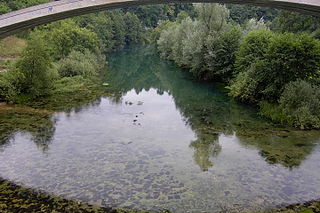
Plitvice Lakes National Park is one of the oldest and largest national parks in Croatia. In 1979, Plitvice Lakes National Park was inscribed on the UNESCO World Heritage list, due to its outstanding and picturesque series of tufa lakes, caves, connected by waterfalls.

<span class="mw-page-title-main">Tufa</span> Porous limestone rock formed when carbonate minerals precipitate out of ambient temperature water

Tufa is a variety of limestone formed when carbonate minerals precipitate out of water in unheated rivers or lakes. Geothermally heated hot springs sometimes produce similar carbonate deposits, which are known as travertine. Tufa is sometimes referred to as (meteogene) travertine. It should not be confused with hot spring (thermogene) travertine. Tufa, which is calcareous, should also not be confused with tuff, a porous volcanic rock with a similar etymology that is sometimes also called "tufa".

<span class="mw-page-title-main">Quern-stone</span> Stone tools for hand–grinding

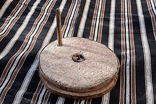
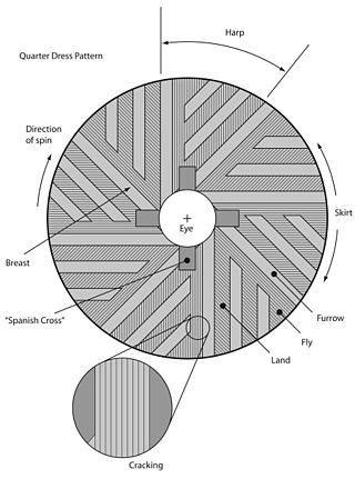
Quern-stones are stone tools for hand-grinding a wide variety of materials, especially for various types of grains. They are used in pairs. The lower stationary stone of early examples is called a saddle quern, while the upper mobile stone is called a muller, rubber, or handstone. The upper stone was moved in a back-and-forth motion across the saddle quern. Later querns are known as rotary querns. The central hole of a rotary quern is called the eye, and a dish in the upper surface is known as the hopper. A handle slot contained a handle which enabled the rotary quern to be rotated. They were first used in the Neolithic era to grind cereals into flour.

<span class="mw-page-title-main">Cetingrad</span> Municipality in Karlovac County, Croatia

Cetingrad is a municipality in Karlovac County, Croatia near Croatia's border with Bosnia. The population of the village itself is 319, while the total municipality population is 2,027 (2011). The municipality is part of Kordun. Cetingrad is underdeveloped municipality which is statistically classified as the First Category Area of Special State Concern by the Government of Croatia.

<span class="mw-page-title-main">Una (Sava)</span> River between Bosnia and Herzegovina and Croatia

The Una is a border river between Bosnia and Herzegovina and Croatia and a right tributary of the Sava river. It is part of the Black Sea drainage basin, and its watershed has a size of 10,200 km2 (3,900 sq mi), of which 8,080 km2 (3,120 sq mi) belongs to Bosnia and Herzegovina, and 2,120 km2 (820 sq mi) to Croatia. The total length of the river is 212 km (132 mi). The source of the river is located in the town of Donja Suvaja in Croatia, and its mouth is located near the town of Jasenovac, on the border with Bosnia. The largest right tributaries are the Krka, Unac, Krušnica and Sana rivers, and the largest left tributary is the Klokot river. Its longest headwater is the Unac river. The largest and most important city located on the river is Bihać. Other, important cities and towns are Bosanska Krupa, Bosanski Novi and Bosanska Kostajnica. The river is characterized by a multitude of waterfalls, rapids, karst springs and relatively untouched nature. A large part of the upper river is part of the Una National Park.

<span class="mw-page-title-main">Korana</span> River in Croatia, Bosnia and Herzegovina

The Korana is a river in central Croatia and west Bosnia and Herzegovina. The river has a total length of 138.6 km (86.1 mi) and watershed area of 2,301.5 km2 (888.6 sq mi).

<span class="mw-page-title-main">Slunj</span> Town in Karlovac County, Croatia

Slunj is a town in the mountainous part of Central Croatia, located along the important North-South route to the Adriatic Sea between Karlovac and Plitvice Lakes National Park, on the meeting of the rivers Korana and Slunjčica. Slunj has a population of 1,674, with a total of 5,076 people in the municipality (2011) and is the cultural and social center of the region of Kordun in the vicinity to Bosnia and Herzegovina. Administratively, the town is part of Karlovac County. Slunj is an underdeveloped municipality which is statistically classified as part of the First Category Area of Special State Concern by the Government of Croatia.

<span class="mw-page-title-main">Rakovica, Croatia</span> Municipality in Continental Croatia, Croatia

Rakovica is a village and a municipality in south-central Croatia, in the region of Kordun south of Karlovac and Slunj, and north of the Plitvice Lakes. Rakovica is an underdeveloped municipality which is statistically classified as the First Category Area of Special State Concern by the Government of Croatia.

<span class="mw-page-title-main">Kordun</span> Region of Croatia

The Kordun region is a part of central Croatia from the bottom of the Petrova Gora mountain range, which extends along the rivers Korana and Slunjčica, and forms part of the border region to Bosnia and Herzegovina. Within Croatia, Kordun is bordered by the Lika region to the south and by Banovina or Banija to the east.

<span class="mw-page-title-main">Slunjčica</span> River in Croatia

The Slunjčica is a river, which flows through the Kordun region in central Croatia. It partly flows underground through porous karst and surfaces in the vicinity of the city of Slunj. At Rastoke the Slunjčica leads into the river Korana, which reaches this point after passing the Plitvice Lakes National Park. The city of Slunj bears its name from this river. Due to its underground course the Slunjčica river has a quite cold temperature even during summer and the nearby situated towns use it as drinking water.

<span class="mw-page-title-main">Pliva (river)</span> River in Bosnia and Herzegovina

The Pliva is a relatively small river in central parts of Bosnia and Herzegovina, however one of the most significant in terms of natural, cultural and historical heritage and value as a natural rarity. For hundreds of years this region was the ultimate stronghold of the Bosnian Kingdom, with the town of Jajce as permanent seat of the last kings of the Bosnian Kingdom.

<span class="mw-page-title-main">Mrežnica</span> River in Croatia

The Mrežnica is a river in Karlovac County, Croatia. It is 63 kilometres (39 mi) long and its basin covers an area of 64 square kilometres (25 sq mi).

<span class="mw-page-title-main">Central Croatia</span> Historical region of Croatia

<span class="mw-page-title-main">Bentley Brook</span> River in England

Bentley Brook is a stream in Derbyshire, England. It rises on Matlock Moor, flowing south through Cuckoostone Dale, under the A632, into Lumsdale, gathering the valley's waters—notably from Knabhall Brook, out of Tansley, itself dammed and supporting large mills. In Lumsdale it enters a now disused mill pond or reservoir, then flows over a waterfall in the course of passing several historical mill ruins. Finally, it runs through control gates into the outside bend of a tight oxbow of the River Derwent, just beyond Hall Leys Park in Matlock. Although only about five miles in length, Bentley Brook is classed as a 'main river' by the Environment Agency.

<span class="mw-page-title-main">Trebižat (river)</span> River in Čapljina, Bosnia and Herzegovina

The Trebižat is a river in the southern part of Bosnia and Herzegovina, and major right tributary of the Neretva River.

<span class="mw-page-title-main">Gristmill</span> Mill; grinds grain into flour

A gristmill grinds cereal grain into flour and middlings. The term can refer to either the grinding mechanism or the building that holds it. Grist is grain that has been separated from its chaff in preparation for grinding.

<span class="mw-page-title-main">Siege of Bihać (1592)</span>

The siege of Bihać was the besieging and capture of the city of Bihać, Kingdom of Croatia within Habsburg monarchy, by the Ottoman Empire in June 1592. With the arrival of Hasan-paša Predojević as the Beylerbey of the Bosnia Eyalet in 1591, a period of peace established between Emperor Rudolf II and Sultan Murad III ended and the provincial Ottoman armies launched an offensive on Croatia. Bihać, a nearly isolated city on the Una River that repelled an Ottoman attack in 1585, was one of the first targets. Thomas Erdődy, the Ban of Croatia, used available resources and soldiers to protect the border towns, but the Ottomans managed to take several smaller forts in 1591. As the offensive gained pace, the Croatian Parliament passed a law on a general uprising in the country on 5 January 1592.

Blagaj is a medieval ruined castle located on the right bank of the Korana river in modern Karlovac county, Croatia. Around it formed an eponymous village, Blagaj. It has a rectangular floorplan, and was once one of the larger castles in the region, with a central tower, similar to Belaj, Karlovac county. The old parish church of Sv. Duh is proposed to have been situated not far from the ruins, where there are today two churches next to each other.

References

  1. Register of spatial units of the State Geodetic Administration of the Republic of Croatia. Wikidata   Q119585703.
  2. "Population by Age and Sex, by Settlements, 2021 Census". Census of Population, Households and Dwellings in 2021. Zagreb: Croatian Bureau of Statistics. 2022.