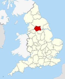
West Yorkshire is a metropolitan and ceremonial county in England. It is an inland and, in relative terms, upland county having eastward-draining valleys while taking in the moors of the Pennines. West Yorkshire came into existence as a metropolitan county in 1974 after the passage of the Local Government Act 1972 and has a population of 2.3 million. Its largest settlements are Leeds, Bradford, Huddersfield, Wakefield, Halifax, Keighley and Dewsbury.

Batley is a market town in the Metropolitan Borough of Kirklees, in West Yorkshire, England. Batley lies south-west of Leeds, north-west of Wakefield and Dewsbury, south-east of Bradford and north-east of Huddersfield. Batley is part of the Heavy Woollen District. In 2011 the population of Batley including Hanging Heaton, Staincliffe, Carlinghow, Birstall, Birstall Smithies, Copley Hill and Howden Clough was 48,730.

Dewsbury is a minster and market town in the Metropolitan Borough of Kirklees in West Yorkshire, England. It lies on the River Calder and on an arm of the Calder and Hebble Navigation waterway. It is to the west of Wakefield, east of Huddersfield and south of Leeds.

Ossett is a market town in the City of Wakefield metropolitan borough in West Yorkshire, England. Historically part of the West Riding of Yorkshire, it is situated between Dewsbury, Horbury and Wakefield. At the 2011 Census, the population was 21,231. Ossett forms part of the Heavy Woollen District.

Huddersfield is a large market town in the Metropolitan Borough of Kirklees, West Yorkshire, England. Huddersfield was a prominent mill town in the industrial revolution. To the town's west are the Pennines, south is the River Holme's discharge into the similar-sized Colne. The town's historic county is the West Riding of Yorkshire.

Beeston is a suburb of Leeds, West Yorkshire, England located on a hill about 2 miles (3 km) south of the city centre.

The Huddersfield line is the main railway line between the English cities of Leeds and Manchester via Huddersfield. It is one of the busiest MetroTrain lines. The route travels south-south west from Leeds through Dewsbury. After a short westward stretch through Mirfield, it continues south west through Huddersfield, using the Colne Valley to its headwaters. The long Standedge Tunnel just after Marsden crosses under the watershed and the majority of the run down to Manchester is in the Tame valley. From Manchester, some services continue to Manchester Airport and others to Liverpool.
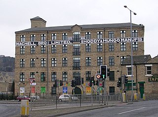
The Heavy Woollen District is a region of textile-focused industrial development in West Yorkshire, England. It acquired the name because of the heavyweight cloth manufactured there from the early 19th century.
Huddersfield railway station serves the town of Huddersfield in West Yorkshire, England.

Ravensthorpe railway station serves the Ravensthorpe suburb of Dewsbury in West Yorkshire, England. It is situated on the Huddersfield line between Leeds and Manchester, 8 miles (13 km) north east of Huddersfield.

Dewsbury railway station serves the town of Dewsbury in West Yorkshire, England. Situated 9.25 miles (15 km) south west of Leeds on the main line to Huddersfield and Manchester, the station was opened by the London and North Western Railway in 1848.

Gildersome is a village and civil parish in the City of Leeds metropolitan borough 5 miles (7 km) south-west of Leeds city centre in West Yorkshire, England. Glidersome forms part of the Heavy Woollen District.

Brockholes is a small village in West Yorkshire, England, in the administrative area of Kirklees Metropolitan Council and Holme Valley Parish Council. The village of Honley borders to the immediate north of the village and Holmfirth lies to the south. Brockholes is within the Postal district of Holmfirth.

Holbeck is an inner city area of Leeds, West Yorkshire, England. It begins on the southern edge of Leeds city centre and mainly lies in the LS11 postcode district. The M1 and M621 motorways used to end/begin in Holbeck. Now the M621 is the only motorway that passes through the area since the end of the M1 moved to Hook Moor near Aberford. Since large parts of Holbeck have been vacated in preparation for the regeneration of the area, the district has in large parts suffered from a population exodus. Holbeck had a population of 5,505 in 2011. The district currently falls within the Beeston and Holbeck ward of Leeds City Council.

The West Yorkshire Fire and Rescue Service (WYFRS) is the county-wide, statutory emergency fire and rescue service for the metropolitan county of West Yorkshire, England. It is administered by a joint authority of 22 people who are appointed annually from the five metropolitan boroughs of West Yorkshire, known as the Fire and Rescue Authority.
The Dewsbury riot of 1989 was a minor clash between activists of the British National Party (BNP) and local South Asian youths. The police used riot gear in controlling the events.

Halifax is a minster and market town in the Metropolitan Borough of Calderdale in West Yorkshire, England. It is the commercial, cultural and administrative centre of the borough, and the headquarters of Calderdale Council. In the 15th century, the town became an economic hub of the old West Riding of Yorkshire, primarily in woollen manufacture. Halifax is the largest town in the wider Calderdale borough. Halifax was a thriving mill town during the industrial revolution.
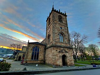
Dewsbury Minster, the Minster Church of All Saints is the parish church in Dewsbury, Kirklees, West Yorkshire, England. It dates from the 13th century and was rebuilt in 1895. It is situated on Vicarage Road and Church Street in the centre of the town. In 1949 it gained Grade II* listed status. Dewsbury Parish Church was rededicated as a minster church in 1994. It is one of three churches in West Yorkshire to be given the honorific title "minster". The others are Halifax Minster and Leeds Minster.

The Spen Valley Line was a railway that connected Mirfield with Low Moor through the Spen Valley in West Yorkshire, England. Opened up by the Lancashire and Yorkshire Railway in 1847, with full opening to Low Moor in 1848, the line served a busy industrial and textile area and allowed a connection for trains between Huddersfield and Bradford. The line was absorbed by the London & North Western Railway, the London Midland and Scottish Railway (LMS) and British Railways on Nationalisation. A separate link between Heckmondwike Central and Thornhill that opened later and was known as the Ravensthorpe Branch, allowed through running to Wakefield and beyond. The line was closed down to passengers in 1965 with freight continuing sporadically until 1981. A Spur onto the former Leeds New Line from the Ravensthorpe Branch kept the very southern end open until the late 1980s. The majority of the route is now the Spen Valley Greenway cycle path.

Sunny Bank Mills is a former textile mill, which specialised in worsted cloth, set in 10 acres of land located on Town Street, Farsley, Leeds, England. Since 2010, it has been developed as a business and artistic community, with an exhibitions gallery selling fine art by local artists; a textile and local history archive; shops, cafés, artist studios; as well as outdoor spaces. It is run by the Gaunt family who took ownership in 1943. The archive was awarded Archive Community Accreditation by West Yorkshire Archive Service in January 2021.

