
Warragul is a town in Victoria, Australia, 102 kilometres south-east of Melbourne. Warragul lies between the Strzelecki Ranges to the south and the Mount Baw Baw Plateau of the Great Dividing Range to the north. As at the 2016 census, the town had a population of 14,276 people. Warragul forms part of a larger urban area that includes nearby Drouin that had an estimated total population of 37,928 at June 2018.

The Shire of Baw Baw is a local government area in Victoria, Australia, in the eastern part of the state. It covers an area of 4,028 square kilometres (1,555 sq mi) and in June 2018 had a population of 52,015.
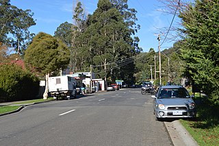
Noojee is a town in the Gippsland region of Victoria, Australia, north of Warragul and east of Melbourne, in the Baw Baw local government area. At the 2016 census, Noojee and the surrounding area had a population of 157. The town benefits from tourists passing through to the Mount Baw Baw Alpine Resort, 48 kilometres away, as it is the last stop with tourism services. There are also a number of walks in the area, including the Noojee Trestle Bridge, a 100m wooden rail bridge.

Drouin is a town in the West Gippsland region, 90 kilometres (56 mi) east of Melbourne, in the Australian state of Victoria. Its local government area is the Shire of Baw Baw, and is home to the council headquarters despite being the second-largest town in the shire, behind neighbouring Warragul. The town is supposedly named after a Frenchman who invented a chlorination process for the extraction of ore, or an Aboriginal word meaning "north wind". New housing developments have accelerated the town's residential growth in recent years. As at the 2016 census, Drouin had a population of 11,887 people.

Moe is a town in the Latrobe Valley in the Gippsland region of Victoria, Australia. It is approximately 130 kilometres east of the central business district of Melbourne, 45 kilometres due south of the peak of Mount Baw Baw in the Great Dividing Range and features views of the Baw Baw Ranges to the north and Strzelecki Ranges to the south.

Walhalla is a small town in Victoria, Australia, founded as a gold-mining community in late 1862, and at its peak, home to around 4,000 residents. As of 2016, the town has a population of 20 permanent residents, though it has a large proportion of houses owned as holiday properties. It attracts large numbers of tourists and is a major focus of the regional tourism industry. The town's name is taken from an early gold mine in the area, named for the German hall of fame, the Walhalla temple.

Athlone is a small town in Victoria, Australia. It is located on Drouin - Korumburra Road, in the Shire of Baw Baw.
Tanjil Bren is a town in Victoria, Australia, on Mount Baw Baw Tourist Road, 12 kilometres (7 mi) west of Mount Baw Baw in the Shire of Baw Baw. It was established during the Victorian Gold Rush. Four accommodation lodges, Mooshead, Reindeer, Jenny's and Timbertop Lodge, are located in Tanjil Bren. At the 2006 census, Tanjil Bren and the surrounding area had a population of 110.

Neerim South is a town in West Gippsland, Victoria, Australia, located in the Shire of Baw Baw, 109 kilometres (68 mi) east of Melbourne and 19 kilometres (12 mi) north of Warragul. At the 2016 census, Neerim South had a population of 1,305.

Parkers Corner is a town in Victoria, Australia, located at the junction of Rawson Road and Tyers - Thomson Valley Road, in the Shire of Baw Baw. With only 12 residents, it is the third-smallest town in Victoria.

Erica is a town in Victoria, Australia, on Rawson Road, in the Shire of Baw Baw.
Darnum is a small town in West Gippsland, Victoria, Australia, located 110 km east of Melbourne and a short distance to Warragul, in the Shire of Baw Baw. It is nestled between the Great Dividing Range and Strzelecki Ranges. The Moe River meanders through the edge of the township which the historic Darnum Butter Factory overlooks.

The Walhalla Goldfields Railway is a 2 ft 6 in narrow gauge tourist railway located in the Thomson River and Stringers Creek valleys in Gippsland, Victoria, Australia, near the former gold-mining town and tourist destination of Walhalla.

The Walhalla railway line was a 2 ft 6 in narrow gauge railway located in Gippsland, Victoria, Australia. The line ran from Moe to the former gold-mining town and popular tourist destination of Walhalla. Construction began in 1904. The line closed in sections from 1944 to 1954.
Willow Grove is a village and rural farming community located in the Baw Baw foothills. It is northwest of Moe in Victoria, Australia and North of Trafalgar. It has a primary school, football club, tennis courts, community hall, general store, CFA shed, and kindergarten. It is a popular tourist destination where people can enjoy trail bike riding, camping, four wheel driving & hunting. The next town to the west is Hill End and to the east Tanjil South. Willow Grove is situated within the Shire of Baw Baw and shares the postcode 3825. At the 2006 census, Willow Grove and the surrounding area had a population of 221.

Longwarry is a town in Victoria, Australia, 83 kilometres (52 mi) south-east of Melbourne's Central Business District, located within the Shires of Baw Baw and Cardinia local government areas. Longwarry recorded a population of 2,004 at the 2016 Census. Longwarry has one primary school, Longwarry Primary School.

The Shire of Narracan was a local government area about 120 kilometres (75 mi) east-southeast of Melbourne, the state capital of Victoria, Australia. The shire covered an area of 2,300 square kilometres (888.0 sq mi) and existed from 1878 until 1994.

Modella is a bounded rural locality in Victoria, Australia, 77 kilometres (48 mi) south-east of Melbourne's Central Business District, located within the Shires of Baw Baw and Cardinia local government areas. Modella recorded a population of 148 at the 2016 Census.
Labertouche is a town in Victoria, Australia, located on Jacksons Track, in the Shire of Baw Baw. At the 2016 Census, Labertouche had a population of 356.
Coopers Creek is a former township and mine in the Gippsland region of Victoria, Australia. In the 1860s, Coopers Creek was settled during the Victorian gold rush and, throughout its history, gold, copper and lime have been mined there. Today, Coopers Creek is effectively limited to two camping sites, the first near the site of the mining town and the second to the east at Bruntons Bridge. Ruins from the town's mining history, and the Copper Mine Hotel are all of the town's history which survives.
