Qinghai Lake, Koko Nor or Tso Ngonpo is the largest lake in China. Located in Qinghai province on an endorheic basin, Qinghai Lake is classified as a saline and alkaline lake. Qinghai Lake has a surface area of 4,317 square kilometres (1,667 sq mi); an average depth of 21 metres (69 ft), and a maximum depth of 25.5 m (84 ft) as measured in 2008. The current Chinese name "Qinghai," the older Mongolian name "Kokonor", and the Tibetan name translate to "Green Sea", "Blue Lake" and "Teal Sea", respectively. Qinghai Lake is located about 100 kilometres (62 mi) west of the provincial capital of Xining at 3,205 m (10,515 ft) above sea level in a hollow of the Tibetan plateau. Twenty-three rivers and streams empty into Qinghai Lake, most of them seasonal. Five permanent streams provide 80% of total influx.
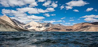
Pangong Tso, Tibetan for "high grassland lake", also referred to as Pangong Lake, is an endorheic lake in the Himalayas situated at a height of about 4,350 m (14,270 ft). It is 134 km (83 mi) long and extends from India to the Tibetan Autonomous Region, China. Approximately 60% of the length of the lake lies within the Tibetan Autonomous Region. The lake is 5 km (3.1 mi) wide at its broadest point. All together it covers 604 km2. During winter the lake freezes completely, despite being saline water. It is not a part of the Indus river basin area and geographically a separate landlocked river basin.
Gyantse, officially Gyangzê Town, is a town located in Gyantse County, Shigatse Prefecture, Tibet Autonomous Region, China. It was historically considered the third largest and most prominent town in the Tibet region, but there are now at least ten larger Tibetan cities.
Yamdrok Lake is a freshwater lake in Tibet, it is one of the three largest sacred lakes in Tibet. It is over 72 km (45 mi) long. The lake is surrounded by many snow-capped mountains and is fed by numerous small streams. The lake has an outlet stream at its far western end and means turquoise in English due to its color.
Shannan, also transliterated from Tibetan as Lhoka, is a prefecture-level city in the southeastern Tibet Autonomous Region, China. Shannan includes Gonggar County within its jurisdiction with Gongkar Chö Monastery, Gonggar Dzong, and Gonggar Airport all located near Gonggar town.

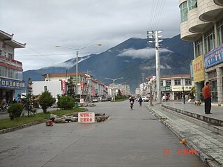
Chengguan synonymously referred to as Chamdo or Qamdo is a major town in the historical region of Kham in the eastern Tibet Autonomous Region of China. The seat of Karub District and Chamdo Prefecture, it is Tibet's third largest city after Lhasa and Shigatse with a population of 45,861 in 2010. It is located about 600 km (370 mi) east of Lhasa. By road, the distance is 1,120 km (700 mi) via the southern route or 1,030 km (640 mi) via the northern route. It is at an altitude of 3,230 m (10,600 ft) at the confluence of the rivers Za Qu and Ngom Qu which form the Lancang River (Mekong).

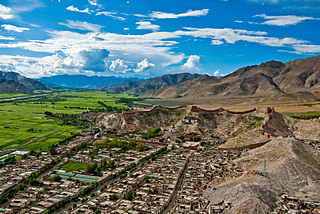
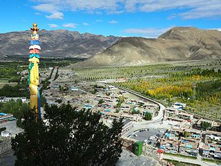
Zêtang, also Zedang or Tsethang, is the fourth largest city in Tibet and is located in the Yarlung Valley, 183 km (114 mi) southeast of Lhasa in Nêdong District of Shannan, Tibet Autonomous Region of China. As capital of Shannan City, it "...exercises direct control over the affairs of 13 counties: Gongkar, Tranang, Nedong, Changye, Tso-me, Lhodrok, Nakartse, Zangri, Chutsum, Lhuntse, Tsona, Gyatsa and Nang."
Nyalam is a small Tibetan town near the Nepal border. It is the county seat of Nyalam County in Shigatse Prefecture It is 35 km from Zhangmu town in the same county, which is the point of entry to Nepal. Nyalam is situated at 3,750 metres (12,300 ft) above sea level.

Xainza County, also Shantsa, Shentsa, is a county within Nagqu of the Tibet Autonomous Region of China. In 1999 the county had a population of 16,190.

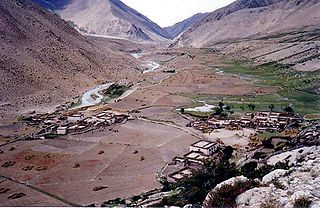
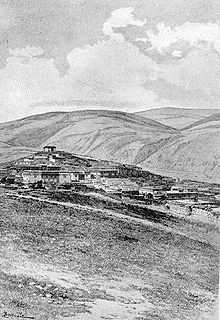
Bamda is a small township in Markam County in the south-east of the Tibet Autonomous Region of China, roughly 1,000 kilometres (600 mi) from Lhasa. It is basically an army garrison with a small Tibetan village around the corner.
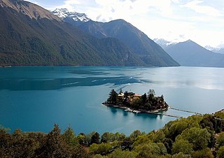
Tsozong Gongba Monastery is a small Tibetan Buddhism monastery in eastern Tibet, China. The monastery, founded in 1400, practices the Nyingma tradition. Tsozong Gongba is located on Tashi Island in the middle of Pagsum Lake in the Nyenchen Tanglha Mountains, part of Gongbo'gyamda County in Nyingchi Prefecture, Tibet Autonomous Region. Tsozong Gongba means "castle in the lake" in Tibetan. The monastery has four buildings situated around a small yard.

Gyaca County, is a county of Shannan located in the south-east of the Tibet Autonomous Region, China.
Coqên is a town and seat of Coqên County in Ngari Prefecture of the Tibet Autonomous Region of China. It lies at an altitude of 4,718 metres. It is on the main route between Lhasa and Kashgar, northwest of Lhaze. Lakes not too far away include Zhari Nanmu Lake, Dawa Lake and Taruo Lake.
Tangmai is a village in the Tibet Autonomous Region of China set in lush jungle with ferns and monkeys. The altitude is about 1,700 m (5,577 ft). There is a truckstop hotel but no real town.
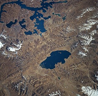
Lhamo Latso or Lha-mo La-tso is a small oval oracle lake where senior Tibetan monks of the Gelug sect go for visions to assist in the discovery of reincarnations of the Dalai Lamas. Other pilgrims also come to seek visions. It is considered to be the most sacred lake in Tibet.
Litang Town is the administrative centre of Litang County in the southwest of the Garzê Tibetan Autonomous Prefecture in Sichuan Province of China.
Bayi is a subdistrict in Tibet and seat of Bayi District. It lies on the Nyang River at an altitude of 2,994 metres. Bayi is an important timber and wool producing town, known historically before the 1960s as Lhabagar. By road it is 405 kilometres (252 mi) east of Lhasa on the way to Chengdu.

Ikertooq Fjord is a 55 km (34 mi) long fjord in the Qeqqata municipality in western Greenland. The fjord empties into Davis Strait 21 km (13 mi) south of Sisimiut.
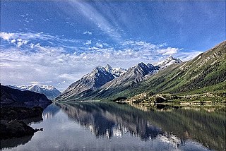
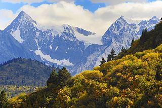
Rakwa Tso, also known as Rawu Tso or Ranwu Lake, is a lake in Baxoi County, Chamdo Prefecture, Tibet, China, to the north of Arza Gongla Glacier, and to the south of Ngagung Tso. The lake covers an area of 27 km2 (10 sq mi), and has an elevation of 3,850 metres. The lake was created by a landslide dam. Parlung River flows out of the lake.