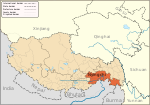
Tibet is a region in Asia, covering much of the Tibetan Plateau and spanning about 2,500,000 km2 (970,000 sq mi). It is the homeland of the Tibetan people. Also resident on the plateau are some other ethnic groups such as the Monpa, Tamang, Qiang, Sherpa and Lhoba peoples and, since the 20th century, considerable numbers of Han Chinese and Hui settlers. Since the 1951 annexation of Tibet by the People's Republic of China, the entire plateau has been under the administration of the People's Republic of China. Tibet is divided administratively into the Tibet Autonomous Region, and parts of the Qinghai and Sichuan provinces.

The Tibet Autonomous Region or Xizang Autonomous Region, often shortened to Tibet or Xizang, is a province-level autonomous region of the People's Republic of China in Southwest China. It was overlayed on the traditional Tibetan regions of Ü-Tsang and Kham.

Qinghai, also known as Kokonor, is a landlocked province in the northwest of the People's Republic of China. It is the fourth largest province of China by area and has the third smallest population. Its capital and largest city is Xining.

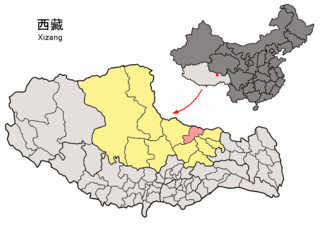
Shigatse, officially known as Xigazê, is a prefecture-level city of the Tibet Autonomous Region of the People's Republic of China. Its area of jurisdiction, with an area of 182,000 km2 (70,271 sq mi), corresponds to the historical Tsang region of Tibet.
Huangnan Tibetan Autonomous Prefecture is an autonomous prefecture of Eastern Qinghai, China, bordering Gansu to the east. The prefecture has area of 17,921 km2 (6,919 sq mi) and its seat is in Tongren County.
Rutog County, is a county in Ngari Prefecture, Tibet Autonomous Region of the People's Republic of China. The county seat is the new Rutog Town, located some 1,140 km (710 mi) or 700 miles west-northwest of the Tibetan capital, Lhasa. Rutog County shares a border with India.
Nyainrong County is a small county under the administration of the prefecture-level city of Nagqu, in the north of the Tibet Autonomous Region, bordering Qinghai province to the north. Yurla is a favourite of the people of the county.

Lhorong County is a county of the Qamdo Prefecture in the Tibet Autonomous Region. The county covers an area of 8,108 km2 (3,131 sq mi) and has a population of around 40,000 as of 2003. The word Lhorong means "valley in the south" or "river in the south" in Tibetan.

Dragsum Tsho (Tibetan: བྲག་གསུམ་མཚོ་, Wylie: brag gsum mtsho, THL: Draksum Tso, Pagsum Co, literally meaning “three rocks” in Tibetan, is a lake covering 28 square kilometres in Gongbo'gyamda County, Nyingchi of the Tibet Autonomous Region, China, approximately 300 km east of Lhasa. At 3,700 metres over sea level it is about 18 km long and has an average width of approximately 1.5 km. The deepest point of the green lake measures 120 metres. The lake is also known as Gongga Lake.

Gyaca County, is a county of Shannan located in the south-east of the Tibet Autonomous Region, China.

Gertse County, Gêrzê County or Gaize County is a county located in Ngari Prefecture in the northwest of the Tibet Autonomous Region, bordering Xinjiang to the north.
Bangxing is a township in Medog County, Tibet Autonomous Region of the People's Republic of China. It lies at an altitude of 2,161 metres (7,090 ft). Its population in 2007 was 1,351, the town is located in the traditional province of Pemako, most of the inhabitants are Tshangla speakers.
Bünsum, Gyaimain is a village in Qonggyai County, Tibet Autonomous Region of China. It lies at an altitude of 4,755 metres.
Drakna, Drakne, or Chagnê is a township in Gyirong County, Tibet Autonomous Region of China.
Chênggo is a township in Gonggar County, Tibet Autonomous Region of China. It lies at an altitude of 4,744 metres.
Dêlêg is a village in Xaitongmoin county of Shigatse Prefecture in the Tibet Autonomous Region of China, northeast of the county seat. The Tibetan name means "good luck". It lies at an elevation of 4,804 metres. In 2007 the village had a population of about 350.
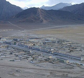
Gar Chongsar or Gar Xincun, Gar New Village, is a village in Gar County, Ngari Prefecture, Tibet Autonomous Region, China. It is the site of the Ngari Gunsa Airport.
Sogmai, or Suomai is a village in Günsa Township, Gar County, Tibet Autonomous Region, China. It is the site of the Ngari Gunsa Airport.
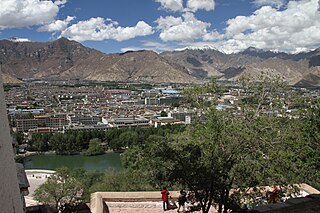
Lhasa is a prefecture-level city, one of the main administrative divisions of the Tibet Autonomous Region of China. It covers an area of 29,274 square kilometres (11,303 sq mi) of rugged and sparsely populated terrain. Its capital and largest city is Lhasa, with around 300,000 residents, which mostly corresponds with the administrative Chengguan District, while its suburbs extend into Doilungdêqên District and Dagzê District. The consolidated prefecture-level city contains additional five, mostly rural, counties.
Gyacoxung is a township of Samzhubzê District, in the Tibet Autonomous Region of China. At the time of the 2010 census, the township had a population of 11,946 and an area of 471 square kilometres (182 sq mi). Xigazê railway station is located here.