Two hundred were built, because the coal in the surrounding mountains was ideal for refining into coke. At their peak, they were producing almost 6 million tons a year. The development was the beginning of the modern settlement of Redstone. There are very few coke ovens of their type remaining in the West;[1] the ovens are themselves the only remnant of the sizable coking operation in the area, the largest at the time in Colorado.
Within ten years of their construction the ovens fell into disuse when the mines closed. Their support steel was removed during the scrap metal drives of World War II, and later they were used as living space by hippies who moved into Redstone.[2] The possibility that some might be demolished to build a gas station eventually led Pitkin County to acquire the land in the mid-2000s,[3] and since then some have been restored.[4]
Geography
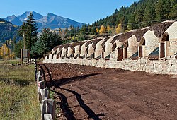
The remaining 90 coke ovens are arranged in a 600-foot–long (180m) arc over a 4-acre (1.6ha) area along the west side of Highway 133 south of Coal Creek just opposite where Redstone Boulevard crosses the Crystal River into downtown Redstone. There is a small parking area and interpretive plaque, the only contributing resource in the district other than the ovens.[5] In the middle is a gate leading to the current facility of Mid-Continent Coal & Coke, which now owns the property.[6]
Most of the structures are freestanding beehive ovens made of stone, their rounded tops covered with hardened brown earth. Some retain their original integrity; many have decayed visibly over the years. Four have been restored to their original appearance. A set in the middle, just north of the parking area and entrance, is within a stone retaining wall added in the mid-20th century (due to this, neither it nor the ovens it protects are considered to be contributing to the historic district[7]). Wooden guardrails and fences keep visitors from getting too close.
History
The history of the coke ovens is the history of Redstone. They went online during the town's peak period of population, and were shut down less than a decade later, never to be used again.[8] They were left to decay throughout much of the rest of the century, as Redstone itself nearly became a ghost town. A century after their construction, as the village turned around, they were restored as a historic attraction.[4]
1700s–1860: European settlement of the Crystal River Valley
The isolation of the Crystal Valley allowed the native Ute people to avoid contact with European colonists until they encountered the Spanish in the late 18th century. By the 1830s, traders and fur trappers were working in the region. The Astor family began supporting the latter during the next decade, and John C. Frémont led the first American expedition to the valley in 1843, returning two years later.[8]
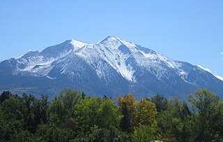
Prospectors looking for gold in 1860 were disappointed, but named the 12,965-foot (3,952m)Mount Sopris that dominates the valley after their leader. After the American Civil War, the federal government concluded treaties with the Utes and otherwise began to encourage settlement in the region, that its rich mineral resources might be exploited. The surveys of Ferdinand Vandeveer Hayden in 1873 gave names to many other mountains and streams in the region and suggested the Crystal Valley might well be rich in coal.[8]
1880–1900: Early mine development
Silver and lead strikes led to the establishment of now-abandoned settlements like Crystal and Schofield further up the valley, along the river's upper forks in what is now Gunnison County. In 1880 the Ute ceded the area to European settlement, in preparation for their relocation to reservations elsewhere in Colorado and Utah the following year. Prospectors swarmed into the area, looking for all types of mineral deposits.[8]
John C. Osgood
In 1882, one of them, John Cleveland Osgood, was sent by the Chicago, Burlington and Quincy Railroad (CBQRR), which bought some of its coal from his employer, the White Breast Coal Company. His visit was part of a general survey of the state's coal resources, and he found them desirable enough that he set up the Colorado Fuel Company the following year to supply the Burlington and Missouri River Railroad, a CBQRR subsidiary, with coal. He had also found the Crystal River Valley's deposits ideal for coking, and bought land there.[8]
Four years later, he and his associates at Colorado Fuel set up both a toll road company and a railroad to make the valley accessible. Some surveying was done over the next two years, but no construction began. In 1888, the rival Colorado Coal and Iron Company built the Aspen and Western Railway to Willow Park, west of Carbondale, to exploit coal deposits there. The coal was found to be of poor quality, so plans for a coking facility there were canceled and the rail line abandoned the next year. Similarly, another rail line along the Crystal was surveyed and graded, but no actual tracks were ever laid.[8]
Afterwards, another Colorado Fuel subsidiary, Elk Mountain Fuel, was formed to buy land near the present site of Redstone in the area known as Coal Basin. It eventually merged with the parent, and in 1892, Colorado Fuel and its rival Colorado Coal and Iron merged to become Colorado Fuel and Iron (CF&I), controlling two-thirds of the state's coal mining and becoming the largest coal company in the West, headed by Osgood. The combined company was finally in a position to realize the transportation plans made over the past decade.[8]
Osgood planned to build a mining town, Coalbasin, high up the Coal Creek valley, where coal desirable for coking due to its purity and low ash content was abundant. From there, a narrow gauge railway would descend 12 miles (19km) and 2,200 feet (670m) to Redstone on the river, where coal could be both coked and transferred to standard gauge cars bound for Carbondale and other destinations via the Denver and Rio Grande Western and Colorado Midland. The Panic of 1893 delayed those plans, due to the failure of many of the state's banks and the ensuing difficulty in finding financing, to the end of the decade.[8]
1900–1925: Peak mining years and collapse
Workers building the ovens, 1902
By the end of 1899, 249 ovens, the largest coking facility in the state, had been built by contractors from Denver.[4] They were operated by a work force that accounted for 10% of all Colorado's workers at the time. Coking workers were predominantly immigrants from Eastern Europe, whom the company had recruited from the East. Another mine was opened in Placita, to the south, and by 1902, the ovens had produced almost 5.7 million tons (5.2 million tonnes) of coke. Osgood developed the village of Redstone personally, at a cost of $5 million ($169million in modern dollars[9])[10] as a planned community so that workers would have quality housing, frequently an issue in strikes of the era. Further up the valley, he built an estate he called Cleveholm but would later be known as Osgood Castle.[8]
The large work force was often restive, and their strikes hobbled CF&I at a time when it was making major investments in its Pueblo steel plant. Osgood turned to Eastern investors for help; by 1903, interests indirectly controlled by George Gould and John D. Rockefeller had gained control of CF&I. Osgood started the Victor American Fuel Company, which soon became CF&I's biggest competitor.[8]
CF&I's Pueblo plant became the state's largest coke buyer by the end of the decade. It was unprofitable to ship the fuel there from the Crystal River Valley, and by 1909 all mining and coking operations ended. Redstone was abandoned, with only a few residents remaining.[8] Osgood, who had largely retreated to New York City, returned to his estate in 1924 to attempt to redevelop the area as a resort. He died the following year, and his wife Lucille completed transforming the estate into a hotel. However, it failed due to the onset of the Great Depression shortly afterwards.[10]
1926–present: Neglect and restoration
At the outset of World War II, the community's population was down to 14.[10] During the war, the ovens' steel supports were removed during the scrap metal drives, leaving them vulnerable to structural decay. In 1953, some of the ovens near the center of the group were stabilized with a stone retaining wall,[7] when another company, Mid-Continent, began working the coal seams in the creek valley again.[3]
The other ovens suffered some decay, but were still structurally sound enough to avoid collapse. In the late 1960s and early 1970s, many of the young hippies and other countercultural youth of the time were drawn to the Colorado mountains, among other places, where they believed they could live lives closer to nature. Many came to Pitkin County to settle in its seat, Aspen, but some found the smaller and quieter Redstone more desirable instead. Some used the ovens as short- or long-term living quarters.[2]
Eventually the hippies left or settled in more traditional housing. Residents continued to pillage brick and stone from the ovens for occasional small jobs, even after they were listed on the Register. While none collapsed, a real threat emerged at the end of the 20th century, when Mid-Continent went bankrupt. As part of the division of its assets, it was proposed that a convenience store and gas station be built in the middle of the ovens, since the only one that had been on the 60-mile (100km) stretch of Highway 133 between Carbondale and Paonia had closed.[4]
Residents, led by a member of the local historical society who called the ovens "the soul of Redstone", began working to save them. Initially, a state grant would have covered the cost, but it would have required an expansion of the historic district, which the landowner did not want, as they would not be able to further develop the site if the deal collapsed. As property values in the area increased in the early 21st century, the grant no longer would have covered the costs.[3]
The historical society needed someone to loan them the purchase price without any term or guarantee of repayment. In 2003, the Aspen Valley Land Trust was able to acquire the property under these conditions. A year later, it sold it at cost to the historical society, which then transferred the land to the county. It made up the difference between the $290,000 purchase price and the original state grant, and the 14 acres (5.7ha)[4] including the ovens was finally protected.[3]
Later in the decade, the county began funding restoration efforts. The plan by the Aspen landscape architecture firm Bluegreen called for rebuilding part of the original wharf used to load and unload the ovens from adjacent railcars. In 2009, it won an Honor Award for Research and Communication from the Colorado chapter of the American Society of Landscape Architects.[11]
Restoration work, 2011
Work commenced in 2011, once the county had managed to procure the $800,000 required from a variety of state and federal sources. To stabilize the ovens, all vegetation around them will be removed and the masonry retaining wall partially rebuilt (although the ovens behind them will not be restored, as they were substantially altered when the wall was built). Four of the others will be restored to their original form, to the point that they could actually be used for coking again, save for the mortar being insufficiently heat-resistant. Another 56 will be stabilized without any reconstruction, and the remnant will be left as is to show the effects of time's passage.[4][7] Workers have found some relics of possible archeological interest inside the ovens, such as a pickaxe blade, though it is not known whether they came from the original mining era or the hippie years.[2]
Coke is a grey, hard, and porous coal-based fuel with a high carbon content and few impurities, made by heating coal or oil in the absence of air—a destructive distillation process. It is an important industrial product, used mainly in iron ore smelting, but also as a fuel in stoves and forges when air pollution is a concern.
The Town of Carbondale is a home rule municipality located in Garfield County, Colorado, United States. The town population was 6,434 at the 2020 United States Census. Carbondale is a part of the Glenwood Springs, CO Micropolitan Statistical Area.
The Crystal River is a tributary of the Roaring Fork River. It is approximately 40 miles (64 km) long and is located in Gunnison and Pitkin counties in Colorado, United States.
Mount Sopris is a twin-summit mountain in the northwestern Elk Mountains range of the Rocky Mountains of North America. The prominent 12,965-foot (3,952 m) mountain is located in the Maroon Bells-Snowmass Wilderness of White River National Forest, 6.6 miles (10.7 km) north by northeast of the community of Redstone in Pitkin County, Colorado, United States.
The Roaring Fork Valley is a geographical region in western Colorado in the United States. The Roaring Fork Valley is one of the most affluent regions in Colorado and the U.S. as well as one of the most populous and economically vital areas of the Colorado Western Slope. The Valley is defined by the valley of the Roaring Fork River and its tributaries, including the Crystal and Fryingpan River. It includes the communities of Aspen, Snowmass Village, Basalt, Carbondale, and Glenwood Springs. Mount Sopris and the Roaring Fork River serve as symbols of the Roaring Fork Valley.
State Highway 82 is an 85.3-mile-long (137.3 km) state highway in the U.S. state of Colorado. Its western half provides the principal transportation artery of the Roaring Fork Valley on the Colorado Western Slope, beginning at Interstate 70 (I-70) and U.S. Highway 6 in Glenwood Springs southeast past Carbondale, Basalt and Aspen. From there it continues up the valley to cross the Continental Divide at Independence Pass. On the Eastern Slope, it follows Lake Creek past some of Colorado's highest mountains to Twin Lakes Reservoir, where it ends at US 24 south of Leadville.
The Colorado Fuel and Iron Company (CF&I) was a large steel conglomerate founded by the merger of previous business interests in 1892. By 1903 it was mainly owned and controlled by John D. Rockefeller and Jay Gould's financial heirs. While it came to control many plants throughout the country, its main plant was a steel mill on the south side of Pueblo, Colorado and was the city's main industry for most of its history. From 1901 to 1912, Colorado Fuel and Iron was one of the Dow Jones Industrials. The steel-market crash of 1982 led to the decline of the company. After going through several bankruptcies, the company was acquired by Oregon Steel Mills in 1993, and changed its name to Rocky Mountain Steel Mills. In January 2007, Rocky Mountain Steel Mills, along with the rest of Oregon Steel's holdings, were acquired by EVRAZ Group, a Russian steel corporation, for $2.3 billion.
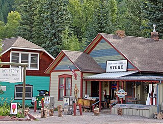
Redstone is an unincorporated town and a census-designated place (CDP) located in and governed by Pitkin County, Colorado, United States. The CDP is a part of the Glenwood Springs, CO Micropolitan Statistical Area. The population of the Redstone CDP was 127 at the United States Census 2020. The Carbondale post office (Zip Code 81623) serves Redstone postal addresses.
This is a list of the National Register of Historic Places listings in Pitkin County, Colorado.
Independence is a ghost town in the U.S. state of Colorado. It is located just off State Highway 82 in the eastern corner of Pitkin County, below the Continental Divide. It was the first settlement established in the Roaring Fork Valley, after gold was struck in the vicinity on Independence Day, July 4, 1879, hence its name. In 1973 it was recognized as a historic district and listed on the National Register of Historic Places as Independence and Independence Mill Site, one of two ghost towns in the county so recognized. It has also been known historically by other names—Chipeta, Mammoth City, Mount Hope, Farwell, Sparkill and Hunter's Pass.
The Redstone Historic District is located in and near the unincorporated community of that name in western Pitkin County, Colorado, United States. It includes the original community of Redstone as built by Colorado Fuel and Iron (CFI) for the coal miners it employed. In 1989 it was recognized as a historic district and listed on the National Register of Historic Places.
The Redstone Inn is located on Redstone Boulevard in Redstone, Colorado, United States. It is a structure in the Tudor Revival architectural styles built at the beginning of the 20th century. In 1980 it was listed on the National Register of Historic Places. It is also a contributing property to the Redstone Historic District listed on the register nine years later.
John Cleveland Osgood was a self-made man who founded the Colorado Fuel and Iron Company and Victor-American Fuel Company but has been referred to as a robber baron. He also created Redstone, Colorado.
The Osgood–Kuhnhausen House, also known as Carina's Cottage, is located on Redstone Boulevard in Redstone, Colorado, United States. It is a timber frame structure built at the beginning of the 20th century in the Tudor Revival architectural style. In 1983 it was listed on the National Register of Historic Places.
Redstone Castle, also known as Cleveholm or Osgood Castle, is a mansion south of Redstone, Colorado, United States. It is a large timber frame structure built in the early 20th century as the home of John C. Osgood, founder of the Colorado Fuel and Iron Company, in a simplified version of the Stick style. In 1971 it was added to the National Register of Historic Places, the first property in Pitkin County to be listed. It was later additionally listed as a contributing property to the Redstone Historic District.
The Osgood Gamekeeper's Lodge is located along State Highway 133 near Redstone, Colorado, United States. It is a timber frame structure built at the beginning of the 20th century. In 1989 it was listed on the National Register of Historic Places.
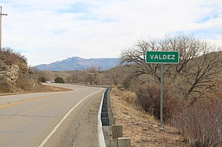
Valdez is an unincorporated community and a census-designated place (CDP) located in and governed by Las Animas County, Colorado, United States. From 1907 to 1960, Valdez served as a company town for Colorado Fuel & Iron and its Frederick coal mine, the company's most productive and second largest. The population of the Valdez CDP was 46 at the United States Census 2020. The Trinidad post office serves the area.
Victor-American Fuel Company, also styled as the Victor Fuel Company, was a coal mining company, primarily focused on operations in the US states of Colorado and New Mexico during the first half of the Twentieth Century. Prior to a 1909 reorganization, the business was known as the American Fuel Company.
Berwind is a ghost town in Las Animas County, Colorado, nestled in Berwind Canyon 3.1 miles (5.0 km) southwest of Ludlow and 15 miles (24 km) northwest of Trinidad. The settlement was founded in 1888 as a company town for the Colorado Coal & Iron Company and, from 1892, was operated by the Colorado Fuel & Iron Company. It was a battle site in October 1913 and April 1914 during the Colorado Coalfield War, housing a Colorado National Guard encampment during the latter stages of the conflict.
This page is based on this Wikipedia article Text is available under the CC BY-SA 4.0 license; additional terms may apply. Images, videos and audio are available under their respective licenses.